Mungo Hut


Maintenance Status
Mungo Hut is a maintain-by-community project with Rob Brown of Wanaka as signatory. Rob and his friends did a comprehensive makeover on Mungo in December 2015. The project was jointly funded by Back Country Tust and Permolat. Valley access to Mungo is a mix of river travel and was maintained in places as a "marked route" by DOC. The fords on this route have not been reliable and the DOC maintained tracked section to Saddle Creek was last cut in January 2020. In April 2019 a Permolat crew went in and reopened some sections of an old NZFS track up the TR of the valley which provides an access option to Mungo Hut without requiring fords of the River. At the same time an old cullers route providing direct access to the southern end of the Toaroha Range was cut and marked. Two short connecting tracks from the Hut to the upper Mungo and Park Stream are not officially maintained, but have been kept open by volunteers. Recent extreme weather may have altered things and made travel more difficult but this has yet to be checked out.
Location
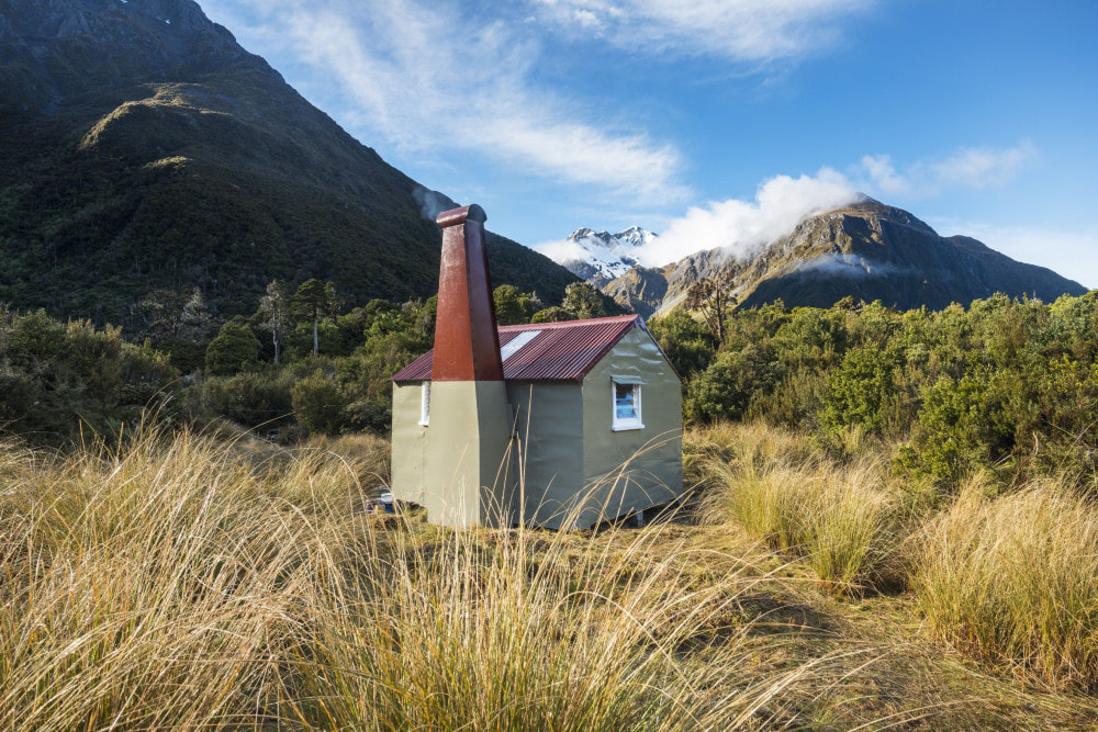
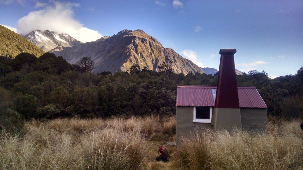
Hokitika catchment. Grid Ref: E1453218/ N5234720 (BV19 532 347). Map BV19. 840m altitude. Mungo is a remote Hut in the truest sense, and remained largely unmodified from when it was built in the early 1960's. It is located in a tussock clearing on a low ridge dividing the Mungo and Park catchments. The peaks of the Main Divide and Toaroha Range ring the upper valley and there are a couple of hot springs half an hour downriver from the Hut, one above and one below Brunswick Stream. The upper is the hotter of the two and can be found in the boulders at the river's edge 50 or so metres above the Brunswick. The lower is more reliable but lukewarm and less inspiring. The forest around the Hut comprises pahautea (mountain cedar), pink pine, toa toa (mountain celery pine), rata, olearia, and nei nei (dracophyllum). It will be interesting to see how much of this remains after a fire in 2021 which was started by a tramper who threw ashes into the bush surrounds. Mungo Hut's visitation rate has been historically low due to its remoteness, averaging 4-5 visits per year. Things got a bit busier after the 2015 maintenance and publicity. Seven parties visited in 2023 and five already noted by early April 2024.
Access
Mungo Hut is most commonly accessed from the western side of the Alps with the odd party coming from Canterbury via Hokitika Saddle, or occasionally Mungo Pass. The main valley route commences at the Toaroha Saddle turn-off a half hour upvalley from Poet Hut. The track sidles along the bush faces above the Mungo River to Saddle Creek where it drops into riverbed. This bit is DOC maintained and was recut in 2020. It is river travel up the TR from Saddle Creek for around one kilometre to where the river cuts into a low bluff. There is a recent slip on the TL just upriver from Saddle Creek that has forced the river in against the TR bank and a bush bash is now required here. Jane Morris cut a rough line through this in June 2021. Further up at the low bluff the river can be forded when low and the TL followed for the rest of the route. Otherwise continue up the TR using short sections of track around the low bluff and a second rocky outcrop just upstream from it. The latter has some narrow rock ledges a couple of meters above the river that require a bit of scrambling to negotiate.
Boulderhop from here to just below the Brunswick where a track enters the bush and does a high detour around a small side creek with waterfall. This can usually be avoided when flows are normal by fording to the TL here, crossing the Brunswick and fording back to the TR above Park Stream. The Brunswick is swift flowing and bouldery and not always easy to ford in its lower reaches. If staying on the TR, there is a section of river travel upstream of the main detour followed another short, tracked section around a low bluff. Continue up the riverbed from here. A track marked by a large orange triangle commences about 100m up from Park Stream and climbs steeply for 15 minutes up a narrow ridge to the hut-site. Normally it would take around three hours from Poet Hut to Mungo Hut, however this can vary depending on river conditions.
If coming from the Toaroha valley there is a direct tops route to Mungo from Toaroha Saddle Biv via an old cullers route down the ridge on the TR of Topo Creek which was cut and marked in April 2019. Head East from the Biv, drop down to the Saddle, and climb from here up onto a flat area at 1400m just above the TR fork of Topo Creek. Drop SE from here onto the ridge bounding the TR of the fork. The top end of the ridge is very steep and exposed in a couple of places and the safest option is to sidle off where required, into a gut on the Topo Creek side, and rejoin the ridge a bit further down. This detour was cruise-taped in December 2019. The ridge flattens further down and there are three waratahs, the bottom-most of which (E1452197/ N5234762 (BV19 522 348)) marks the top entrance of a track that drops East down a steep side-spur towards Park Stream. The track drops into Topo Creek 20 metres above where it enters Park Stream. The Park is crossed and followed upstream for 400m to the start of a track that climbs 60 or so vertical metres up onto the terrace and Hut. Allow 3-4 hours for the trip from the Biv to Mungo Hut depending on conditions. Ice axes and crampons are strongly recommended for the colder months.
Mungo Hut is a maintain-by-community project with Rob Brown of Wanaka as signatory. Rob and his friends did a comprehensive makeover on Mungo in December 2015. The project was jointly funded by Back Country Tust and Permolat. Valley access to Mungo is a mix of river travel and was maintained in places as a "marked route" by DOC. The fords on this route have not been reliable and the DOC maintained tracked section to Saddle Creek was last cut in January 2020. In April 2019 a Permolat crew went in and reopened some sections of an old NZFS track up the TR of the valley which provides an access option to Mungo Hut without requiring fords of the River. At the same time an old cullers route providing direct access to the southern end of the Toaroha Range was cut and marked. Two short connecting tracks from the Hut to the upper Mungo and Park Stream are not officially maintained, but have been kept open by volunteers. Recent extreme weather may have altered things and made travel more difficult but this has yet to be checked out.
Location
Hokitika catchment. Grid Ref: E1453218/ N5234720 (BV19 532 347). Map BV19. 840m altitude. Mungo is a remote Hut in the truest sense, and remained largely unmodified from when it was built in the early 1960's. It is located in a tussock clearing on a low ridge dividing the Mungo and Park catchments. The peaks of the Main Divide and Toaroha Range ring the upper valley and there are a couple of hot springs half an hour downriver from the Hut, one above and one below Brunswick Stream. The upper is the hotter of the two and can be found in the boulders at the river's edge 50 or so metres above the Brunswick. The lower is more reliable but lukewarm and less inspiring. The forest around the Hut comprises pahautea (mountain cedar), pink pine, toa toa (mountain celery pine), rata, olearia, and nei nei (dracophyllum). It will be interesting to see how much of this remains after a fire in 2021 which was started by a tramper who threw ashes into the bush surrounds. Mungo Hut's visitation rate has been historically low due to its remoteness, averaging 4-5 visits per year. Things got a bit busier after the 2015 maintenance and publicity. Seven parties visited in 2023 and five already noted by early April 2024.
Access
Mungo Hut is most commonly accessed from the western side of the Alps with the odd party coming from Canterbury via Hokitika Saddle, or occasionally Mungo Pass. The main valley route commences at the Toaroha Saddle turn-off a half hour upvalley from Poet Hut. The track sidles along the bush faces above the Mungo River to Saddle Creek where it drops into riverbed. This bit is DOC maintained and was recut in 2020. It is river travel up the TR from Saddle Creek for around one kilometre to where the river cuts into a low bluff. There is a recent slip on the TL just upriver from Saddle Creek that has forced the river in against the TR bank and a bush bash is now required here. Jane Morris cut a rough line through this in June 2021. Further up at the low bluff the river can be forded when low and the TL followed for the rest of the route. Otherwise continue up the TR using short sections of track around the low bluff and a second rocky outcrop just upstream from it. The latter has some narrow rock ledges a couple of meters above the river that require a bit of scrambling to negotiate.
Boulderhop from here to just below the Brunswick where a track enters the bush and does a high detour around a small side creek with waterfall. This can usually be avoided when flows are normal by fording to the TL here, crossing the Brunswick and fording back to the TR above Park Stream. The Brunswick is swift flowing and bouldery and not always easy to ford in its lower reaches. If staying on the TR, there is a section of river travel upstream of the main detour followed another short, tracked section around a low bluff. Continue up the riverbed from here. A track marked by a large orange triangle commences about 100m up from Park Stream and climbs steeply for 15 minutes up a narrow ridge to the hut-site. Normally it would take around three hours from Poet Hut to Mungo Hut, however this can vary depending on river conditions.
If coming from the Toaroha valley there is a direct tops route to Mungo from Toaroha Saddle Biv via an old cullers route down the ridge on the TR of Topo Creek which was cut and marked in April 2019. Head East from the Biv, drop down to the Saddle, and climb from here up onto a flat area at 1400m just above the TR fork of Topo Creek. Drop SE from here onto the ridge bounding the TR of the fork. The top end of the ridge is very steep and exposed in a couple of places and the safest option is to sidle off where required, into a gut on the Topo Creek side, and rejoin the ridge a bit further down. This detour was cruise-taped in December 2019. The ridge flattens further down and there are three waratahs, the bottom-most of which (E1452197/ N5234762 (BV19 522 348)) marks the top entrance of a track that drops East down a steep side-spur towards Park Stream. The track drops into Topo Creek 20 metres above where it enters Park Stream. The Park is crossed and followed upstream for 400m to the start of a track that climbs 60 or so vertical metres up onto the terrace and Hut. Allow 3-4 hours for the trip from the Biv to Mungo Hut depending on conditions. Ice axes and crampons are strongly recommended for the colder months.
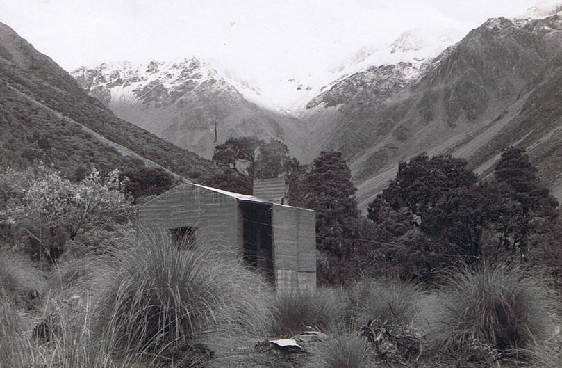 The original Internal Affairs Hut at Mungo looking up into the head of the valley: Photo Ted Smith 1961
Type
Mungo Hut is an NZFS S81 four-bunk design with open fire, built in 1962. It replaced an old hut built by Internal Affairs in the 1950's. A toilet was constructed around 1983. A small stream next to the Hut supplies water and firewood can be scrounged from the surrounding forest.
Condition
Mungo Hut had its exterior repainted and resealed, some of the framing and rotten floorboards replaced, and the chimney and fireplace repaired and re-concreted by DOC in 2004. In 2015 Rob's crew replaced two piles, took the roofing iron off and replaced all the old building paper with chicken wire. One skylight was replaced and the other replaced with iron for structural reasons. The ridgeline was replaced, and new flashing installed over the eastern window. Most of the building paper in the walls was replaced with and most of the interior lined with 12mm ply. The cavities were vented with 10mm holes at top and left unlined at the bottom to avoid moisture build-up. A fair amount of rotten framing was replaced, and the cupboard rebuilt. The centre rafter was strengthened along with some of the purlins. The bunks were properly strengthened and finished. Some of the iron was refastened with tech screws and the exterior sealed and painted. The doorstep was excavated and redone in rocks and concrete and the toilet painted. The door handle was replaced, and door rat proofed. A new splash back was added in cooking area. A small woodshed was constructed, the helipad and Hut surrounds cleared, and the access tracks down to the river recut. The chimney tends to smoke a bit if the windows are closed possibly due to the recent fireplace modifications.
Routes
The route to Hokitika Saddle begins at the Hut and skirts around the eastern fringes of the bog at the southern end of the Hut clearing. A short section of track leads through the scrub at the end of the bog, down to the river. It is pretty well marked and easy to follow, with just a bit of regrowth. The bottom entrance is incorrectly marked on the Topo map as starting at a small side-creek but is in fact further downriver at around E1453255/ N5234540 (BV19 533 345). An easy couple of hours boulderhopping should get you to the base of Hokitika Saddle which has a near-vertical slot leading up to it. A much easier approach can be found up the large scree (or snow gully in winter) that enters the TL of the Mungo at around E1455908/ N5235847 (BV19 559 358). Head up the scree and exit on the TL about 2/3's of the way up. Climb from here directly onto the Main Divide. The bottom of the scree is quite steep, but the gradient lessens further up, and it is an easy stroll North along the Divide to the Saddle. Mt Ambrose is an easy climb from here, and travel further along to Clarkes Pass and beyond is pretty straightforward.
Access down into Griffiths Stream on the Canterbury side is via the NE spur of point 1850m. The creek directly below the Saddle is also reported to be navigable. Once in Griffiths Stream it is a long, fairly easy plod down to the Unknown - Wilberforce confluence. Urquhart's Hut is an hour's travel up the Wilberforce from the Unknown. Allow around eight hours for the crossing from Mungo Hut to Urquhart's Hut in good conditions (some people are taking a lot longer). Ice axes should be carried during the colder months of the year.
Mungo Pass is accessed from the upper Brunswick Stream, up a small side-creek that enters on the TR, around E1452935/ N5232200 (BV19 529 322). Head up the creek and exit on the TL up a large obvious scree that leads to the Pass. The faces on the Gibson Stream side of the Pass are steep and eroding, and extreme care is needed when descending. Snow gear may be needed for Winter and Spring crossings and a rope may come in handy at other times. The stream is negotiable in its upper reaches with one 4m waterfall to bypass. Further down at E1456348/ N5231687 (BV19 563 317) it drops into a gorge, and it is necessary to exit up some steep faces on the TL and sidle around the back of point 1290m. The route back into the Gibson is down a rib on the TL of the first side-creek downvalley. This is very steep with small bluffs at the bottom that need skirting. Care is needed here also. The rest of the journey down the Gibson to the Unknown Stream is reasonably straightforward. Allow a full day for the crossing from Mungo Hut to Unknown Stream Hut.
Mt Bryce is a fairly easy climb from the head of the Brunswick Creek, and in late summer and autumn is mostly scree travel with the odd patch of permanent snow. A rock buttress in the NW approaches to Mt Bryce makes continued travel along the Divide to Mistake Col more of a technical affair.
A high-level crossing of Brunswick Ridge over to Sir Robert Creek can be done from the upper Brunswick valley. Access from Brunswick Creek onto the Ridge is up an obvious broad spur that comes in at around the 1000m contour. The ridge is followed to a dip at around E1451902/ N5231267 (BV19 519 313) where it is possible drop off down a steep scree that enters the TR of the large unnamed side-creek below. The top of the scree is very steep and would require ice axes, crampons and possibly a rope during the colder months. The bluffs above the scree are active during the warmer months with occasional rockfalls. The gradient gets gentler as you get lower down the scree. Follow the side-creek down to Sir Robert Creek and boulderhop upstream from here to Sir Robert Hut. Allow 6-7 hours for the crossing from Mungo Hut to Sir Robert Hut.
For those wishing to exit Mungo via the Topo Creek tops track and Toaroha valley, a direct route to Top Toaroha Hut exists that avoids doing the dogleg around to Toaroha Biv. Simply continue at the 1400m level along the prominent bench South of Mt Bannatyne and drop into Top Toaroha Basin directly down an open gut that comes out onto the tussock flat adjacent to the Hut.
For the more experienced there a great high-level route out from Mungo Hut along the Toaroha Range. There are potential stopovers at a number of remote huts and bivs. The track down into Park Stream (recut in 2015) starts at the NW end of the Hut clearing and drops steeply down into the catchment. Park Stream has been scoured out by numerous extreme weather events and is all boulder and gravel travel. Exit the Park near its head at a side-creek that enters on the TR around E1452917/ N5236770 (BV19 529 368). The side-creek turn into a rocky gut that can be followed all the way up to the low point between Mt Bannatyne and Chamberlain. The top of the gut is steep and eroding, snow-filled for a lot of the year, and can be icy near the top. Recent reports indicate it's become more difficult over time. It is recommended that ice axes and crampons be carried during the colder months. There is a short vertical pitch on the Range just South of Mt Chamberlain can be avoided by sidling around on Park Stream side, or a small, usually snow-filled basin on the Chamberlain Creek side. The travel from Mt Chamberlain to Zit Saddle is straightforward. Water needs to be carried however, as there are no tarns on this stretch.
Top Kokatahi Hut can be accessed from the low point between Mt Chamberlain and point 1694m by dropping into the head of the Kokatahi. The river is followed from here and is rough going in places with a few small waterfalls that need to be negotiated. This section could possibly be a bit avalanche prone during the colder months. Allow 4-5 hours from Mungo Hut to Top Kokatahi in good conditions.
Yeats Ridge Hut and Crystal Biv can be accessed down the prominent spur that runs West from point 1694m. The spur forks at the 1300m contour and the NW branch is taken for Yeats Hut. There are a few waratahs and stakes (the top waratah is at E1449761/ N5238689 (BV19 498 387)) leading to a cut and marked trail down a scrubby face. Poles lead north from the bottom of this section through scattered scrub onto a low ridge bounding Zit Creek. A section of track runs along the ridge to an open slope above the basin in which the Hut is located. Wooden stakes lead across the basin and up to the Hut. Allow at least six hours in good conditions for this crossing.
Crystal Biv is accessed down the SW fork of the spur and is visible in fine weather from the 1200m contour. It is easy travel down to the Biv with a bit of scattered scrub that can be negotiated by veering north around the fringes of the big tarn. Allow 5-6 hours from Mungo Hut to Crystal Biv in good conditions.
Adventure Biv can be accessed by continuing along the Toaroha Range. There is a narrow section of ridge just before Zit Saddle that needs to be sidled on the Kokatahi side. The slopes are steep here and care is required in wet or icy conditions. Recently, and with the increased popularity of this traverse, a few parties have found this bit too exposed for comfort. It shouldn't be a problem for those confident with heights but take a rope if you are unsure. Continue past Zit Saddle to where the poled route from Top Kokatahi Hut crosses over. The route is incorrectly drawn on NZ topomaps, crosses over higher than marked, and drops into Toaroha down the spur due north of the one indicated (see the Adventure Biv page). The poles take you down a steep tussock face onto a narrow rib on the Toaroha side. A short, tracked section leads from the bottom of the rib through a band of scrub into the creek bed of the TR branch. Cross the creek and follow a rough trail that sidles through scattered scrub over to Adventure Ridge. A short section of track leads down the ridge through the alpine scrub to the Biv. Don't make the mistake of dropping directly from Zit Saddle into Zit Creek unless you have a rope and a spare day up your sleeve. Allow 7-9 hours for the traverse from Mungo Hut to Adventure Biv.
Repairs needed.
The rest of the Hut's piles are pretty good, but some will reach the end of their life in the next 10 years. Rob didn't do the foyer side in the southwestern corner and the stud here is soft and will need replacing at some stage. More 3x2 framing will be required for this. The gable above the door will need a bit of strengthening at some stage. There is spare paint above foyer if anyone feels like giving a second coat to woodshed or do any touching-up.
Provisions on Site
The Hut has a spade, a shovel, a spare shovel head, a cast iron frypan, a camp oven, 2 buckets, a bow saw, 4 billies, a small library, a small seat, a hammer, an aluminium basin, a hearth shovel and hand broom, a broom, an axe, a few nails and permolat, and some spare louvre panes.
