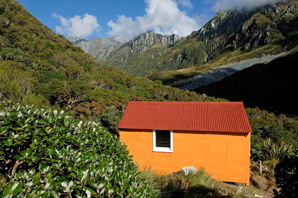
County hut
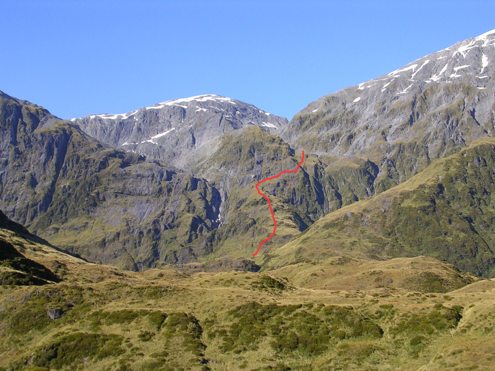
 Canary Creek tops access
Maintenance Status
County Hut was originally called Kensington Hut and is referred to as such in early NZFS guides and documents. This name never stuck however, and County was already in common usage when I first visited in 1974. The hut is currently minimally maintained by the Department of Conservation, which basically means it isn't, although they will fly in from time to time to attach a bunk rail, warning sign, or other compliance appendage. in 2018 Geoff Spearpoint and friends did some scoping and trackwork and in 2021 he used some Back Country Trust funding to do some comprehensive maintenance and more trackwork. The access track up the County Stream from the Waitaha valley is legendary for its toughness and while no longer officially maintained, it has been kept open by Permolat volunteers since 2006.
Location
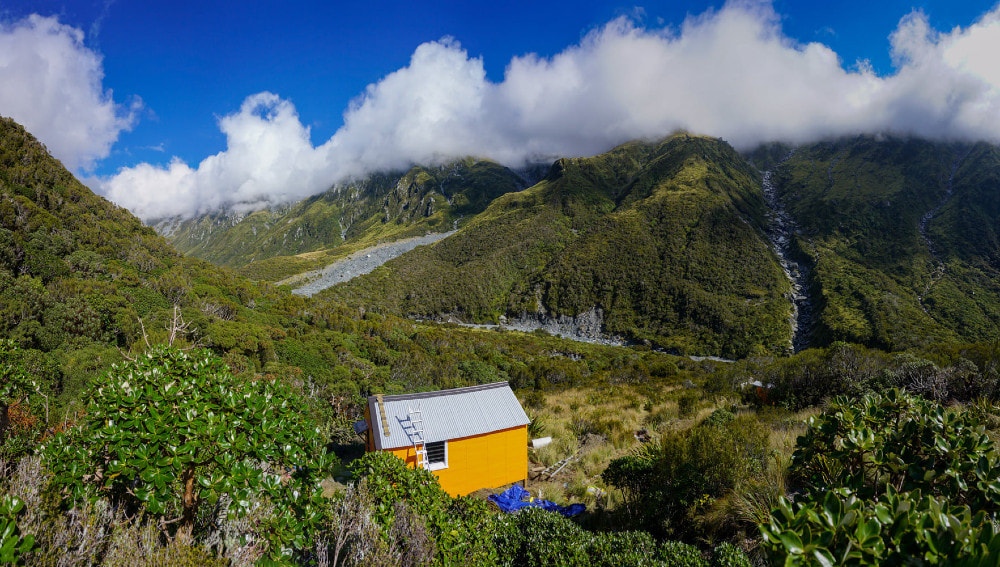
Waitaha catchment. Map BW18. Grid Ref: E1425190/ N5219383 (BW18 252 194). Altitude 995m. The County Stream is the largest tributary of the upper Waitaha River, and backs onto the pristine alpine snowfields and glaciers of the Mt. Evans massif. The Hut is located on a high terrace on the TR of the Stream, just below the Bloomfield Creek confluence. The surrounding vegetation is a mix of alpine scrub with open tussock clearings. County Hut has always been a low-use hut with visits averaging around four per year currently. Along with walk-in parties there is the odd fly-in of climbers doing the Red Lion or Mt. Evans.
Access
The ruggedness of the Waitaha and County valleys pose access issues even when the tracks are in good order. The Permolat group has done several recuts of the County track since taking over maintenance from DOC. The last of these was in May 2021. The bit from Moonbeam Hut up the main valley to the County turnoff was recut by a DOC/ volunteer group in February 2019.
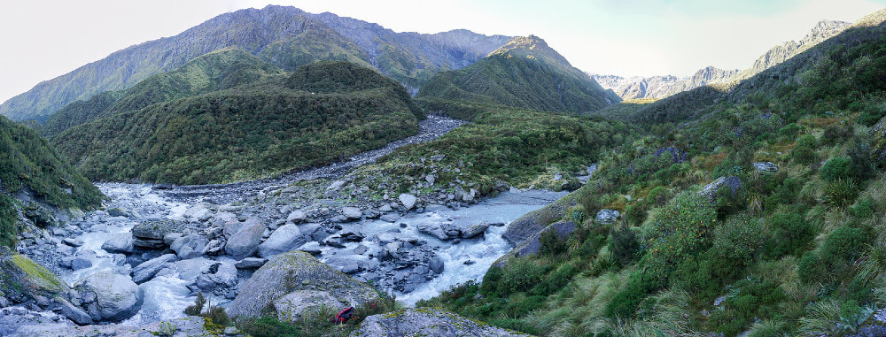
The track from Moonbeam follows the TL terraces of the Waitaha for around 20 minutes passing through some beautiful stands of Hall's Totara, pahautea and southern rata. It drops from the terrace down a steep bank to the riverbed just before Dorothy Creek, crosses Alexander Creek, and re-enters the bush. From here it sidles along the bush faces passing a reasonable dry rock just before the Top Waitaha turnoff. The County track continues up-valley from the turnoff sidling above the Waitaha, then turns and sidles up and into the County valley. The terrain is steep, rough and eroding with the track eventually angling towards the riverbed opposite O'Reilly Creek. A flood channel is followed for 100m to where the track re-enters the scrub and climbs up parallel with the river before dropping back into it where the valley starts to level a little. From here it is rough river travel with large boulders and a bit wading here and there. There is a short scrub detour where the river has cut against a shingle bluff about half an hour below the Hut.
When the river levels are low (more common in winter), the County can be crossed and recrossed, affording a straighter and more direct line. During the warmer months snow and glacial melt swells the river levels considerably and it is necessary to stay on the TL. The best crossing to the Hut has for a while been just below Canary Creek, however the fords here change, are unpredictable and should be tackled with care. The track up to the Hut starts 200m up the TR of Bloomfield Creek, its entrance marked with a cairn and permolat. Allow 4-6 hours from Moonbeam Hut to County Hut in good conditions. Don't attempt this route if the rivers are running high.
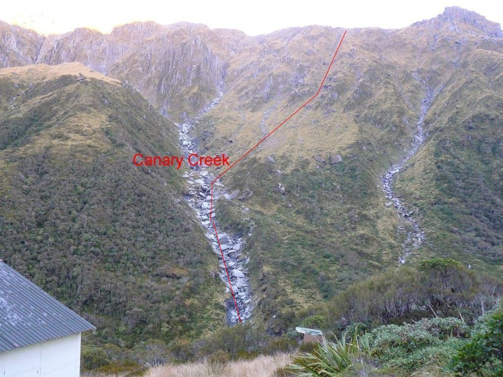
A great fine weather alternative route to County Stream exists over the Clearview Spur tops. This is accessed via an old NZFS track directly behind Moonbeam Hut, recut and marked in 2015 and retrimmed in 2021. It goes up a narrow ridge between Dorothy Creek and Moonbeam Torrent to around the 1030m contour, where it leaves the ridge and drops into the head of Dorothy Creek. The Creek by this stage is dry and the creekbed provides access through scattered alpine scrub to the open tussock. Climb in an easterly direction from here up onto a flat section of Clearview Spur just above point 1690m. There are great views from this point of Mt. Evans and the Red Lion. The County basin is accessed down the tussock faces between Canary Creek and the unnamed side-creek downriver from it. A band of alpine scrub further down can be avoided by dropping into Canary Creek around the 1130m contour and following the creekbed. Allow 4-5 hours from Moonbeam Hut to County Hut in good conditions.
County Hut has a small helicopter platform dug into the slope, just next to the Hut.
Type
County Hut was one of the last NZFS S70 six-bunk designs, built in 1971. It is lined, has a roof-fed water tank, and a toilet. There is no fire or woodburner.
Condition
County Hut is in tip-top condition currently. Repainting and maintenance work was carried out by DOC in 2003 and a new water tank installed. Geoff Spearpoint added a door flashing and a proper door handle to supplement the bolt and did some repairs and weatherproofing around the door sill in 2018. In March 2021 Geoff organised and lead a party of five for eight days of restoration work. The roof ridging, gable flashing, and three sheets of corrugated iron were replaced with coloursteel. The clearlight was replaced and a clear plastic drip liner added, and lead head nails were replaced with screws and storm clips. The vegetation and ground were cleared all around and all four corner piles were dug out and replaced to code with over 700kg of ready mix being prepared by hand. The roof and exterior were scraped, rust converted, primed, and top coated twice. The rainwater catching system was restored. The window frames and sills were sealed, flashed, sanded and repainted. The toilet was re levelled, re-roofed, scrubbed out, prepped and painted. Inside the Hut, some water damaged ply lining was replaced, the bunks were moved, and the interior washed and painted. Various details like the legacy first aid kit, the outside bench, water tank stand, doors and seats were cleaned sanded painted. The helipad was cleared, extended and stabilised and the track up from the Bloomfield trimmed and marked.
Routes
Most of the routes in the County catchment are alpine ones, and as such require reasonably high levels of experience and fitness, and appropriate gear.
There is a reasonably popular crossing from the head of the County valley into the Smyth catchment of the Wanganui River via Smyth Saddle. River travel upstream from the Hut is reasonably straightforward when the County is low, with one small gorge to negotiate around the 1060m contour, just before the basin opens out into tussock. There is a 2–3-person rock biv in the top basin marked with a cairn around BW18 272 171. It is dry and reasonably roomy but needs work levelling the sleeping platform. Access up to the Saddle is up a prominent side-creek that enters the County at E1426840/ N5217273 (BW18 268 173). Exit the Creek up a gut on the TL around the 1450m contour and climb through a band of large, shattered boulders onto a flat bench by point 1667m. Head SW along the 1600m contour and head down a prominent spur that drops in a NW direction towards the Smyth/ Bradshaw confluence. Veer South off the spur at the flat area at the 1230m mark and drop directly down into the Smyth. Travel downriver is rough with large boulders fringed by alpine scrub. The TR easier lower down if you are able to ford. Allow a full day from County Hut to Smyth Hut. The swingbridge across the Wanganui River just above the Smyth confluence was washed out in 2013 and the Wanganui is not always an easy ford.
A more direct route between County and Smyth that hasn't been tried to the best of my knowledge but looks doable on the map is up the big side-creek, two up from Canary, to Point 1715m and over into the head of Bradshaw Creek.
 The route down from the alpine lake in the middle branch of Reid Creek.
Access from County Hut over the Bloomfield Range to Top Waitaha Hut is up a steep rib on the TR of Bloomfield Creek and the col between Mt. Bloomfield and Artist Dome. The side-creek on the TR of the rib is also negotiable above the two waterfalls in its lower and mid sections. It is relatively easy to traverse Mt. Bloomfield and there are a number of routes off the mountain into the Top Waitaha basin. Mt. Bloomfield's NW ridge has a steep, exposed section lower down which may be a bit difficult for some to downclimb without a rope. The ridge connects with some tussock terraces on the TL of Reid Creek, and these can be followed down to the Waitaha. There is a short scrub-bash at the foot of the terrace just above the main basin. Several other lines exist down the East faces of Bloomfield from point 1857m that would provide more straightforward access to the Hut.
Another option is to drop from the col into the middle branch of Reid Creek where there is now a reasonably large ice-lake. Head slightly north of the col before dropping down to avoid a band of bluffs directly below, then sidle around the benches above the lake's TL into a narrow dry gut just West of point 1686m. This becomes a creek further down, and this is followed to the top of a waterfall around the 1500m contour. Exit on the TR here and sidle onto the steep bluffy spur between this creek and the lake's outlet creek.
The spur looks daunting from the Waitaha basin, but there is an OK route down through a series of small benches through the bluffs to where the spur flattens. Drop from the foot of the spur into the West branch of Reid Creek, cross, and climb up onto a terrace with tarns on the TL. Follow the terrace to its end and drop down to the Waitaha basin passing through a narrow band of alpine scrub at the very bottom. Times for the crossings will vary depending on fitness and conditions, but allow a whole day. Some fitter types claim to have done it in five hours. There is permanent snow on Mt. Bloomfield's summit and a few patches on either side of the col. The crossing can usually be done without ice axes in late summer/ autumn, but it is recommended that one be carried anyway.
Artist Dome is a relatively easy scramble from the either the col route or the ridge on the TL of Bloomfield Creek. A band of scrub at the bottom of the ridge can be avoided by following the Creek to around the 1150m contour, then exiting up a steep gut on its TL.
The Smyth Range can be traversed to the West from County Hut and a track down Headlong Spur provides access to Kiwi Flat Hut. Canary Creek is normally used to access Clearview Spur. There is short, eroding. exposed section just below Point 1945m that needs to be crossed with care. Mts. Barry and Neville are relatively easy to traverse, and it is possible to drop roughly NW from Neville's summit onto a flat bench at 1850m and continue to sidle from there around to Headlong Spur. The Headlong Spur track has been kept open from the early '90s by volunteers. In March 2021 DOC used some Jobs for Nature funding to fly a Hiking NZ crew in to recut the track. They didn't do a very good job at the top end but at least the track is followable. It takes you down the Spur to where it connects with the Waitaha valley track on a terrace 30 minutes upriver from Kiwi Flat Hut. A crossing from County to Kiwi could theoretically be done in a long day in good conditions, however it makes more sense to take a tent and break it in two.
It is also possible to continue along the Smyth Range to Scamper Torrent Hut. There is one steep section on the Range adjacent to the Kea Glacier which is generally snow-free from late summer but would require ice axes at other times if conditions were icy. The rest of the Range is relatively easy travel and there are plenty of good campsites. Scamper Torrent is accessed by dropping in a WNW direction down some sloping benches under Mt. Durward into the small basin on the lee side point 1397m. Follow the small stream from the basin to where it drops over a waterfall and continue sidling West across the tussock faces onto the broad spur bounding the TR of the main branch of Scamper Torrent. This spur has a small creek bisecting it. The high ground on either side of the creek can be followed through patchy scrub down into the main basin. The Hut is visible most of the way down. Allow a long day from the crossing from County Hut or take a tent and break it into two.
A route over to the Wilkinson catchment in the Whitcombe valley via McKenzie Col at the head of the County, should only be attempted by experienced alpinists. The Col has seasonal crevasses, permanent high rockfall danger, and the County approach is a near-vertical rock chute. The route down to Wilkinson Hut in the Whitcombe valley is untracked and very rough. The Bevernage Rock Bivs on the TR of Seddon Creek are shallow overhangs, the largest of which would take two people at a squeeze. A large boulder cascade immediately below the bivs is very rough going with thick alpine scrub on the fringes, and travel is marginally easier on the TL. A second cascade in the Wilkinson just below the Seddon Creek confluence has larger boulders, scrub surrounds, and is more difficult than the first due to the increased volume of water. The river is fast flowing and opaque, and the submerged rock surfaces very slippery. Fording here is usually not an option unless you can jump the boulders and the levels usually rise significantly over the day in the warmer months with snow melt. Once the bottom of the cascade is reached the best option is to climb up into Walcott Creek and cross a large mostly open shingle fan to the toe of the ridge on the Creek's TL. A reasonable dry shelter can be found further up the Creek under a gigantic boulder. Once past the Walcott, continue down the Wilkinson on the terraces staying reasonably close to the toe of the hill. The deer trails here provide easier travel than the slippery boulders on the river's edge. The TL of the Whitcombe is followed from the Wilkinson confluence down to the Hut, mostly boulder hopping with a few small detours into the bush. This last bit takes around an hour. Allow a couple of days for this trip.
Repairs needed.
Nil currently.
Provisions on Site
Four billies, a large and small frypan, two wash basins, two aluminium buckets, a hand brush and shovel, a broom, a shovel and spare handle, a slasher (blunt) and spare handle, an axe and spare handle, an NZFS vintage first aid cabinet, a crow bar, a food bin, and the leftover paint in buckets. Geoff has left a bunch of tools for ongoing general maintenance and there are two wooden roof ladders under the Hut and an aluminium ladder in the loft space.
