Moonbeam Hut
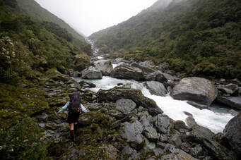
 Rough going - the upper Waitaha above Chainman Creek: Photo Mark Watson/ www.highlux.co.nz 2008
Maintenance Status
Moonbeam Hut was designated as fully maintain by the Department of Conservation in 2003 but no work was actually done after that. in 2020 Justin Venable and Keith Riley from Hokitika signed an M.O.U. with the Department and in February '21, along with Phil Palzer and Al Ritchie, gave the Hut a major makeover. Keith is planning to go back in at some point and replace a few more piles. The access tracks to Moonbeam have been maintained by the Permolat group since 2007. Our last cut was done in October 2021 and the track which traverses some rough and undulating terrain is still in reasonably good shape.
Location
Waitaha catchment. Map BW18. Grid Ref: E1421728/ N5221267 (BW18 217 213). Altitude 475m. Moonbeam Hut is sited on a bush terrace on the TL of the Waitaha, a short distance upriver from Moonbeam Torrent. It's a comfy stopover mostly for those passing through to Ivory Lake in the valley's headwaters. Visits to Moonbeam fell off markedly in the 1990's and early 2000's due to the tracks overgrowing but picked up a little after Permolat got involved, and again after Ivory Lake became a trampers' Holy Grail. It's unlikely that it will ever be a high-use hut because of the rough nature of the valley.
Access
The track to Moonbeam from Kiwi Flat Hut starts at the Kiwi Flat Hut door and climbs steeply up onto a wedge of terrace that separates the Waitaha from Whirling Water. There is a half hour of relatively flat travel to the Headlong Spur turnoff after which the track drops off the terrace and begins a long sidle across the bush faces above the Waitaha Gorge. After about 20 minutes the track veers sharply uphill and climbs to 510 metres to get around two large active slips, before dropping back to the original trackline and continuing upvalley. There are a number of ups and downs before it starts descending to the River just upstream of Mark Creek.
From here it is around an hour's boulder hopping with a couple of small bush detours to Moonbeam Hut. Moonbeam Torrent, a short distance downriver from the Hut, is large and swift and usually impassable after heavy rain. The track up to the Hut starts on the riverbed 10 minutes upstream from the Torrent, and climbs steeply 60 vertical metres onto the terrace on which the Hut is located. Allow 4-5 hours to get from Kiwi Flat to Moonbeam Hut.
The chopper pad directly in front of the Hut had the surrounding regrowth cleared in 2015.
Type
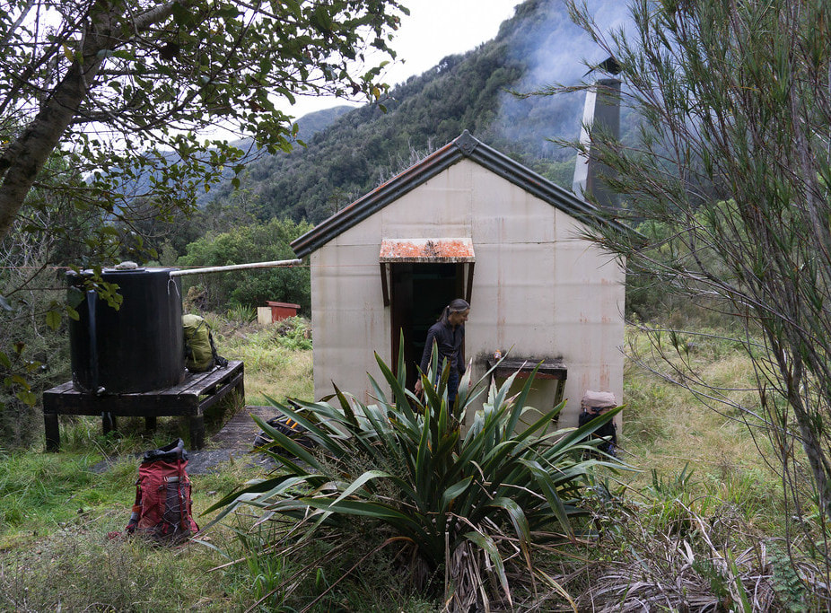
Moonbeam Hut is a standard NZFS S70 six-bunker and was built in 1971. It is lined and has an open fire and a roof-fed water tank. There is a toilet and a rudimentary woodshed.
Condition
Moonbeam Hut is in good condition now thanks to the recent makeover. It was painted and had some minor repairs done by DOC in 2003. In 2019 a DOC/ volunteer group replaced three piles, the roof clearlight sheet and some of the inner roof ply. The leadhead nails in the roof were replaced with tech screws and a hole patched in the door alcove. Four new mattresses were brought in and the other two cleaned. The toilet was shifted also. In February 2021 Justin and Keith's team resealed and repainted the Hut exterior, some roofing screws were added and the ridge capping laps sealed, a new woodshed was built, the interior was repainted and damaged linings replaced, the benchtops were replaced, some new varnished rimu shelves and a mantelpiece added, a kawhaka handle added to cupboard door, and the hut seats repaired and painted. The chimney flashing was rust-killed and sealed, a new fireplace backing was installed and filled with river stones with extra sheet metal between stones and chimney. This will create a more significant air gap and reduce corrosion. A new stainless steel baffle was installed between the Hut wall and the fireplace beneath the mantelpiece and a new hearth laid. The old bench top was installed as an interior toilet pee shield. 50 plus years of accumulated bits and bobs, plus building waste were packaged into fertilizer sacks for removal. The woodshed was built by Keith and crew from scraps left over from maintenance. It is in the shadow of the hut and only walled on the back and one side. The weather gets in and half the woodpile seems to stay wet. The piles apart from the three new ones are original, probably silver pine, and are rotting at ground level (they range from 400 to 200 above ground).
Routes
The Waitaha is tracked upriver from Moonbeam as far as Chainman Creek and this bit was recut by the DOC/ volunteer crew in February 2019. From here it untracked river travel to Top Waitaha Hut. This upper section is notoriously long and rough with cascades, big boulders, and alpine scrub to negotiate. If it took you a lot longer than five hours to get from Kiwi Flat to Moonbeam Hut, we'd strongly advise you to reconsider continuing up the valley. There are sufficient tales of woe in the Moonbeam hut to reinforce this message, so ignore it at your peril.
From Moonbeam the track continues along the river terrace on the TL through a beautiful patch of montane forest (tall pahautea and totara). The track drops down a steep bank to the riverbed just before Dorothy Creek, re-entering the bush just past Alexander Creek. It sidles along the faces from here to the County turnoff, passing a reasonable dry rock just before the signpost. The main valley track drops from the turnoff down to the river and crosses the swingbridge to the TR. A short stretch of track leads to a section of riverbed which is followed to a small unnamed side-creek at the start of the Windhover Gorge. The track restarts 20 metres up the TL of the creek and climb/ sidles around the faces above the gorge, eventually dropping into a creek with attractive water-sculpted rock sides. A more serious climb begins here up the ridge on the TR of Chainman Creek. At around 900m the track drops off the ridge down a steep rib into the bottom end of Chainman Creek. It crosses Chainman Creek and cuts through a flat area with olearia scrub to the Waitaha riverbed.
For travel in the upper Waitaha above Chainman Creek it is best to stick to the riverbed and use bush detours where necessary. After around 2.5kms of very rough, slow travel the river opens out into a large, open tussock basin. The last bit to the Hut is an idyllic stroll compared to what preceded it. The average travel time from Moonbeam to Top Waitaha Hut seems to be around 11 hours. A few manage nine and a few a lot longer. A recent party that took 22 hours probably shouldn't have been in the valley. Travel on the river sections tends to be easier in winter when river flows are lower with less snow melt, and it is possible wade around some of the boulders or ford and cross back to get a better line.
The track to County Hut continues along the TL of the valley from the Top Waitaha turnoff. The County track continues up-valley from the turnoff sidling above the Waitaha, then turns and climb/ sidles up and around into the County valley. The terrain is steep, rough and eroding with the track eventually angling towards the riverbed opposite O'Reilly Creek. A flood channel is followed for 100m to where the track re-enters the scrub and climbs up parallel with the river before dropping back into it where the valley levels somewhat. From here it is rough river travel with large boulders and a bit wading here and there. There is a short scrub detour where the river has cut against a shingle bluff about half an hour below the Hut.
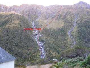
When the river levels are low (more common in winter), the County can be crossed and recrossed, affording a straighter and more direct line. During the warmer months snow and glacial melt swells the river levels considerably and it is necessary to stay on the TL. The best crossing to the Hut has for a while been just below Canary Creek, however the fords here change, are unpredictable and should be tackled with care. The track up to the Hut starts 200m up the TR of Bloomfield Creek, its entrance marked with a cairn and permolat. Allow 4-6 hours from Moonbeam Hut to County Hut in good conditions. Don't attempt this route if the rivers are running high.
 Canary Creek route down to County Hut
A possible alternative for travellers from Moonbeam to County is over the tops via the Clearview Spur track. This wouldn't take much longer than the main valley track in good conditions and there are great views of Mt. Evans and the Red Lion from where you cross over. The track which starts directly behind Moonbeam Hut was recut and marked in 2015 and retrimmed in 2021. It follows the bush terrace on the TR of Moonbeam Torrent and connects with and continues up a narrow ridge between Moonbeam Torrent and Dorothy Creek. At around 1200m it drops into the head of Dorothy Creek, which has become a dry rocky gut by this stage. Continue up the gut onto the tussock faces below Clearview Spur and sidle East to the flat area above point 1690m. Access into the County is down the faces on the TL of Canary Creek initially, then into the Creek itself further down where the scrub thickens. Allow 4-5 hours from Moonbeam to County Hut using this route.
A high-level crossing to the Smyth valley is possible from Moonbeam Hut using Clearview Spur for tops access. The drop-off into the Smyth is from point 1830m on the Smyth Range and the upper valley is good travel to just below the Bradshaw Creek confluence. From here down it is bouldery and rough. A fit experienced party should be able to get from Moonbeam Hut to Smyth Hut in a long day in good conditions. The swingbridge over the Wanganui opposite Smyth Hut was washed away by a flash-flood in early 2013, making a ford necessary at the end of the journey.
The Smyth Range can be traversed in a westerly direction to Scamper Torrent Hut. Tops access from Moonbeam is up the first side creek on the TL of Moonbeam Torrent. An old NZFS route guide recommends using the ridge on the TR of this side-creek, but I don't know of anyone who has tried this. A scrub bash is required to get from of the head of the side-creek to the tussock. The broad North-facing slopes of Mt. Neville are easy travel. There is one steep section on the Range adjacent to the Kea Glacier which is generally snow-free from late summer, but would require ice axes at other times if conditions were icy. The rest of the Range is relatively easy travel and there are plenty of good campsites.
Scamper Torrent is accessed by dropping in a WNW direction down some sloping benches under Mt. Durward into the small basin on the lee side point 1397m. Follow the small stream from the basin to where it drops over a waterfall and continue sidling West across the tussock faces onto the broad spur bounding the TR of the main branch of Scamper Torrent. This spur has a small creek bisecting it. The high ground on either side of the creek can be followed through patchy scrub down into the main basin. The Hut is visible most of the way down from Durward in fine conditions. A longer variation of this route would be to use Clearview Spur for tops access, and traverse Mts. Barry and Neville.
Repairs still needed
The gutter (5.6m in length) and barge board is functional but in poor condition. Extra flashing was installed in the meantime to help direct water as the drain holes in roof are too close to the wall. The remaining original silver pine piles will be replaced when Keith next goes back in. The hearth needs a bucket of mortar to fill between the rocks. There are a few coin size rust holes low on the chimney that need patching. The chimney may have moved slightly away from the hut bowing external wall but this is minimal and appears to be stable. The baffle above fire box against the outer chimney is in poor condition but entirely functional. The woodshed could be walled in a little better using some of the ply off-cuts left at the Hut. The track up from Kiwi needs another trim in places.
Provisions on Site
A large box of nails of various sizes, a large supply of permolat, a small hammer, loppers, an axe, a broom, a shovel, a tomahawk, rasps, flat-files, a ruler, a bow saw, sandpaper, two camp ovens, six billies, two old NZFS food bins, some 5/16th tech screws, an old NZFS first aid kit, a sleeping mat, an aluminium washbasin, and a small tube of sealant. There is a makeshift wooden ladder under the hut, a 600mm pile, a 2.4m 4x4 and some ply off-cuts.


