Scottys Biv
 The original Biv
Maintenance Status
Scottys Biv was designated for removal in a review that the Department of Conservation carried out in 2004. This was due to its low level of use and poor condition. Then interestingly they went in and did some maintenance on it. The Permolat Group got involved in 2006 and I signed our first maintain-by-community contract with the Department. This was a forerunner to a number of other similar agreements and when the contract expired in 2016 Scottys was added to the more general region-wide agreement we had by that stage. Low-level maintenance was carried out over the years by volunteers but by 2021 the Biv was starting to deteriorate. At the end of 2021 the DOC Hokitika carpenters started banging together a brand new biv down at their workshop. In March this year this was flown in to replace the old one. Helicopter costs were covered by the BCT. Permolat made use of the machine to backload a team in to work on the access routes at the end of the Tara Tama Range and from Griffin Creek.
Location
Taipo catchment. Map BV20. Grid Ref: E1470151/ N5259403 (BV20 702 594). Altitude 1050m. Scottys Biv is located amid scattered alpine scrub on a bench in the headwaters of Scottys Creek. A couple of reasonable-sized tarns close by and great views out over the Taipo valley and of the impressive northern buttresses of Tara Tama. Scottys Creek is impassable and so access to the Biv is exclusively via the tops. It is a moderate-hard overnighter and often port of call on longer tops journeys. Prior to its adoption Scottys was being visited once every 3-5 years. A record 10 visits were recorded in 2005 following its initial profiling on this website. Two more bumper years followed in 2016 and 2017 (eight parties each), but since then it's fallen back to 3-4 visits per year.
Access
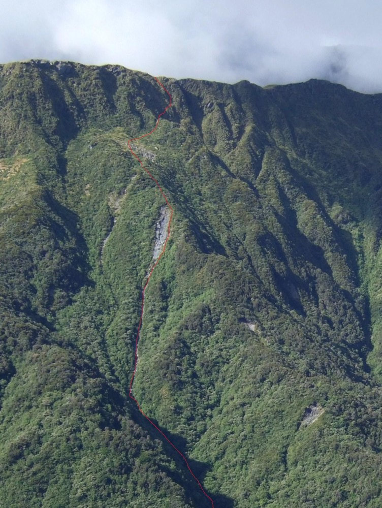
The most direct route to Scottys Biv is via an old NZFS tops track that starts opposite Seven Mile Creek in the Taipo valley. This was last given a tidy-up in March 2022 and is in reasonably good shape. The access road up the TR of the Taipo to Seven Mile Creek from SH73 has been steadily deteriorating over the years, particularly the section up and around the back of Point 338m. Unless you have a high stud 4WD, a six km walk or bike ride from the DOC carpark next to the highway is necessary. The farm track ends at Seven Mile Creek where the landowner currently has two or three diggers doing extensive gold excavation work. The track entrance is roughly 500m downstream of the Seven Mile on the TL of the Taipo. There isn't a particularly good ford here at the moment and crossings should definitely not be attempted when the river is up. It may be necessary to go downstream a fair distance currently to find a safer ford.
The track commences at the mouth of a small side-creek that enters the River just below some shingle bluffs and is marked with a cairn and permolat. Follow the creek up for 100m to where a track exits on the TR and climbs steeply up onto a bush terrace. This is followed at a fairly gentle gradient above the TR of the creek to a broad spur which is steep initially and becomes better-defined around the 850m mark. A plastic water drum at 950m and a smaller 20 litre container at the bush edge provide the only water for a considerable distance. There are a couple of small but easy to miss tarns along the crest of the Range and one just before Scottys Saddle. From the top of the track the route continues through scattered scrub onto point 1371m and along the crest of the range over a second point 1371m to point 1399m. The Biv comes into view here but a direct line to it isn't possible due to some obscured bluffs and scrub gullies. Continue instead along the Range until 200m past the low point between points 1399m and 1406m from where it is possible to descent diagonally towards the Biv at a bearing of roughly 160 degrees. Alternately continue along the Range to point 1406m where waratahs and cairns lead in a SE direction straight down the tussock faces to the Biv. A fit, experienced party should be able to reach the Biv in 6-7 hours from the Seven Mile. Good visibility or GPS is essential for this route.
Another commonly used route to Scottys is from the Griffin Creek catchment. The Biv can be accessed up the second side-creek downstream from Griffin Creek Hut. The route follows the Rocky Creek saddle track initially but leaves it where crosses to the TR of the creek. Continue up the creek from here. Travel is straightforward initially, but gets progressively steeper and rougher further up, with a set of waterfalls from around the 1000m contour. There is a short length of rope to assist getting around the first, a steep scrub detour on a side ridge on the TL cut in March 2002 to get you around the second two, and a short cut detour through the alpine scrub on its TR for the fourth. After this the creek opens up a bit and eventually peters out. Climb out of the creek around the 1320m contour and head up a scree towards the obvious low point in the range (E1469280/ N5259365 (BV20 693 594)). A large boulder with a cairn on top marks this unnamed saddle which lies 200m South of Scottys Saddle. Scottys Biv is accessed by following the waratahs down from point 1406m. Allow four hours from Griffin Creek Hut to Scottys Biv, or a long day (8-10 hours) from the Griffin roadend at Harrington Creek on SH73.
Type
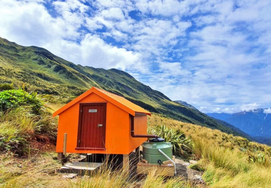
The original Scottys Biv was an NZFS B49 design built in 1958 by the late Alan Farmer from Rotorua. The materials were dropped from a Dominie aircraft with wing racks and Alan wrote about this in his book "The Best Job Ever." It flat-iron walls and roof and a single perspex window at the far end. Its interior was furbished with a cooking bench and two sleeping platforms which were most likely retrofitted in the early 1970's. The new Biv is a lined B55 replica with a single pane glass end window. It is more spartan on the inside than the old Biv with no sleeping platforms or benches (there are a couple foam of sleeping mats provided). It has a roof fed water tank. There is no toilet.
Condition
The new Scottys Biv is in mint condition currently.
Scottys Biv was designated for removal in a review that the Department of Conservation carried out in 2004. This was due to its low level of use and poor condition. Then interestingly they went in and did some maintenance on it. The Permolat Group got involved in 2006 and I signed our first maintain-by-community contract with the Department. This was a forerunner to a number of other similar agreements and when the contract expired in 2016 Scottys was added to the more general region-wide agreement we had by that stage. Low-level maintenance was carried out over the years by volunteers but by 2021 the Biv was starting to deteriorate. At the end of 2021 the DOC Hokitika carpenters started banging together a brand new biv down at their workshop. In March this year this was flown in to replace the old one. Helicopter costs were covered by the BCT. Permolat made use of the machine to backload a team in to work on the access routes at the end of the Tara Tama Range and from Griffin Creek.
Location
Taipo catchment. Map BV20. Grid Ref: E1470151/ N5259403 (BV20 702 594). Altitude 1050m. Scottys Biv is located amid scattered alpine scrub on a bench in the headwaters of Scottys Creek. A couple of reasonable-sized tarns close by and great views out over the Taipo valley and of the impressive northern buttresses of Tara Tama. Scottys Creek is impassable and so access to the Biv is exclusively via the tops. It is a moderate-hard overnighter and often port of call on longer tops journeys. Prior to its adoption Scottys was being visited once every 3-5 years. A record 10 visits were recorded in 2005 following its initial profiling on this website. Two more bumper years followed in 2016 and 2017 (eight parties each), but since then it's fallen back to 3-4 visits per year.
Access
The most direct route to Scottys Biv is via an old NZFS tops track that starts opposite Seven Mile Creek in the Taipo valley. This was last given a tidy-up in March 2022 and is in reasonably good shape. The access road up the TR of the Taipo to Seven Mile Creek from SH73 has been steadily deteriorating over the years, particularly the section up and around the back of Point 338m. Unless you have a high stud 4WD, a six km walk or bike ride from the DOC carpark next to the highway is necessary. The farm track ends at Seven Mile Creek where the landowner currently has two or three diggers doing extensive gold excavation work. The track entrance is roughly 500m downstream of the Seven Mile on the TL of the Taipo. There isn't a particularly good ford here at the moment and crossings should definitely not be attempted when the river is up. It may be necessary to go downstream a fair distance currently to find a safer ford.
The track commences at the mouth of a small side-creek that enters the River just below some shingle bluffs and is marked with a cairn and permolat. Follow the creek up for 100m to where a track exits on the TR and climbs steeply up onto a bush terrace. This is followed at a fairly gentle gradient above the TR of the creek to a broad spur which is steep initially and becomes better-defined around the 850m mark. A plastic water drum at 950m and a smaller 20 litre container at the bush edge provide the only water for a considerable distance. There are a couple of small but easy to miss tarns along the crest of the Range and one just before Scottys Saddle. From the top of the track the route continues through scattered scrub onto point 1371m and along the crest of the range over a second point 1371m to point 1399m. The Biv comes into view here but a direct line to it isn't possible due to some obscured bluffs and scrub gullies. Continue instead along the Range until 200m past the low point between points 1399m and 1406m from where it is possible to descent diagonally towards the Biv at a bearing of roughly 160 degrees. Alternately continue along the Range to point 1406m where waratahs and cairns lead in a SE direction straight down the tussock faces to the Biv. A fit, experienced party should be able to reach the Biv in 6-7 hours from the Seven Mile. Good visibility or GPS is essential for this route.
Another commonly used route to Scottys is from the Griffin Creek catchment. The Biv can be accessed up the second side-creek downstream from Griffin Creek Hut. The route follows the Rocky Creek saddle track initially but leaves it where crosses to the TR of the creek. Continue up the creek from here. Travel is straightforward initially, but gets progressively steeper and rougher further up, with a set of waterfalls from around the 1000m contour. There is a short length of rope to assist getting around the first, a steep scrub detour on a side ridge on the TL cut in March 2002 to get you around the second two, and a short cut detour through the alpine scrub on its TR for the fourth. After this the creek opens up a bit and eventually peters out. Climb out of the creek around the 1320m contour and head up a scree towards the obvious low point in the range (E1469280/ N5259365 (BV20 693 594)). A large boulder with a cairn on top marks this unnamed saddle which lies 200m South of Scottys Saddle. Scottys Biv is accessed by following the waratahs down from point 1406m. Allow four hours from Griffin Creek Hut to Scottys Biv, or a long day (8-10 hours) from the Griffin roadend at Harrington Creek on SH73.
Type
The original Scottys Biv was an NZFS B49 design built in 1958 by the late Alan Farmer from Rotorua. The materials were dropped from a Dominie aircraft with wing racks and Alan wrote about this in his book "The Best Job Ever." It flat-iron walls and roof and a single perspex window at the far end. Its interior was furbished with a cooking bench and two sleeping platforms which were most likely retrofitted in the early 1970's. The new Biv is a lined B55 replica with a single pane glass end window. It is more spartan on the inside than the old Biv with no sleeping platforms or benches (there are a couple foam of sleeping mats provided). It has a roof fed water tank. There is no toilet.
Condition
The new Scottys Biv is in mint condition currently.
 Route onto Scottys Range from the head of Rocky Creek
Routes
Scottys Biv can be accessed from Rocky Creek Biv from the head of Rocky Creek. The Creek is followed up past the Griffin saddle turnoff. It narrows considerably, needs to be waded, is steep and slippery in places. At around 1100m it forks and the TL fork is followed. It steepens and eventually peters out on a steep scree. Climb onto the spur above the scree and continue up through a narrow band of low alpine scrub and across a rockfield towards the crest of the Range. The faces directly above this are very steep and it is easier to sidle SW over a narrow ridge and then climb up onto the crest from there. The last pitch is very steep tussock. From the crest it is a straightforward 20 minute drop in a SE direction to Scottys Biv which is visible from near the top. Allow 2.5-3 hours from Rocky Creek Biv to Scottys Biv. Allow 3-4 hours to get from Rocky Creek Biv to Scottys Biv.
Newton Creek Hut in the Arahura can be accessed via Newton Creek basin and the col between points 1516m and 1751m. Travel is easy in the upper reaches of the Creek, but it gets rougher a bit further down the odd short scrub detour may be required The last section before the Hut is quite bouldery and it is necessary to sidle above the Creek on the TR for this. Fortunately the forest here is not too bad to get through. Allow 4-5 hours for the crossing from Scottys to Newton Creek Hut.
 The Dunns Saddle route from Scottys
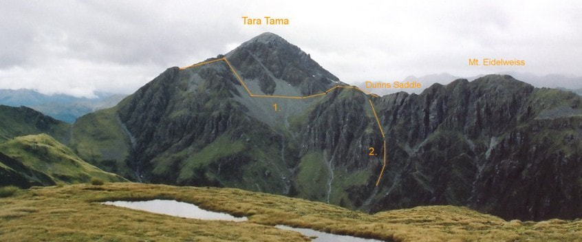
Dunns Hut can be accessed either via Dunns Saddle and the Tara Tama Range, or directly over the Top of Tara Tama. The Dunns Saddle route involves a sidle across a steep scree from the NW shoulder of the low peak of Tara Tama. Sidle back across to the main ridge aiming for the small knob just north of Dunns Saddle. This avoids a steep section of ridge between Tara Tama and Dunns Saddle. Travel down Dunns Creek from the Saddle is straightforward, although there is some avalanche risk from the Tara Tama side after heavy snowfalls.
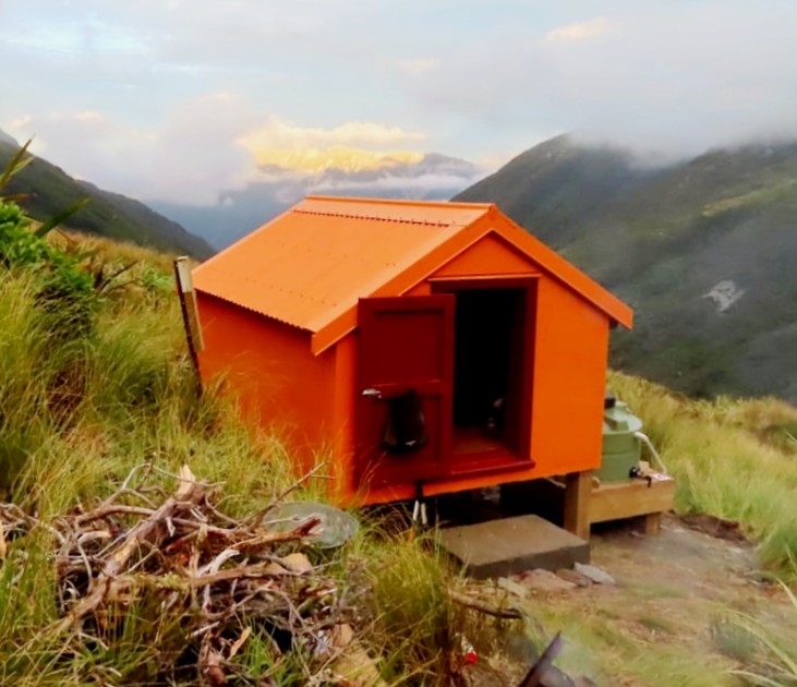
The Tara Tama traverse can be done either by climbing up to Scottys Saddle and following the crest of the Tara Tama Range, or by dropping directly into Scottys Creek from the Biv and climbing up onto the summit ridge from there. The open side-creek directly opposite the Biv visible in the larger hut photo provides the best access. A short scrub-bash is required to get down into Scottys Creek and a waterfall at the lower end of the access creek can be skirted on the TL through patchy scrub and large boulders. Take the TR fork of the creek at the 1100m contour and continue up to around 1400m, then exit on the TL and climb the scree or snow slopes onto the ridge between Tara Tama and point 1751m. Drop from the Tara Tama's summit down its broad SE spur to around E1471242/ N5257261 (BV20 712 572) where a cairn marks drop-off into Dunns basin. A steep tussock face provides access into an open gut that enters Dunns Creek 20 minutes upstream of the Hut. The gut is easy travel when snow free, but in the colder months is an active avalanche chute and should be avoided after heavy snowfalls.
Top Olderog Biv can be accessed from Scottys Biv via the Tara Tama Range. Once on the crest of the Range, it's an easy traverse around to point 1566m. A traverse from here along the McArthur Range to the Biv is not recommended due to it having a number of exposed, vertical sections. A more pleasant option is to drop into the head of the head of Olderog Creek and climb back onto the McArthur Range further down the valley. Access down into Olderog Creek is from the col between point 1566m and Mt. Olson. A steep narrow rock gut takes you into the head of Olderog Creek which is then followed. There are a couple of small cascades to negotiate, the longest of which can be skirted on a smooth-rock ledge on its TR. Exit the Olderog at a small side-creek that comes in on the TR at E1464688/ N5257080 (BV19 647 571). Climb up the side-creek, then some steepish tussock ribs to around 1250m, then sidle downriver to the bench where the Biv is located. You'd be looking at 5-6 hours in good conditions to get from Scottys to Top Olderog. There is purportedly a rock biv somewhere in the head of Olderog Creek, but no information on hand about its exact location, size, or suitability.
Access into the upper Wainihinihi basin is down a prominent spur that drops in a NW direction from the Range 500m SW of point 1572m. Don't drop all the way into Wainihinihi Creek, as there is a small canyon in its head at around 1000m. Instead sidle off the spur and across the tussock terraces on the TL of the valley at around 1050m. Cross a small side-creek around E1465798/ N5258420 (BV19 658 584) and continue sidling into the next creek catchment. Access is down a series of smooth rock chutes in the creek bed to the Wainihinihi, then downriver to the large open flat in the upper basin. There are plenty of great camping spots here and no obvious signs of human visitation.
Razorback Ridge is aptly named and is not traversable without climbing gear, however it is possible to sidle under the troublesome section on the Wainihinihi side. This requires dropping from point 1572m into the head of Wainihinihi Creek, then sidling out on the TR along the 1060m contour to the forks of the unnamed side-creek further along (at E1465628/ N5258785 (BV19 656 588)). Head up the dividing ridge between this side-creek and the next one downriver, onto the Mt. Griffin tops. From here it's an easy couple of hours in good conditions down to the start of the Wilson Knob track. The track down through the alpine scrub to the Griffin Creek turn-off starts a couple of hundred metres NE of point 1126m at GPS Ref: E1467135/ N5261729. The track was recut by Permolat volunteers in January 2021.
Although Scottys Creek looks reasonably benign from the Biv it is not apparently, recommended as a route down to the Taipo valley. The only account I've been provided is one from 35 years ago which describes it as an horrendous 14-hour scrub-bash.
Repairs needed.
Nil currently. A couple of mattresses would be a welcome addition.
Provisions on site
A shovel small billy, a frypan, a hammer, a tenon saw, an aluminium bucket and wash basin, a few 50mm flathead nails, a hand brush a phillips screwdriver, some duct tape, a large paint brush, and a small amount of Rescue Orange paint in a 10 litre container.
