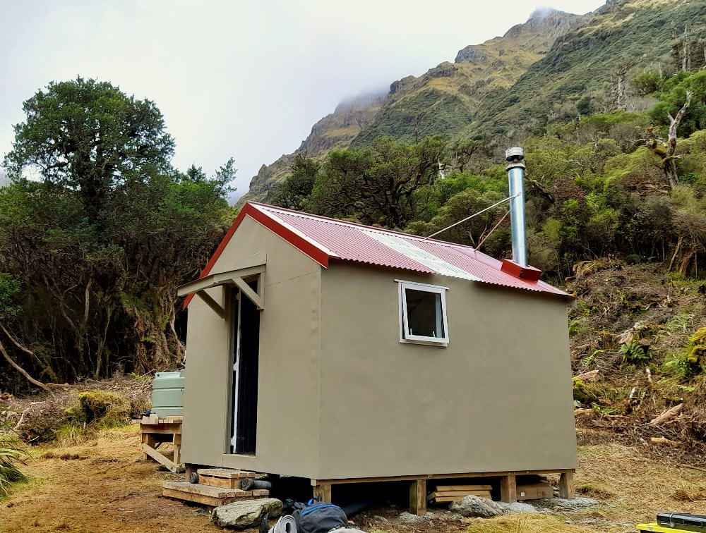
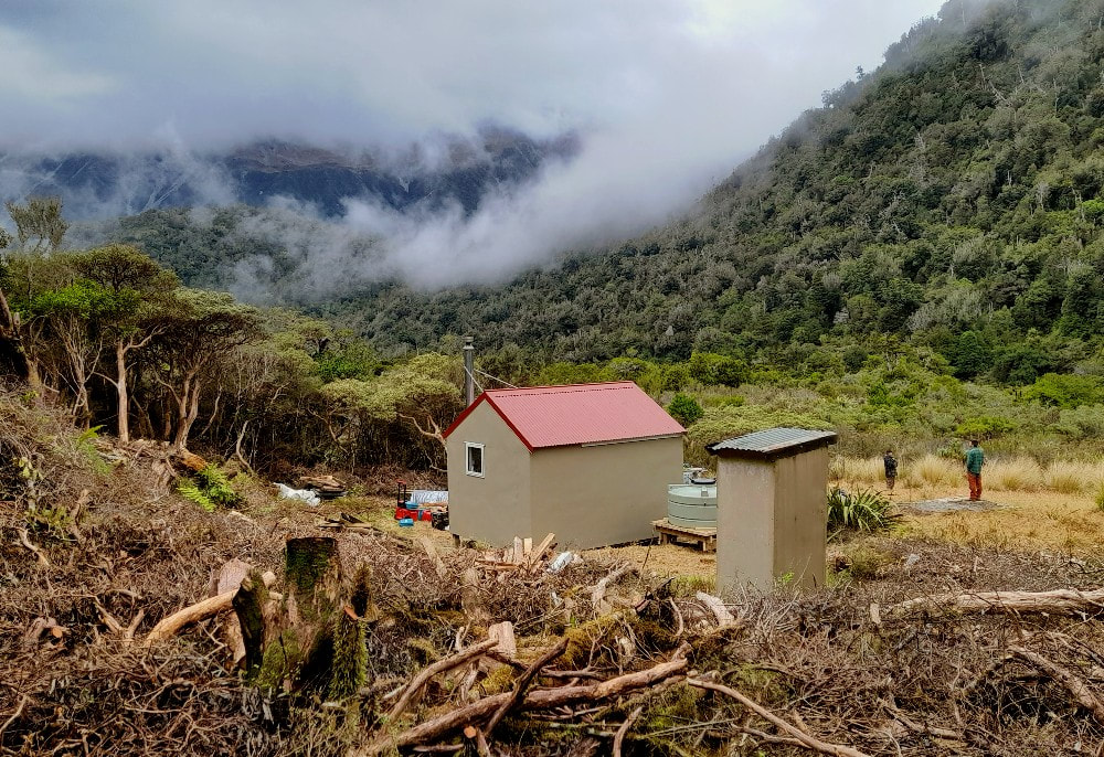
Dunns Creek Hut
 Tara Tama and Dunns Saddle routes
Maintenance Status
Dunns is designated as a DOC fully maintain hut however from the early 2000's onward it only received minimal attention and gradually became run down and rat infested. In 2023 Back Country Trust used some of its remaining Jobs for Nature funding to do a major overhaul which turned into a rebuild due to the poor condition of the hut's piles and sub-floor. A new frame was pre-built by the DOC Hokitika carpenters and flown to the site and a team of BCT carpenters and workers did the rest.
Dunns forms part of a DOC maintained circuit from the Arahura valley. The tracked sections of the route from Mid Taipo Hut and Newton Creek in the Arahura were recut in 2021. An old NZFS route up the TL of Dunns Creek from the Taipo valley was opened up some time back by Permolat volunteers, was partially retrimmed in 2023, but needs some finishing off work.
Location
Taipo catchment. Map BV20. Grid Ref: E1471566/ N5256348 (BV20 716 563). Altitude 705m. Dunns Hut is located in the mid-section of Dunns Creek at the edge of an open marshy area. The basin is ringed by the peaks of the Campbell and Tara Tama Ranges and downstream from the Hut the Creek drops through a steep gorge with waterfalls before flattening and flowing into the Taipo River. Dunns can be accessed in a day from the Taipo roadend by an averagely fit party. A good portion of the Hut's visitors are doing the Newton Saddle circuit from Newton Creek Hut in the Arahura valley. Dunns is a great location just to hang out and relax, and a climb of Tara Tama makes for a good day outing. Visits have been steadily increasing over the past three years from around 20 to a record 36 in 2022.
Access
The access road up the TR of the Taipo to Seven Mile Creek from SH73 has been steadily deteriorating over the years, particularly the section up and around the back of Point 338m. Unless you have a high stud 4WD a six km walk or bike ride from the DOC carpark next to the highway is necessary. The farm track ends at Seven Mile Creek where the landowner currently has two or three diggers doing extensive gold excavation work. Dillon's Homestead and Dillon Hut are located on the TL of Seven Mile Creek which can be difficult to ford after heavy rain. A track leads from there up the TR of the valley to a three-wire above Scottys Creek. The main valley route crosses to the TL here followed by a short steep climb around a bluff. This can be avoided when the river is low by staying on the TR and fording further upstream. Fords can be found below and above Hunts Creek currently and offer a quicker and more direct line. This shouldn't be attempted however if the river is up. It's also worth noting that the fording conditions change regularly, so you are taking a bit of a punt in finding a good crossing.
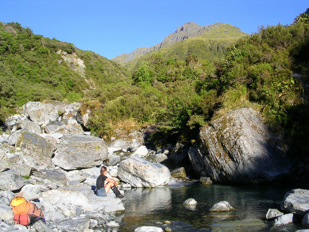
Travel on the TL is up a series of grassy flats to Dunns Creek, then boulderhopping up Dunns, mostly on its TL. Several crossings to the TR are options if you want to get a quicker line. One is necessary at a prominent bend in the Creek to bypass a rock outcrop. The TL track around the Dunns gorge starts where the Creek becomes obviously steep and bouldery (around E1472576/ N5256503 - BV20 726 565). It continues parallel to the Creek for 40 metres then veers West up an open slip with dead-standing trees. The track re-enters the bush 500m up the slip on the TR, just behind a large boulder with a cairn on top. It climbs steeply up the faces onto the ridge bounding the gorge and follows this up a short distance before sidling off into Dunns basin. The Hut is tucked against the side of the hill a couple of hundred metres upriver from where the track emerges into a marshy clearing. The track was partially trimmed in 2023 and is still pretty easy to follow. Allow around 3-4 hours currently from Dillon Hut to Dunns Hut using this route.
The DOC maintained route to Dunns Hut from Mid Taipo Hut starts at the bottom end of the river flat below Hura Creek. A track enters the bush here, climbs up a steep gut, and over a low bush saddle into Dunns basin. The saddle section is an easy amble through beautiful montane forest, followed by a gentle drop into Dunns basin. This track was recut in 2021. Travel time to Dunns from Mid Taipo Hut is around two hours.
The route over Newton Saddle to Newton Creek Hut goes up Dunns Creek. The tracked sections below the bushline were recut by DOC in 2021. The route above the bushline on both sides of the Saddle is poled. Those with experience in the remote huts zone should allow around five hours for the crossing in good conditions. Snow may slow things considerably in the colder months and the top of the Newton Creek side of the Saddle may require ice axes at certain times. The creek that provides access up from the Newton Creek side gets no sun in the winter and the rocks are often icy. Many parties are taking much longer than the recommended track times and the hutbook is full of moans about how tough the route, and how shitty the track is. In my estimation this crossing is no more difficult than similar alpine saddles in the area. The tracked bits are actually OK given the roughness of the terrain and the comments more a reflection of the inexperience and unrealistic expectations of those doing it.
Type
Dunns was a NZFS S81, four-bunk design built in the early 1960's. An open fire was removed quite early on and replaced with a wood burner. The Hut was lined and had a roof-fed water tank and toilet added. At some point one of the cupboards next to the door was removed to create more space. The renovated hut keeps reasonably true to the old template but is strengthened to meet current building standards. The original louvre windows have been replaced with single pane double glazed ones. The new wood burner has been shifted to the NE corner and there is no cupboard area in the new structure, creating more space.
Condition
The original Dunns was repainted, resealed, had some piles, framing, skylights, and flue replaced in the summer of 2004. Some repairs to the door and frame were made in 2013. The Hut's woodburner amazingly didn't have an outer flue sleeve. Unsurprising then that the rubber boot on the roof eventually melted and let the weather in. When the Hut lining was stripped away in 2023 it was discovered that most of original rimu framing was rotten. Plans by the BCT crew led by Clint Jarvis to build from the floor up were shelved when it was found to be in too poor a condition and the project ended up being a total rebuild. The new structure is sound, weatherproof, and very cosy with the new burner. The interior finishing work and external painting was completed in April and a new water tank and stand were installed. A woodshed was built with leftover timber and old roofing iron. The toilet is still the original version has some dry rot in a couple of its dwangs.
Routes
A traverse of Mt Edelweiss from Dunns Saddle to Newton Saddle makes for an interesting side, or daytrip, in good conditions. Travel up the TL branch of Dunns Creek to Dunns Saddle is relatively easy, although there is potential avalanche danger from Tara Tama after heavy snowfalls. The section of tops over Mt Edelweiss to Newton Saddle is fairly gentle. and it is possible to access Newton Creek basin from Dunns Saddle down a steep scree and rock gut. Travel down Newton Creek from the upper basin to the Hut is OK, although a bush-bash is required on the TR of a bouldery cascade a short distance above the Hut. The forest here isn't too bad if you pick the right line. More time and higher skill levels are required for the Dunns Saddle route.
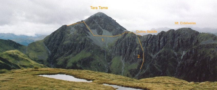
A high-level traverse can be done from Dunns Hut to Scottys Biv over Tara Tama. Access is up an open gut 20 minutes up Dunns Creek, around E1471066/ N5256463 (BV20 711 565). The gut turns into an active avalanche chute after heavy snowfalls and should probably be avoided during the colder months. Nevertheless it provides rapid access up onto a broad tussock spur with spectacular rock outcrops, and from here it's a straightforward rock scramble up to the summit of Tara Tama. The traverse to Scottys Saddle along the crest of the Range is straightforward and it is 20 minutes descent down reasonably gentle tussock faces to the Biv which is visible for most of the traverse.
It is also possible to drop directly down to the Biv from the ridge between the high and low peaks of Tara Tama. This is down some steepish rock guts and screes into the open creek bed further down. A waterfall near the bottom of the creek can be negotiated on the TL, after which there is a short uphill scrub-bash from Scottys Creek onto the bench where the Biv is located.
Scottys can be accessed from Dunns Saddle by heading North over a couple of small knobs to a dip just before where the ridge becomes vertical. It is necessary to sidle off the main ridge here on the Newton Creek side, across and up a scree to a dip on the western ridge of Tara Tama just below point 1751m. Continue down from here to the crest of the Tara Tama Range and along to Scottys Saddle. Ice axes and crampons may be necessary for the traverses in winter and spring.
Griffin Creek Hut has historically been accessed from Dunns using the Scottys route by dropping from the unnamed saddle 200m South of Scottys Saddle, which has a large boulder with a cairn on top of it. A steep scree leads into the unnamed creek below, and this is followed down into the Griffin. A waterfall in the alpine scrub zone can be skirted on the TR. At around the 1000m contour there is another set of waterfalls which up until recently could be downclimbed. Changes to the streambed have mad this impossible leaving the choice of using a rope or climbing out of the creek on the TL onto a steep side-ridge with very thick alpine scrub and dropping down this. Further down the creek flattens somewhat and the going gets easier. The Rocky Creek track crosses the creek about 400m above its confluence with the Griffin. Follow this down the TL to where it connects with the main valley track 20m above Griffin Creek. From here it is around 15 minutes upriver to the Hut.
Work still to take place.
The rotten dwangs in the toilet need replacing. The track up the TL of the gorge needs trimming in the places that haven't yet been done.
Provisions on Site
Hut provisions comprise an axe, an aluminium basin, a bow saw, a broom, a stainless-steel bucket, two metal stools carried in by some appreciative Dutch visitors, a shovel head, and a hearth shovel. There is a small quantity of nails and permolat.
Dunns is designated as a DOC fully maintain hut however from the early 2000's onward it only received minimal attention and gradually became run down and rat infested. In 2023 Back Country Trust used some of its remaining Jobs for Nature funding to do a major overhaul which turned into a rebuild due to the poor condition of the hut's piles and sub-floor. A new frame was pre-built by the DOC Hokitika carpenters and flown to the site and a team of BCT carpenters and workers did the rest.
Dunns forms part of a DOC maintained circuit from the Arahura valley. The tracked sections of the route from Mid Taipo Hut and Newton Creek in the Arahura were recut in 2021. An old NZFS route up the TL of Dunns Creek from the Taipo valley was opened up some time back by Permolat volunteers, was partially retrimmed in 2023, but needs some finishing off work.
Location
Taipo catchment. Map BV20. Grid Ref: E1471566/ N5256348 (BV20 716 563). Altitude 705m. Dunns Hut is located in the mid-section of Dunns Creek at the edge of an open marshy area. The basin is ringed by the peaks of the Campbell and Tara Tama Ranges and downstream from the Hut the Creek drops through a steep gorge with waterfalls before flattening and flowing into the Taipo River. Dunns can be accessed in a day from the Taipo roadend by an averagely fit party. A good portion of the Hut's visitors are doing the Newton Saddle circuit from Newton Creek Hut in the Arahura valley. Dunns is a great location just to hang out and relax, and a climb of Tara Tama makes for a good day outing. Visits have been steadily increasing over the past three years from around 20 to a record 36 in 2022.
Access
The access road up the TR of the Taipo to Seven Mile Creek from SH73 has been steadily deteriorating over the years, particularly the section up and around the back of Point 338m. Unless you have a high stud 4WD a six km walk or bike ride from the DOC carpark next to the highway is necessary. The farm track ends at Seven Mile Creek where the landowner currently has two or three diggers doing extensive gold excavation work. Dillon's Homestead and Dillon Hut are located on the TL of Seven Mile Creek which can be difficult to ford after heavy rain. A track leads from there up the TR of the valley to a three-wire above Scottys Creek. The main valley route crosses to the TL here followed by a short steep climb around a bluff. This can be avoided when the river is low by staying on the TR and fording further upstream. Fords can be found below and above Hunts Creek currently and offer a quicker and more direct line. This shouldn't be attempted however if the river is up. It's also worth noting that the fording conditions change regularly, so you are taking a bit of a punt in finding a good crossing.
Travel on the TL is up a series of grassy flats to Dunns Creek, then boulderhopping up Dunns, mostly on its TL. Several crossings to the TR are options if you want to get a quicker line. One is necessary at a prominent bend in the Creek to bypass a rock outcrop. The TL track around the Dunns gorge starts where the Creek becomes obviously steep and bouldery (around E1472576/ N5256503 - BV20 726 565). It continues parallel to the Creek for 40 metres then veers West up an open slip with dead-standing trees. The track re-enters the bush 500m up the slip on the TR, just behind a large boulder with a cairn on top. It climbs steeply up the faces onto the ridge bounding the gorge and follows this up a short distance before sidling off into Dunns basin. The Hut is tucked against the side of the hill a couple of hundred metres upriver from where the track emerges into a marshy clearing. The track was partially trimmed in 2023 and is still pretty easy to follow. Allow around 3-4 hours currently from Dillon Hut to Dunns Hut using this route.
The DOC maintained route to Dunns Hut from Mid Taipo Hut starts at the bottom end of the river flat below Hura Creek. A track enters the bush here, climbs up a steep gut, and over a low bush saddle into Dunns basin. The saddle section is an easy amble through beautiful montane forest, followed by a gentle drop into Dunns basin. This track was recut in 2021. Travel time to Dunns from Mid Taipo Hut is around two hours.
The route over Newton Saddle to Newton Creek Hut goes up Dunns Creek. The tracked sections below the bushline were recut by DOC in 2021. The route above the bushline on both sides of the Saddle is poled. Those with experience in the remote huts zone should allow around five hours for the crossing in good conditions. Snow may slow things considerably in the colder months and the top of the Newton Creek side of the Saddle may require ice axes at certain times. The creek that provides access up from the Newton Creek side gets no sun in the winter and the rocks are often icy. Many parties are taking much longer than the recommended track times and the hutbook is full of moans about how tough the route, and how shitty the track is. In my estimation this crossing is no more difficult than similar alpine saddles in the area. The tracked bits are actually OK given the roughness of the terrain and the comments more a reflection of the inexperience and unrealistic expectations of those doing it.
Type
Dunns was a NZFS S81, four-bunk design built in the early 1960's. An open fire was removed quite early on and replaced with a wood burner. The Hut was lined and had a roof-fed water tank and toilet added. At some point one of the cupboards next to the door was removed to create more space. The renovated hut keeps reasonably true to the old template but is strengthened to meet current building standards. The original louvre windows have been replaced with single pane double glazed ones. The new wood burner has been shifted to the NE corner and there is no cupboard area in the new structure, creating more space.
Condition
The original Dunns was repainted, resealed, had some piles, framing, skylights, and flue replaced in the summer of 2004. Some repairs to the door and frame were made in 2013. The Hut's woodburner amazingly didn't have an outer flue sleeve. Unsurprising then that the rubber boot on the roof eventually melted and let the weather in. When the Hut lining was stripped away in 2023 it was discovered that most of original rimu framing was rotten. Plans by the BCT crew led by Clint Jarvis to build from the floor up were shelved when it was found to be in too poor a condition and the project ended up being a total rebuild. The new structure is sound, weatherproof, and very cosy with the new burner. The interior finishing work and external painting was completed in April and a new water tank and stand were installed. A woodshed was built with leftover timber and old roofing iron. The toilet is still the original version has some dry rot in a couple of its dwangs.
Routes
A traverse of Mt Edelweiss from Dunns Saddle to Newton Saddle makes for an interesting side, or daytrip, in good conditions. Travel up the TL branch of Dunns Creek to Dunns Saddle is relatively easy, although there is potential avalanche danger from Tara Tama after heavy snowfalls. The section of tops over Mt Edelweiss to Newton Saddle is fairly gentle. and it is possible to access Newton Creek basin from Dunns Saddle down a steep scree and rock gut. Travel down Newton Creek from the upper basin to the Hut is OK, although a bush-bash is required on the TR of a bouldery cascade a short distance above the Hut. The forest here isn't too bad if you pick the right line. More time and higher skill levels are required for the Dunns Saddle route.
A high-level traverse can be done from Dunns Hut to Scottys Biv over Tara Tama. Access is up an open gut 20 minutes up Dunns Creek, around E1471066/ N5256463 (BV20 711 565). The gut turns into an active avalanche chute after heavy snowfalls and should probably be avoided during the colder months. Nevertheless it provides rapid access up onto a broad tussock spur with spectacular rock outcrops, and from here it's a straightforward rock scramble up to the summit of Tara Tama. The traverse to Scottys Saddle along the crest of the Range is straightforward and it is 20 minutes descent down reasonably gentle tussock faces to the Biv which is visible for most of the traverse.
It is also possible to drop directly down to the Biv from the ridge between the high and low peaks of Tara Tama. This is down some steepish rock guts and screes into the open creek bed further down. A waterfall near the bottom of the creek can be negotiated on the TL, after which there is a short uphill scrub-bash from Scottys Creek onto the bench where the Biv is located.
Scottys can be accessed from Dunns Saddle by heading North over a couple of small knobs to a dip just before where the ridge becomes vertical. It is necessary to sidle off the main ridge here on the Newton Creek side, across and up a scree to a dip on the western ridge of Tara Tama just below point 1751m. Continue down from here to the crest of the Tara Tama Range and along to Scottys Saddle. Ice axes and crampons may be necessary for the traverses in winter and spring.
Griffin Creek Hut has historically been accessed from Dunns using the Scottys route by dropping from the unnamed saddle 200m South of Scottys Saddle, which has a large boulder with a cairn on top of it. A steep scree leads into the unnamed creek below, and this is followed down into the Griffin. A waterfall in the alpine scrub zone can be skirted on the TR. At around the 1000m contour there is another set of waterfalls which up until recently could be downclimbed. Changes to the streambed have mad this impossible leaving the choice of using a rope or climbing out of the creek on the TL onto a steep side-ridge with very thick alpine scrub and dropping down this. Further down the creek flattens somewhat and the going gets easier. The Rocky Creek track crosses the creek about 400m above its confluence with the Griffin. Follow this down the TL to where it connects with the main valley track 20m above Griffin Creek. From here it is around 15 minutes upriver to the Hut.
Work still to take place.
The rotten dwangs in the toilet need replacing. The track up the TL of the gorge needs trimming in the places that haven't yet been done.
Provisions on Site
Hut provisions comprise an axe, an aluminium basin, a bow saw, a broom, a stainless-steel bucket, two metal stools carried in by some appreciative Dutch visitors, a shovel head, and a hearth shovel. There is a small quantity of nails and permolat.
