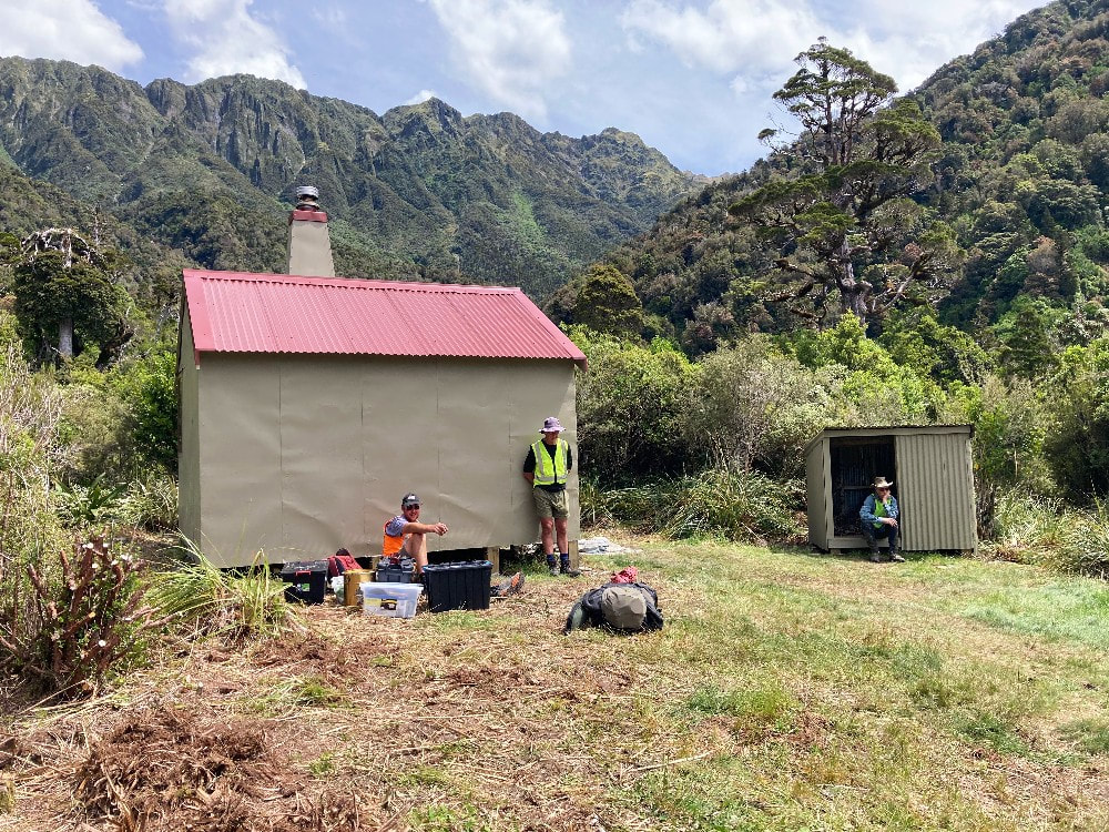
Griffin Creek Hut
 The Tara Tama - Dunns Saddle route to Dunns Hut
Maintenance Status
Griffin Creek Hut was designated by the Department of Conservation as fully maintain in 2003, but aside from some painting and resealing work in 2004, nothing more was done. The place was still in reasonable condition but getting a little run-down by 2023 when the Back Country Trust got involved and flew a team to do some comprehensive maintenance. The project was joint funded by Trust and the Federated Mountain Clubs Forest & Mountain Trust. Weather woes prevented completion of the work in November '23 and installation of a wood burner, completion of the piling, and exterior painting took place in January '24.
The access tracks into Griffin Creek haven't been officially maintained for 38 years but have been kept open and in reasonable condition by the outdoor community. Dave Evans of Christchurch has had regular input on the main access track from Harrington Creek on SH 73. In January 2021 a Permolat team led by Andrew Barker of Nelson recut sections of the track around Point 974m while doing some BCT funded work on the Wilson Knob track. More trimming work was done by volunteers in 2022 and in April this year Dave spent a couple of days working up to the 850m contour from Harrington Creek.
Location
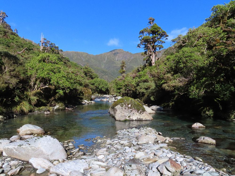
Taramakau catchment. Map BV20. Grid Ref: E1467740/ N5260395 (BV19 677 604). Altitude 665m. Griffin Creek Hut is located in the Griffin Creek basin around four hours walk from Harrington Creek Bridge on State Highway 73. The Hut is in a small clearing on a terrace next to Griffin Creek and is surrounded by montane forest with emergent pahautea (mountain cedar). Griffin Creek forks into several branches just upstream of the Hut and is negotiable for only a short stretch before becoming gorgy. The first section has a small waterfall and picturesque, amethyst pools that flow through water-sculpted rock. A 40m waterfall bars all progress a kilometre or so further upstream.
Griffin Creek drops from the end of the basin down through a slotted canyon with a 50m waterfall to the Taramakau River. A concession for a small 1.3MW hydro scheme on this section was granted in 2011. This would pipe water from an intake at the lip of the basin down to a small powerhouse near the Highway. It wouldn't have been visible from any of the routes to the Hut but would have reduced water flows considerably in the lower portion of the Creek. In 2018 the company applied to enlarge the scheme, attracting strong opposition from the NZ Canyoning Association who consider the lower Griffin to be one of Aotearoa's best trips. A legal challenge to the scheme by FMC was recently dismissed by the Court.
All the routes into the Griffin require a climb of some sort. The Hut makes for a great overnight trip and serves as a starting point for a number of longer tops crossings to remoter spots. It currently gets 10-20 visits per year.
Access
The Griffin Creek track starts on SH73 on the TL of Harrington Creek. You can legally park on an old section of highway in the paddock next to the Creek, however it's courteous to check in with the farmer just down the road before doing so. Go through the gate at the end of the old road and follow the outside of the fenceline up the hillside for 800m to where a track goes into the bush. This follows up the TL of Harrington Creek for 10 minutes, then crosses and begins a steep climb up the bush faces of the Griffin Range. The trail connects with the spur bounding Griffin Creek at around 740m and follows this up for half an hour to the Wilson Knob turn-off at point 974m. There is a small clearing here and the remains of a 44-gallon drum with a bit of water in it.
The Griffin Creek track drops due East from the turnoff down a steep side-ridge into the basin below. Once in Griffin Creek it's predominantly river travel for around an hour to the Hut. Numerous crossings of the Creek are required which are not usually a problem at normal flows. There are two short sections of track on the TR below and above the creek draining Rocky Creek Saddle. The track proper starts 30m up the creek that drains Scottys Saddle. From here it climbs at gentle gradient along the river terraces for 15-20 minutes to the Hut. Allow 4-5 hours to Griffin Creek Hut from the Highway.
The other commonly used route into Griffin Creek is from the Taipo valley over a low bush saddle near the head of Rocky Creek. The tracked sections of the route were kept open for many years by Frank King and Honora Renwick of Christchurch. More recently others, including Eigill Wahlberg, Peter Umbers and Peninsula Tramping Club have added their input, the last work being completed by Eigill in July '24.
From Rocky Creek Biv it is a mix of short, tracked sections and creek travel and some wading is required. Allow at least an hour to reach the start of the track up to the saddle, located on the TL just above a large open slip. It is a short, steep 10-minute climb to the saddle. On the Griffin side the TR fork of an unnamed side-creek is followed initially crossing over to the TL branch just above a small waterfall. Continue down the creek to where a track exits on the TL and crosses over a low ridge into the creek draining Scottys Saddle. It goes down its TR for 400m where it intersects with the Griffin Creek Hut track. The track from Griffin Creek up to Rocky Creek Saddle was recut by some DOC predator control workers in June 2024. Allow at least eight hours to Griffin Creek Hut from the Taipo bridge, or 3-4 hours from Rocky Creek Biv.
The scrub that had been encroaching the chopper pad at the hut site was cleared during the recent round of maintenance.
Type
Griffin Creek Hut is a standard New Zealand Forest Service S81 four bunk design with open fire, built in 1963. Its interior was lined sometime later. Water is from the small creek just past the toilet. There is a cast iron bathtub next to the river, about 100m from the Hut, and there's nothing quite like firing it up and sitting under the stars on a clear night.
Condition
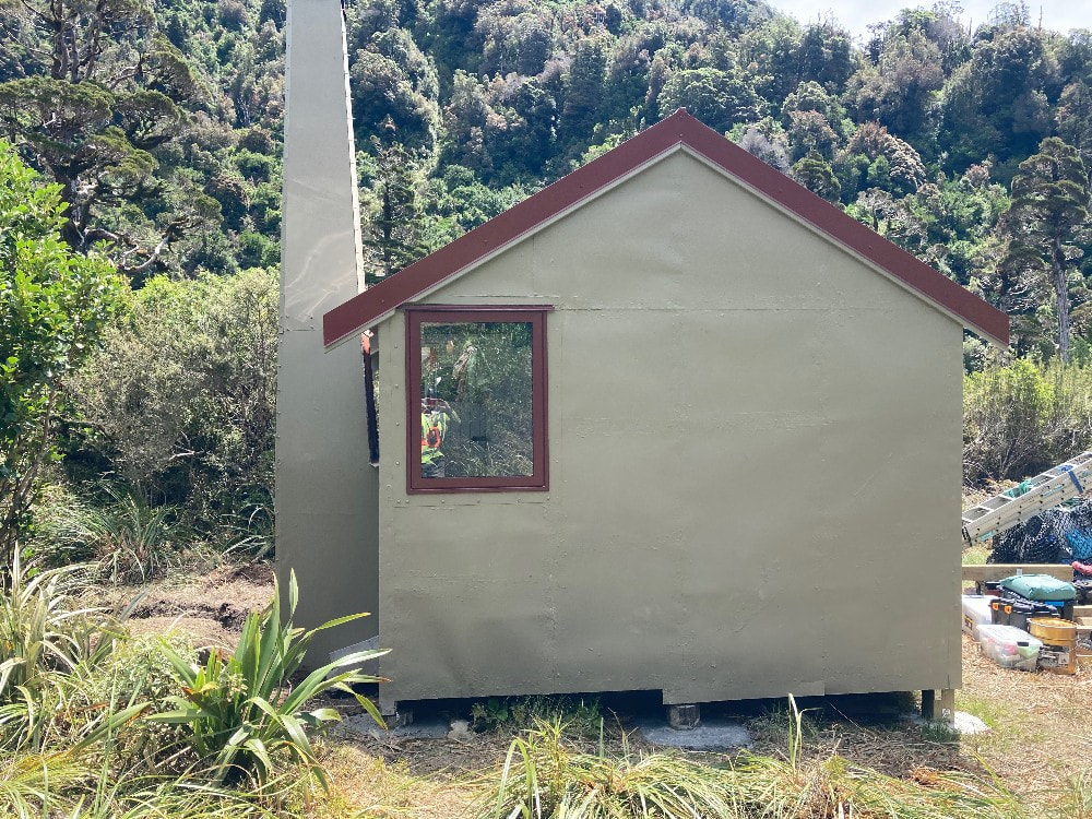
Griffin Creek Hut should be in great condition now. It was in reasonably good condition when BCT went in despite only having had minimal maintenance since the mid-1980s. This is partly due to it being adopted, provisioned, and lovingly maintained in the early 2000s by John Dainty and friends. A mining company dropped the bathtub for John down next to the creek. The BCT work in the summer of '23-'24 comprised roof replacement and replacement of the end window with a single pane one. New roof and window flashings were installed, some of the original piles were replaced and others reinforced, and a woodshed built. The hut exterior was painted, a woodburner installed in the existing fireplace, and a new doorstep built. A kea proof cover was affixed to the rubber flue flashing on the roof. The vegetation around the hut was cut back. There isn't a great deal of dry firewood around the hut site and most visitors aren't taking the time to forage further afield. The wood box usually has a few scraps of scrub tossed in to make it look good. Another form of disguised laziness.
Routes
An old NZFS track providing access to Wilson Knob and the Griffin Range branches off from the Griffin Creek track at point 974m. It was recut in 2021 and is in good condition. It follows an undulating ridgeline through scrub and open patches, before climbing and emerging in a shallow gully at GPS Ref: E1467135/ N5261729, just below point 1126m. There is a small depression to the east of the point with a sheltered campsite and some small tarns. The ridge is followed from here up through a narrow band of scrub between the 1130 and 1160m contours to Wilson Knob. The scrub here has been roughly cut and cruise taped. The remnants of a pre-WWI serpentine mine and cableway can be found further up the Range on the flanks of Mt. Griffin. The serpentine was sawn into slabs and used in several major buildings such as the D.I.C. Building in Dunedin, and the National Insurance Building in Christchurch. The quarry closed in 1915 but was re-opened briefly in 1991 by South Pacific Resources Ltd. to produce tiles. There is a breathtaking drop-off on the Little Wainihinihi side of the Range.
Scottys Biv can be accessed up the second side-creek downstream from Griffin Creek Hut. The route follows the Rocky Creek saddle track initially but leaves it where crosses to the TR of the creek. Continue up the creek from here. Travel is straightforward initially, but gets progressively steeper and rougher further up, with a set of waterfalls from around the 1000m contour. There is a short length of rope to assist getting around the first, a steep scrub detour on a side ridge on the TL cut in March 2002 to get you around the second two, and a short cut detour through the alpine scrub on its TR for the fourth. After this the creek opens up a bit and eventually peters out. Climb out of the creek around the 1320m contour and head up a scree towards the obvious low point in the range (E1469280/ N5259365 (BV20 693 594)). A large boulder with a cairn on top marks this unnamed saddle which lies 200m South of Scottys Saddle. Scottys Biv is accessed by following the waratahs down from point 1406m. Allow four hours from Griffin Creek Hut to Scottys Biv or a long day (8-10 hours) from the Griffin roadend at Harrington Creek on SH73.
Newton Creek basin and Newton Creek Hut can be accessed from a number of points on the Tara Tama Range. There are numerous lines down the tussock faces or ridges. The upper basin is open tussock and easy travel. Further down in the alpine scrub zone it pays to stick to the creekbed as much as possible. A scrub-bash through montane forest on the TR is required to skirt a bouldery section of the Creek not far above the Hut. This isn't too bad if you pick the right line. Allow 5-6 hours from Griffin Hut to Newton Creek Hut.
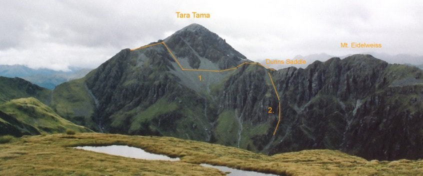
Dunns Hut in the Taipo can be accessed from Griffin Creek via the Scottys Biv route and the Tara Tama Range. This is a relatively easy route when the mountain is snow-free with some nice tarns and campsites SW of point 1516m. Drop eastwards from Tara Tama's summit onto a flat rocky bench at around the 1650m mark. Head SE from here and drop off the bench into a scree gut bounded by large and spectacular rock outcrops that leads onto a broad spur bounding Dunns Creek. Access from the spur into Dunns basin is down an open gut that enters Dunns Creek 20 minutes upstream of the Hut, at E1471066/ N5256463 (BV20 711 565). There is a cairn at the top of the drop-off, and a steep tussock face provides access into the gut, which is easy open travel. In the colder months the gut works as an avalanche chute and should be avoided after heavy snowfalls.
It is also possible to access Dunns Hut from the Griffin via the Tara Tama Range, Dunns Saddle, and the upper TL branch of Dunns Creek. A steep section of the Range immediately above Dunns Saddle can be avoided by dropping from the bench NW of point 1751m and sidling across a steep scree on the Newton Creek side. Sidle at around the 1520m contour and back onto the main ridge just above Dunns Saddle. Travel down the TL Branch of Dunns to the Hut is usually straightforward, although there is some avalanche risk in the head of the Creek head from the Tara Tama side after heavy snowfalls. Ice axes (and possibly crampons) may be necessary on both traverses during the colder months.
Top Olderog Biv can also be accessed from the Griffin via the Scottys Biv route and the Tara Tama Range. Once on the crest of the Range, it's an easy traverse around to point 1566m. A traverse from here along the McArthur Range to the Biv is not recommended due to it having a number of exposed, vertical sections. A more pleasant option is to drop into the head of the head of Olderog Creek and climb back onto the McArthur Range further down the valley. Access down into Olderog Creek is from the col between point 1566m and Mt. Olson. A steep narrow rock gut takes you into the head of Olderog Creek which is then followed. There are a couple of small cascades to negotiate, the longest of which can be skirted on a smooth-rock ledge on its TR. Exit the Olderog at a small side-creek that comes in on the TR at E1464688/ N5257080 (BV19 647 571). Climb up the side-creek, then some steepish tussock ribs to around 1250m, then sidle downriver to the bench where the Biv is located. You'd be looking at an 8-9 day in good conditions to get from the Griffin to Top Olderog. There is purportedly a rock biv somewhere in the head of Olderog Creek, but no information on hand about its exact location, size, or suitability.
Access into the upper Wainihinihi basin is down a prominent spur that drops in a NW direction from the Range 500m SW of point 1572m. Don't drop all the way into Wainihinihi Creek, as there is a small canyon in its head at around 1000m. Instead sidle off the spur and across the tussock terraces on the TL of the valley at around 1050m. Cross a small side-creek around E1465798/ N5258420 (BV19 658 584) and continue sidling into the next creek catchment. Access is down a series of smooth rock chutes in the creek bed to the Wainihinihi, then downriver to the large open flat in the upper basin. There are plenty of great camping spots here and no obvious signs of human visitation.
Scottys Range can be traversed from Scottys Saddle and is quite easy travel in good conditions. An old NZFS tops at the end of the Range provides access down to the Taipo valley just below Seven Mile Creek. Its top entrance is on the scrubline around E1473975/ N526143 (BV20 740 614) the track has been kept in useable condition by the Permolat Group. It was last given a trim and some marking in 2015 and should still be reasonably easy to follow. A ford of the Taipo is required at the bottom, making it a fine weather only route. There used to be quite a good one where the track hits the river, but apparently this has all changed and it may be necessary to head up or downriver to find a suitable crossing. Water needs to be carried from Scottys Saddle onward, as there is no reliable source until a rusting drum at 950m on the tops track. Allow 8-9 hours from Griffin Creek to Seven Mile Creek.
Razorback Ridge in the head of the Griffin is true to its name and not traversable without ropes according to the few who have passed this way. It is possible to sidle beneath the troublesome section on the Wainihinihi side. The approach from the Tara Tama Range is down the ridge SW of point 1572m, then into the head of Wainihinihi Creek. Sidle out of the Creek on the TR and head along the 1060m contour to the fork in the first side-creek downvalley (E1465628/ N5258785 (BV19 656 588)). Climb the dividing ridge between this and the next creek downriver, onto the Griffin Range West of point 1491m. It is easy tops travel from here around to Wilson Knob. The top entrance of the track down to the Griffin Creek track is a couple of hundred metres NE of point 1126m at GPS Ref: E1467135/ N5261729.
Repairs needed.
None Currently.
Provisions on Site
Six billies, two small frypans, a camp oven, an axe, a bow saw, an aluminium basin, two buckets, blankets, multiple utensils, nails, a roll of permolat, sealant, a sealant gun, flat files of various gauges, a wire brush, a sledgehammer, a hammer, a slasher, a pruning saw, a shovel, tins and buckets of paint, and 10 spare glass louvre panes.
Griffin Creek Hut was designated by the Department of Conservation as fully maintain in 2003, but aside from some painting and resealing work in 2004, nothing more was done. The place was still in reasonable condition but getting a little run-down by 2023 when the Back Country Trust got involved and flew a team to do some comprehensive maintenance. The project was joint funded by Trust and the Federated Mountain Clubs Forest & Mountain Trust. Weather woes prevented completion of the work in November '23 and installation of a wood burner, completion of the piling, and exterior painting took place in January '24.
The access tracks into Griffin Creek haven't been officially maintained for 38 years but have been kept open and in reasonable condition by the outdoor community. Dave Evans of Christchurch has had regular input on the main access track from Harrington Creek on SH 73. In January 2021 a Permolat team led by Andrew Barker of Nelson recut sections of the track around Point 974m while doing some BCT funded work on the Wilson Knob track. More trimming work was done by volunteers in 2022 and in April this year Dave spent a couple of days working up to the 850m contour from Harrington Creek.
Location
Taramakau catchment. Map BV20. Grid Ref: E1467740/ N5260395 (BV19 677 604). Altitude 665m. Griffin Creek Hut is located in the Griffin Creek basin around four hours walk from Harrington Creek Bridge on State Highway 73. The Hut is in a small clearing on a terrace next to Griffin Creek and is surrounded by montane forest with emergent pahautea (mountain cedar). Griffin Creek forks into several branches just upstream of the Hut and is negotiable for only a short stretch before becoming gorgy. The first section has a small waterfall and picturesque, amethyst pools that flow through water-sculpted rock. A 40m waterfall bars all progress a kilometre or so further upstream.
Griffin Creek drops from the end of the basin down through a slotted canyon with a 50m waterfall to the Taramakau River. A concession for a small 1.3MW hydro scheme on this section was granted in 2011. This would pipe water from an intake at the lip of the basin down to a small powerhouse near the Highway. It wouldn't have been visible from any of the routes to the Hut but would have reduced water flows considerably in the lower portion of the Creek. In 2018 the company applied to enlarge the scheme, attracting strong opposition from the NZ Canyoning Association who consider the lower Griffin to be one of Aotearoa's best trips. A legal challenge to the scheme by FMC was recently dismissed by the Court.
All the routes into the Griffin require a climb of some sort. The Hut makes for a great overnight trip and serves as a starting point for a number of longer tops crossings to remoter spots. It currently gets 10-20 visits per year.
Access
The Griffin Creek track starts on SH73 on the TL of Harrington Creek. You can legally park on an old section of highway in the paddock next to the Creek, however it's courteous to check in with the farmer just down the road before doing so. Go through the gate at the end of the old road and follow the outside of the fenceline up the hillside for 800m to where a track goes into the bush. This follows up the TL of Harrington Creek for 10 minutes, then crosses and begins a steep climb up the bush faces of the Griffin Range. The trail connects with the spur bounding Griffin Creek at around 740m and follows this up for half an hour to the Wilson Knob turn-off at point 974m. There is a small clearing here and the remains of a 44-gallon drum with a bit of water in it.
The Griffin Creek track drops due East from the turnoff down a steep side-ridge into the basin below. Once in Griffin Creek it's predominantly river travel for around an hour to the Hut. Numerous crossings of the Creek are required which are not usually a problem at normal flows. There are two short sections of track on the TR below and above the creek draining Rocky Creek Saddle. The track proper starts 30m up the creek that drains Scottys Saddle. From here it climbs at gentle gradient along the river terraces for 15-20 minutes to the Hut. Allow 4-5 hours to Griffin Creek Hut from the Highway.
The other commonly used route into Griffin Creek is from the Taipo valley over a low bush saddle near the head of Rocky Creek. The tracked sections of the route were kept open for many years by Frank King and Honora Renwick of Christchurch. More recently others, including Eigill Wahlberg, Peter Umbers and Peninsula Tramping Club have added their input, the last work being completed by Eigill in July '24.
From Rocky Creek Biv it is a mix of short, tracked sections and creek travel and some wading is required. Allow at least an hour to reach the start of the track up to the saddle, located on the TL just above a large open slip. It is a short, steep 10-minute climb to the saddle. On the Griffin side the TR fork of an unnamed side-creek is followed initially crossing over to the TL branch just above a small waterfall. Continue down the creek to where a track exits on the TL and crosses over a low ridge into the creek draining Scottys Saddle. It goes down its TR for 400m where it intersects with the Griffin Creek Hut track. The track from Griffin Creek up to Rocky Creek Saddle was recut by some DOC predator control workers in June 2024. Allow at least eight hours to Griffin Creek Hut from the Taipo bridge, or 3-4 hours from Rocky Creek Biv.
The scrub that had been encroaching the chopper pad at the hut site was cleared during the recent round of maintenance.
Type
Griffin Creek Hut is a standard New Zealand Forest Service S81 four bunk design with open fire, built in 1963. Its interior was lined sometime later. Water is from the small creek just past the toilet. There is a cast iron bathtub next to the river, about 100m from the Hut, and there's nothing quite like firing it up and sitting under the stars on a clear night.
Condition
Griffin Creek Hut should be in great condition now. It was in reasonably good condition when BCT went in despite only having had minimal maintenance since the mid-1980s. This is partly due to it being adopted, provisioned, and lovingly maintained in the early 2000s by John Dainty and friends. A mining company dropped the bathtub for John down next to the creek. The BCT work in the summer of '23-'24 comprised roof replacement and replacement of the end window with a single pane one. New roof and window flashings were installed, some of the original piles were replaced and others reinforced, and a woodshed built. The hut exterior was painted, a woodburner installed in the existing fireplace, and a new doorstep built. A kea proof cover was affixed to the rubber flue flashing on the roof. The vegetation around the hut was cut back. There isn't a great deal of dry firewood around the hut site and most visitors aren't taking the time to forage further afield. The wood box usually has a few scraps of scrub tossed in to make it look good. Another form of disguised laziness.
Routes
An old NZFS track providing access to Wilson Knob and the Griffin Range branches off from the Griffin Creek track at point 974m. It was recut in 2021 and is in good condition. It follows an undulating ridgeline through scrub and open patches, before climbing and emerging in a shallow gully at GPS Ref: E1467135/ N5261729, just below point 1126m. There is a small depression to the east of the point with a sheltered campsite and some small tarns. The ridge is followed from here up through a narrow band of scrub between the 1130 and 1160m contours to Wilson Knob. The scrub here has been roughly cut and cruise taped. The remnants of a pre-WWI serpentine mine and cableway can be found further up the Range on the flanks of Mt. Griffin. The serpentine was sawn into slabs and used in several major buildings such as the D.I.C. Building in Dunedin, and the National Insurance Building in Christchurch. The quarry closed in 1915 but was re-opened briefly in 1991 by South Pacific Resources Ltd. to produce tiles. There is a breathtaking drop-off on the Little Wainihinihi side of the Range.
Scottys Biv can be accessed up the second side-creek downstream from Griffin Creek Hut. The route follows the Rocky Creek saddle track initially but leaves it where crosses to the TR of the creek. Continue up the creek from here. Travel is straightforward initially, but gets progressively steeper and rougher further up, with a set of waterfalls from around the 1000m contour. There is a short length of rope to assist getting around the first, a steep scrub detour on a side ridge on the TL cut in March 2002 to get you around the second two, and a short cut detour through the alpine scrub on its TR for the fourth. After this the creek opens up a bit and eventually peters out. Climb out of the creek around the 1320m contour and head up a scree towards the obvious low point in the range (E1469280/ N5259365 (BV20 693 594)). A large boulder with a cairn on top marks this unnamed saddle which lies 200m South of Scottys Saddle. Scottys Biv is accessed by following the waratahs down from point 1406m. Allow four hours from Griffin Creek Hut to Scottys Biv or a long day (8-10 hours) from the Griffin roadend at Harrington Creek on SH73.
Newton Creek basin and Newton Creek Hut can be accessed from a number of points on the Tara Tama Range. There are numerous lines down the tussock faces or ridges. The upper basin is open tussock and easy travel. Further down in the alpine scrub zone it pays to stick to the creekbed as much as possible. A scrub-bash through montane forest on the TR is required to skirt a bouldery section of the Creek not far above the Hut. This isn't too bad if you pick the right line. Allow 5-6 hours from Griffin Hut to Newton Creek Hut.
Dunns Hut in the Taipo can be accessed from Griffin Creek via the Scottys Biv route and the Tara Tama Range. This is a relatively easy route when the mountain is snow-free with some nice tarns and campsites SW of point 1516m. Drop eastwards from Tara Tama's summit onto a flat rocky bench at around the 1650m mark. Head SE from here and drop off the bench into a scree gut bounded by large and spectacular rock outcrops that leads onto a broad spur bounding Dunns Creek. Access from the spur into Dunns basin is down an open gut that enters Dunns Creek 20 minutes upstream of the Hut, at E1471066/ N5256463 (BV20 711 565). There is a cairn at the top of the drop-off, and a steep tussock face provides access into the gut, which is easy open travel. In the colder months the gut works as an avalanche chute and should be avoided after heavy snowfalls.
It is also possible to access Dunns Hut from the Griffin via the Tara Tama Range, Dunns Saddle, and the upper TL branch of Dunns Creek. A steep section of the Range immediately above Dunns Saddle can be avoided by dropping from the bench NW of point 1751m and sidling across a steep scree on the Newton Creek side. Sidle at around the 1520m contour and back onto the main ridge just above Dunns Saddle. Travel down the TL Branch of Dunns to the Hut is usually straightforward, although there is some avalanche risk in the head of the Creek head from the Tara Tama side after heavy snowfalls. Ice axes (and possibly crampons) may be necessary on both traverses during the colder months.
Top Olderog Biv can also be accessed from the Griffin via the Scottys Biv route and the Tara Tama Range. Once on the crest of the Range, it's an easy traverse around to point 1566m. A traverse from here along the McArthur Range to the Biv is not recommended due to it having a number of exposed, vertical sections. A more pleasant option is to drop into the head of the head of Olderog Creek and climb back onto the McArthur Range further down the valley. Access down into Olderog Creek is from the col between point 1566m and Mt. Olson. A steep narrow rock gut takes you into the head of Olderog Creek which is then followed. There are a couple of small cascades to negotiate, the longest of which can be skirted on a smooth-rock ledge on its TR. Exit the Olderog at a small side-creek that comes in on the TR at E1464688/ N5257080 (BV19 647 571). Climb up the side-creek, then some steepish tussock ribs to around 1250m, then sidle downriver to the bench where the Biv is located. You'd be looking at an 8-9 day in good conditions to get from the Griffin to Top Olderog. There is purportedly a rock biv somewhere in the head of Olderog Creek, but no information on hand about its exact location, size, or suitability.
Access into the upper Wainihinihi basin is down a prominent spur that drops in a NW direction from the Range 500m SW of point 1572m. Don't drop all the way into Wainihinihi Creek, as there is a small canyon in its head at around 1000m. Instead sidle off the spur and across the tussock terraces on the TL of the valley at around 1050m. Cross a small side-creek around E1465798/ N5258420 (BV19 658 584) and continue sidling into the next creek catchment. Access is down a series of smooth rock chutes in the creek bed to the Wainihinihi, then downriver to the large open flat in the upper basin. There are plenty of great camping spots here and no obvious signs of human visitation.
Scottys Range can be traversed from Scottys Saddle and is quite easy travel in good conditions. An old NZFS tops at the end of the Range provides access down to the Taipo valley just below Seven Mile Creek. Its top entrance is on the scrubline around E1473975/ N526143 (BV20 740 614) the track has been kept in useable condition by the Permolat Group. It was last given a trim and some marking in 2015 and should still be reasonably easy to follow. A ford of the Taipo is required at the bottom, making it a fine weather only route. There used to be quite a good one where the track hits the river, but apparently this has all changed and it may be necessary to head up or downriver to find a suitable crossing. Water needs to be carried from Scottys Saddle onward, as there is no reliable source until a rusting drum at 950m on the tops track. Allow 8-9 hours from Griffin Creek to Seven Mile Creek.
Razorback Ridge in the head of the Griffin is true to its name and not traversable without ropes according to the few who have passed this way. It is possible to sidle beneath the troublesome section on the Wainihinihi side. The approach from the Tara Tama Range is down the ridge SW of point 1572m, then into the head of Wainihinihi Creek. Sidle out of the Creek on the TR and head along the 1060m contour to the fork in the first side-creek downvalley (E1465628/ N5258785 (BV19 656 588)). Climb the dividing ridge between this and the next creek downriver, onto the Griffin Range West of point 1491m. It is easy tops travel from here around to Wilson Knob. The top entrance of the track down to the Griffin Creek track is a couple of hundred metres NE of point 1126m at GPS Ref: E1467135/ N5261729.
Repairs needed.
None Currently.
Provisions on Site
Six billies, two small frypans, a camp oven, an axe, a bow saw, an aluminium basin, two buckets, blankets, multiple utensils, nails, a roll of permolat, sealant, a sealant gun, flat files of various gauges, a wire brush, a sledgehammer, a hammer, a slasher, a pruning saw, a shovel, tins and buckets of paint, and 10 spare glass louvre panes.
