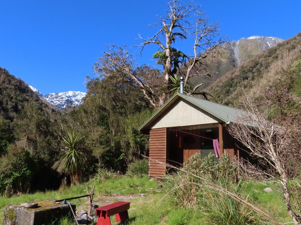
Crawford Junction HUT

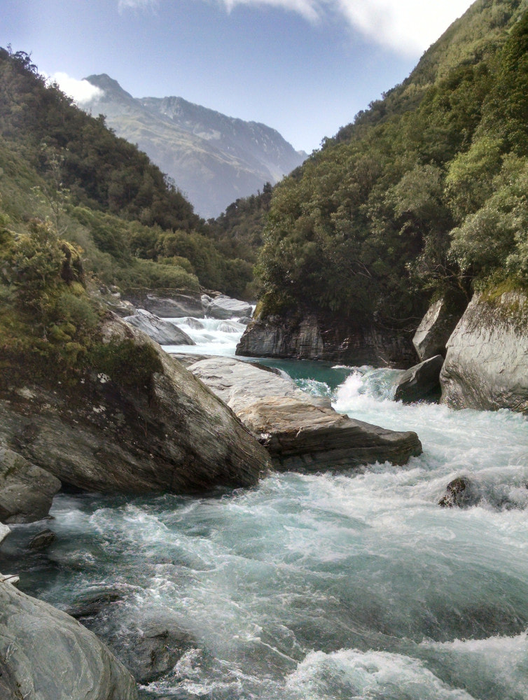
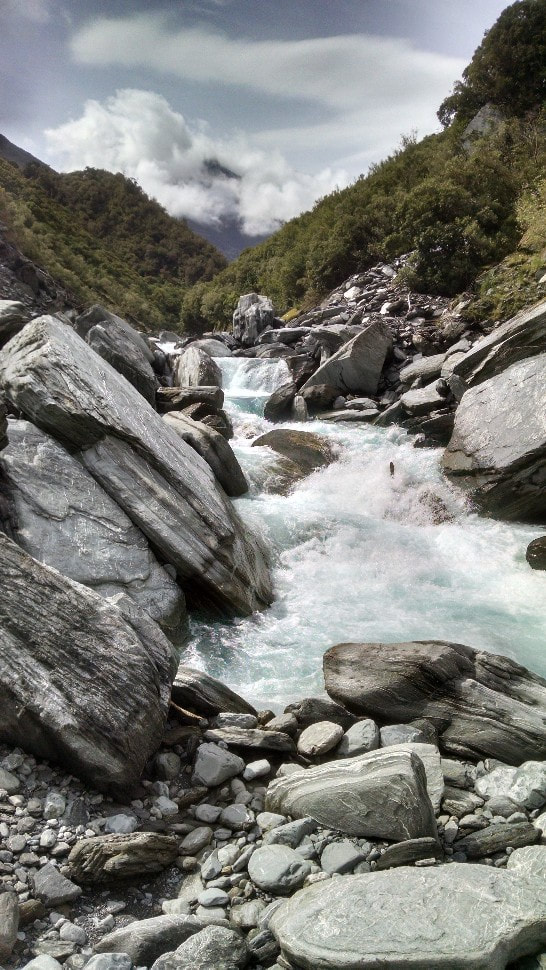 Rough travel - one of the riverbed sections above Twins
Maintenance status
Crawford Junction Hut and its access tracks and routes from the Styx valley via Lathrop Saddle and the Toaroha valley via Zit Saddles are fully maintained by the Department of Conservation. The track in the lower Kokatahi and essential sections of an old NZFS route up the TL of the valley from Boo Boo Hut are being maintained by various members of the outdoor community. The latest to take an interest is Daniel Gillies of Christchurch
Location
Kokatahi catchment. Map BV19. Grid Ref: E1455989/ N5242063 (BV19 560 421). Altitude 433m. Crawford Junction Hut is located at the junction of the Crawford and Kokatahi Rivers. It is on the Lathrop Saddle - Zit Saddle circuit, a reasonably popular wilderness route of moderate difficulty. The forest around the hut is predominantly rata/ kamahi and hardwood. There is a fairly large open river flat downriver from the Junction, and the hut site is open and sunny. The Lathrop - Zit circuit has become more popular post-covid with over 30 parties passing through Crawford Junction in 2023. Getting to the Hut from either the Styx or Toaroha road end takes a good two to three days. The valley route which requires higher levels of skill and fitness can be done in 7-9 hours by an experienced party.
Access
For the first time in many years, it is quicker to get to Crawford Junction up the main Kokatahi valley than it use using the DOC maintained Lathrop - Zit Saddle circuit. For a long time, this wasn't the case after official maintenance of the track up from Boo Boo Hut ceased in the 1980's. In the ensuing years the mid valley achieved considerable notoriety for its roughness, with accounts aplenty of epic journeys in the hutbooks. Permolat volunteers reopened the track from Boo Boo to the Twins bridge in 2005, and some of the bluff detours on the TR from there to the Junction were cut and marked in 2017. The bridge was badly damaged by a slip and removed by DOC in July 2021, so we went back in and opened up an old NZFS route on the TL. This hadn't been maintained since the early 1970's and had pretty much vanished back into the bush. A route was cruise-taped as close as possible to the old trackline which still had the odd bit of original permolat in places. In October 2021 a Permolat team went in and recut and marked the bush sections of the route. The re-established track is rough and unformed, but well-marked. It crosses some actively unstable patches and has a few sections of boulder travel. Three short bush detours that allow passage from the Crawford confluence up to the Kokatahi cableway were added a month later. As mentioned above, a DOC track cutting team kindly did a chainsaw run on their way out from the upper valley in June 2023.
From Boo Boo the track sidles along the bush faces for a half hour or so to some dry rocks, the larger and more weatherproof of which is 20m uphill from the track. A plastic water barrel has been placed there to provide a bit of water. The track drops from here in a series of steps into Pinnacle Creek, then up and over a narrow rib into Alice Creek. It crosses another rib into Meharry Creek and up onto the terrace and clearing where Twins Hut used to be. The re-established route starts here dropping steeply off the terrace and angling down a steep overgrowing slip into the riverbed. There follows an actively unstable section with big boulders and short bush detours to an unmarked side-creek where the track enters the bush, climbs, then sidles across the bush faces above the river. The track drops back to the riverbed at the unnamed creek 500m downriver from Blue Duck Creek. A mix of track and boulder travel takes you to the Blue Duck which is crossed to another short section of track that takes you to where the Kokatahi cuts into a shingle bluff. A short wade is required to get you around the bluff and back onto open riverbed.
The Kokatahi can usually forded here, and a direct line taken up the flats on the TR to the Crawford River which currently runs in three normally easy forded braids opposite the Hut. If a ford above the Blue Duck is not possible, continue up the riverbed on the TL (with one small, tracked bluff detour) to where the Kokatahi splits into two braids just above the Crawford confluence. If a ford is possible here, continue another 20 minutes upriver to the cableway. In addition to the Kokatahi, both Alice and Blue Duck creeks could be dangerous or uncrossable if running high. Allow 4-5 hours for the journey from Boo Boo to Crawford Junction and be prepared for some quintessentially rough West Coast bush and river travel.
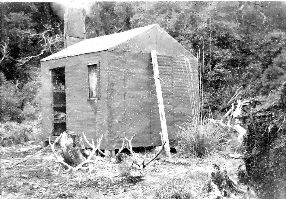 Crawford Junction 1957
From Crawford Junction the Top Crawford Hut route follows the riverbed for around 15 minutes, then enters the bush and passes through a nice patch of rata forest before hitting Farquharson Creek. This is a big stream that is impassable when it's running high. There used to be a swingbridge over it way back, but it got washed away. The track undulates along the river for around one km, then does a steepish climb before levelling and sidling at quite a high level above the Crawford River. It passes through montane and subalpine forest on its gradual ascent to the top basin. The last 15-20 minutes before the basin is river travel. The track was recut by DOC in June 2023 and is in good condition currently. Allow 3-4 hours for the trip up.
The track from Crawford Junction Hut to Top Kokatahi Hut follows the TR of the upper Kokatahi until just past the first side-creek, where a cableway provides access to the TL. The track follows the TL for around four kilometres to a swingbridge which takes you back to the TR. From here to the Hut travel is rough, however the tracked bits are good going. Just below the Hut the River has cut against the bank in a couple of places and a couple of short scrub bashes are required. The track was recut by DOC in 2023. Allow 5 plus hours to get to Top Kokatahi Hut from Crawford Junction currently.
Type
The original Crawford Junction Hut was probably built by the Department of Internal Affairs in the early/ mid 1950’s and extended at some point when NZFS took over the valley. Bill Johnson was a culler at the time and did a lot of early hut building. He first used the Hut in April 1960 and said it was already extended by then, badly in need of care, and not a lot of fun to sleep in with rats and possums rustling around at night. It was also reputed by some to have a ghost in residence. Lands and Survey built the new Hut next to the old one which served as a drying shed for possumers until removed by DOC in the early 2000's. The current Hut is a wooden cladded structure, the inside walls and floor timber-lined, and has a spacious veranda at the front. There are six bunks with mattresses, and a wood burner, and the Hut is cozy when the burner is cranked up. There is a roof-fed water tank and a loo that has an impressive barrier fence to stop people falling three metres down onto the riverbed. The only downside to the Hut's design is that rats are easily able to get into the ceiling cavity. Luckily, they seem to confine themselves to this space, rustle about a bit in the early evening, then quieten down for the night.
Condition
Crawford Junction Hut is in good condition currently. In 2018 DOC Hokitika did a good round of maintenance and site clearance. The rats had made a bit of a mess in the roof cavity, eating out a lot of the building paper and insulation, as well as a small section of the ceiling. The roof iron had to be removed to clean it up. The old wood burner was removed and a new one installed and shifted into the corner of the Hut. This may have created a new problem as bits of chewed building paper or other rat detritus may be coming into contact with the flue up in the roof space and creating a fire risk. Subsequent reports have highlighted the rat problem which appears to be ongoing.
Routes
There are a couple of old tops tracks in the vicinity of Crawford Junction, neither of which are likely to be of much use anymore. One directly behind the Hut used to go up onto the Main Divide. It's pretty much unfollowable in most places now, but if you were silly enough to go up that way you may find the odd permolat marker. There is a nice tarn and campsite on the NW flank of Mt. Fitzgerald at 1420m, and from here a good high sidle at just above the 1500m contour will get you around to Clarkes Pass.
The easiest approach to Clarkes Pass is by way of the Top Kokatahi track as far as Clarkes Creek. Ford the Kokatahi here and head up the ridge on the TL of Clarkes Creek. The bush isn't too bad going and at some point above the 800m contour it is possible to sidle into the Creek's upper basin. The sidle is reportedly less fun these days. Don't go directly up the Creek from the Kokatahi River unless you have some means of scaling large waterfalls. Once in the basin it is generally easy going, as are the approaches to the Pass. The Griffiths Stream side is a steep scree in late summer and autumn, and snow covered and possibly icy at other times. Ice axes and crampons need to be carried if crossing over in the colder months.
There once was an NZFS tops track up onto Whitehorn Spur starting somewhere around E1456394/ N5242400 (BV19 564 424). I wasn't able to find any semblance of it on a climb of Tyndall Knob in 2021, neither going up nor down. It's not a well-defined spur and the bush and scrub travel is nothing to recommend. There is a dry gut in the bush roughly opposite the hut which if you are fortunate enough to locate, will get you there a bit easier. The same goes if you are able to pick up a decent deer trail. Once on the open tops it is great travel.
Pinnacle Biv can be accessed directly from Crawford Junction via Blue Duck Creek, although the route is reasonably gnarly in the middle section. Head downvalley, ford the Kokatahi, then follow the Blue Duck up until just before the first gorge. Exit the Creek here up a slip on the TL and when sufficiently high it you'll need to do a scrub bash/ sidle back into the Creek. This is followed again to a second set of falls in the upper basin which can be negotiated fairly easily. From here Point 1618m can be accessed up the tussock slopes and crest of the Range followed from here. Adventure Biv could also be accessed in this fashion.
Repairs Needed
Not many. Keep an eye on the flue space in the roof when lighting the fire. It may actually be necessary to do something if rat nesting material is coming into contact with the flue up there. Installing a self-setting trap wouldn't be a bad idea. The door doesn't always close properly even when it sounds like it has. A small bolt would add a little extra certainty. The current bait station still has a bit of bait, but this probably won't last long going by the hut book entries.
Provisions on site
An axe, a bucket, a bow saw, a broom, a hearth brush and shovel, a 10-litre stock pot, a small billy, a small pot, a large shovel. Under the Hut there are bits of a cableway tower, one long section of plastic downpipe, two rolls of no. 8 wire, a waratah, a sheet of corrugated iron, a roll of chicken wire, one large 8x2 with treads for roof painting, a 10-litre pail of brown exterior paint, and a few odds and sods of timber.
