Boo Boo Hut

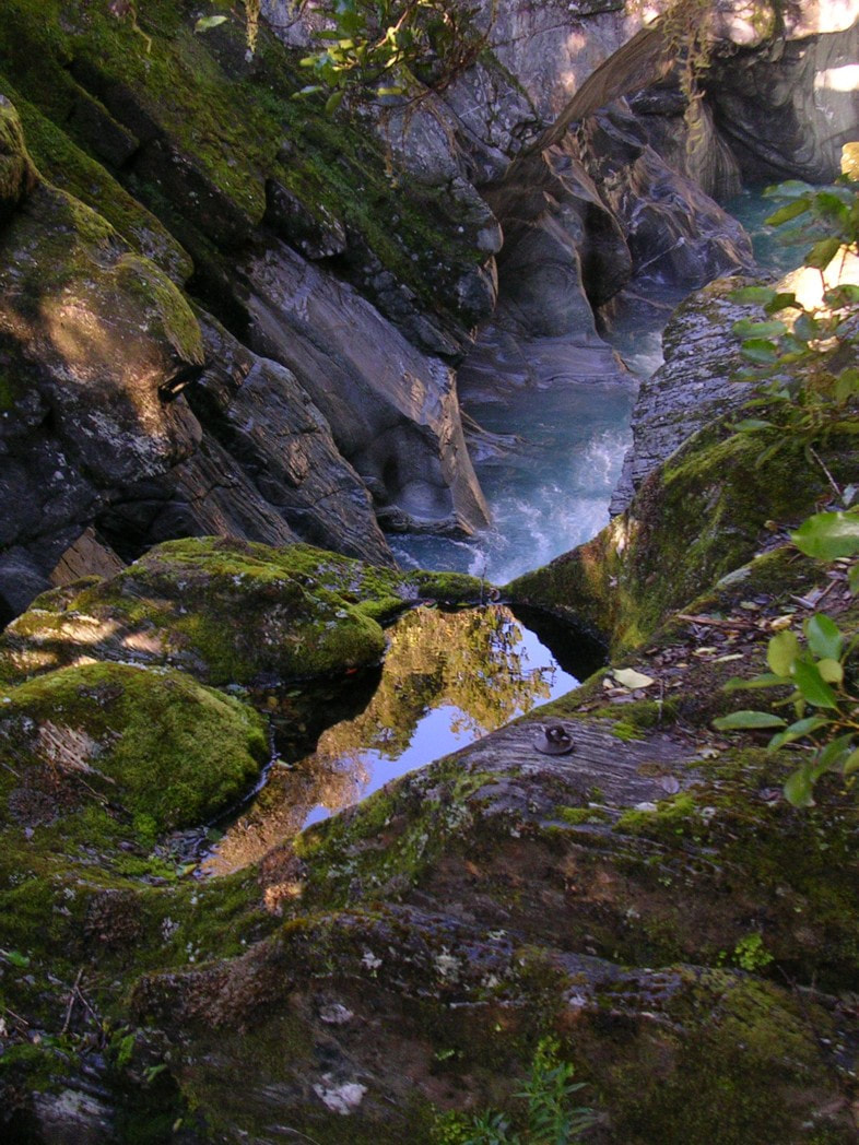

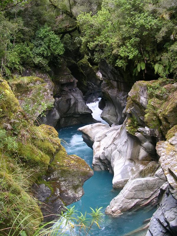 Whakarira Gorge
Maintenance status
Boo Boo Hut was designated as a minimal maintenance structure by the Department of Conservation in 2004. Happily, the work carried out by them since then has been more than minimal. It included taking out the original open fire and installing an efficient woodburner in 2012, and in May '24 a significant overhaul. The Boo Boo and Pinnacle Biv tracks and the tracked and sections on the mid valley route to Crawford Junction Hut have been maintained by volunteers for a considerable time now. The latest to take an interest in maintaining the routes is Daniel Gillies of Christchurch. In June '23 a DOC track cutting crew were kind enough to do a chainsaw run on their way out from the upper valley where they were doing some work.
Location
Kokatahi catchment. Map BV19. GPS Ref: E1452973/ N5245567 (BV19 530 456). Altitude 615m. Boo Boo Hut is located in the rata belt on the TL bush faces of the Kokatahi valley. It was rumoured that it got its name from a cocked-up food drop at a deer cullers camp there in the 1950s, however the NZMS13 map from 1919 has the creek next to the Hut named as Booboo Creek. Boo Boo Hut has historically been a low-use facility with visits becoming even less frequent between 1990 and the early 2000s due to deteriorating track conditions. Things picked up after volunteers started working on the lower and mid valley routes in 2005, and it the hut was profiled on this website. Boo Boo currently gets around 30 visits a year, a fair proportion of whom are doing a traverse of the Toaroha Range from Pinnacle Biv. Smaller numbers are braving the once notorious mid-valley route up to Crawford Junction. Boo Boo's sunny aspect and woodburner make it a great all-season spot for an overnight trip as well.
Access
Access to the Boo Boo route is up a farm trail that turns off Middlebranch Road at a car park there with DOC signage just before the Kokatahi Bridge. The farm track peters out near an old cableway at a bend in the Kokatahi River and the river is followed for 15 minutes to a large grassy flat further upstream which is freehold land to the first side-creek. A track enters the bush at the top of the flat and follows the TR of the Kokatahi to the Whakarira Gorge bridge. The view of the Gorge from it is stunning and worth a visit in its own right. Flood debris is occasionally found jammed under the bridge and gives an indication of how high the river can get after heavy rain. After crossing to the TL, the track climbs a bit, then drops back to the riverbed at Adamson Creek. There is a 200m stretch of river travel before the track re-enters the bush and climb/ sidles up around the bush faces to the Hut. A fit party should be able to get from the roadend to Boo Boo in 4 to 5 hours. The track is in pretty good condition currently and was tidied up by Daniel and some Canterbury Tramping Club mates in July.
A clearing at the Pinnacle Biv turnoff five minutes before the Hut provides helicopter access.
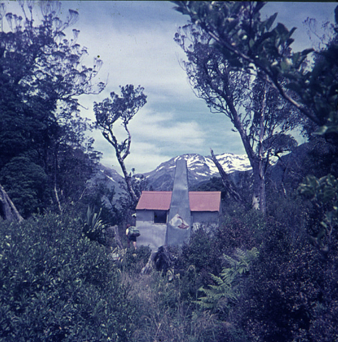 Boo Boo Hut 1974
Type
Boo Boo Hut was in the first batch of New Zealand Forest Service 4-bunk S81 designs built in 1959 and had an open fire and perspex windows. Lands and Survey added a woodshed and covered porch and lined the Hut lined in the early 1980s when they were looking after the valley. The fireplace was removed by DOC and replaced with a Little Cracker wood burner in 2012. There is a toilet and water is from the creek next to the Hut.
Condition
Boo Boo had some of its joists bearers and piles replaced at some point, most likely during Lands and Survey's tenure (pre-1987). In 2004 DOC repainted the Hut and cleared a bit of the scrub around it. In 2012 more exterior painting was done, the clearlite on the roof replaced, and the woodburner installed. In 2023 DOC replaced some of the piles and the lead head nails on the roof with tech screws. The helicopter pad was cleared and upgraded. The rest of the piling and sub floor work was done in May '24. The window on the north wall was replaced by a double glazed one. The old leaky porch was replaced with a new structure, and the roof ridging and flashings replaced. The toilet was re-sited and rotated. Some of the regenerating bush on the NE side of the hut site was cut back. The door handles on the wood burner are angled and people tend to jam them by forcing them the wrong way.
Routes
Official maintenance of the route from Boo Boo to Crawford Junction Hut ceased sometime in the 1980's. In the ensuing years this part of the valley achieved considerable notoriety for its roughness, with hut book accounts aplenty of epic trips. Permolat volunteers reopened the track from Boo Boo to the Twins swingbridge in 2005, and some of the bluff detours on the TR from the 3-wire that replaced the bridge to the Junction were cut and marked in 2017. The 3-wire was badly damaged by a slip and removed by DOC in July 2021, so we went back in and opened up an old NZFS route on the TL. This hadn't been maintained since the early 1970s and had pretty much vanished back into the bush. A route was cruise-taped as close as possible to the old trackline which still had the very odd bit of original permolat here and there. In October 2021 a Permolat team went in and recut and marked the bush sections of the route. The re-established track is rough and unformed, but well-marked. It crosses some actively unstable patches and has a few sections of boulder travel. Three short bush detours that allow passage from the Crawford confluence up to the Kokatahi cableway were added a month later. A DOC track cutting team kindly did a chainsaw run on their way out from some work in the upper valley in June 2023.
From Boo Boo the track sidles along the bush faces for a half hour or so to some dry rocks, the larger and more weatherproof of which is 20m uphill from the track. A plastic water barrel has been placed there to provide a bit of water. The track drops from here in a series of steps into Pinnacle Creek, then up and over a narrow rib into Alice Creek. It crosses another rib into Meharry Creek and up onto the terrace and clearing where Twins Hut used to be. The re-established route starts here dropping steeply off the terrace and angling down a steep overgrowing slip into the riverbed. There follows an actively unstable section with big boulders and short bush detours to an unmarked side-creek where the track enters the bush, climbs, then sidles across the bush faces above the river. The track drops back to the riverbed at the unnamed creek 500m downriver from Blue Duck Creek. A mix of track and boulder travel takes you to the Blue Duck which is crossed to another short section of track that takes you to where the Kokatahi cuts into a shingle bluff. A short wade is required to get you around the bluff and back onto open riverbed.
The Kokatahi can usually forded here, and a direct line taken up the flats on the TR to the Crawford River which currently runs in three normally easy forded braids opposite the Hut. If a ford above the Blue Duck is not possible, continue up the riverbed on the TL (with one small, tracked bluff detour) to where the Kokatahi splits into two braids just above the Crawford confluence. If a ford is possible here, continue another 20 minutes upriver to the cableway. In addition to the Kokatahi, both Alice and Blue Duck creeks could be dangerous or uncrossable if running high. Allow 4-5 hours for the journey from Boo Boo to Crawford Junction and be prepared for some quintessentially rough West Coast bush and river travel.
The Pinnacle Biv track starts at the top of the helipad, five minutes downvalley from Boo Boo Hut. It was re-cut and marked by volunteers in March and May 2020. The trackline follows the TL of a small creek initially, then heads straight up the montane faces eventually connecting with a broad spur at the tussock line. Poles and cruise-tape lead from here through the tussock and a couple of bands of scrub towards point 1085m. The route sidles east just below point 1085m and crosses a scrubby gully onto a rib with exposed bare rock. The route continues up this rib, over point 1085m, drops into a dip then climbs the last section through another band of alpine scrub towards Crinkletop. The track is still in reasonably good shape although flax is starting to crowd it in some of its upper portions. Allow around three hours from Boo Boo to Pinnacle Biv currently, or 8-9 from the roadend.
When dropping from Pinnacle Biv down to Boo Boo Hut make sure you don't continue down the exposed rock rib East of point 1085m. The trail drops off the rib around E1452037/ N5244963 (BV19 520 450) and sidles North across a scrubby face to another open area. More than one party continued straight down the rib into the Kokatahi. The top entrance of the track proper is also a bit vague currently. It's at GPS E1452097/ N5245430.
Repairs needed.
None currently.
Provisions on site
A coal bucket, two brooms, a hearth brush, a fry pan, a medium-sized pot, a billy, a plastic bucket, a bow saw, a shovel, an axe, and an ash bucket. There is a bait station in the vestibule.
