Kiwi Hut
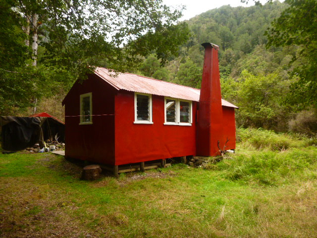 Kiwi Hut prior to rebuild
Location
Taramakau catchment. Grid Ref: E1495191/ N5265340 (BU21 952 653). Map BU21. Altitude 340m. Kiwi Hut is located on a patch of freehold land on a bush terrace between Jacksons and Michael Creek on the TR of the Taramakau valley. There is a large grass clearing just below the Hut, with a narrow band of forest between it and the riverbed. There is quite prolific bird life in the area with populations of kiwi and kaka most notable along with other native birds. Department of Conservation has an active predator control programme running in the valley.
Maintenance Status
Kiwi Hut was designated for removal by DOC in 2004, but they later backtracked following strong opposition from the local back-country community. It was picked up as a maintain-by-community project by Graeme Jackson of Hokitika whose family have a longstanding connection with the valley. At the time Kiwi was being used mostly by local hunters and trampers but that changed significantly with the advent of the Te Araroa Trail which runs down the Taramakau valley. Since the Trail's inception visits to Kiwi hut have risen exponentially and put pressure on the hut which had become grubby and run-down due to the overuse. Graeme had obtained the necessary consents and Back Country Trust funding to carry out repairs and replace the ageing open fireplace with a woodburner when DOC and BCT decided to step in. A complete renovation of the Hut took place in the summer of 2023/24 funded by a generous bequest from the Henwood family in memory of their late mother who was a keen tramper.
In fine weather Kiwi Hut is a relatively easy three-hour walk from SH 73 and is an ideal introduction for kids and the less experienced to the backcountry. It is also accessible by high stud 4WD vehicles which leaves it vulnerable to the hoon element. In addition, many of the Te Araroa walkers seem to have no understanding of basic hygiene or hut etiquette. More than one regular visitor to the hut has noted a tendency they have of leaving the hut grubby and the wood supply depleted and not replaced.
Access
Access to Kiwi Hut starts on Aickens Corner on State Highway 73. Fords of the Otira and Taramakau are necessary and also the Otehake if folk choose to stick to the TL of the valley. All these rivers are hazardous or impossible to cross when rain causes them to rise above normal flows, so a good weather window is essential for trips into the valley. From the car park follow the markers along the paddock fenceline through a gate to the Otira River. The best crossing currently is a couple of hundred metres upstream from here at a point where the river braids. Cross and head due east across a gorse island to the track start which is marked by a large orange triangle. If the Otira is unfordable there is a flood track down its TR from the Deception Footbridge. This adds a good hour to the trip and if the Otira is running high, the Taramakau and Otehake will most likely be as well. in which case you might want to pause and reconsider taking the journey.
A track starts on the TR of the Otira and cuts through a patch of forest, then follows the bush fringes of the Taramakau to a 4WD trail. This is followed past the Lake Kaurapataka turnoff (100m before Pfeifer Creek) and ends abruptly at the river's edge. The Taramakau can be forded diagonally here (there are normally a number of braids that make fording easier) and the TR followed. the official route, probably the quicker of the two, stays on the TL and requires a 15-minute bush bash where the river has cut in on a bend around 2km above Pfeifer Creek. Further up the Otehake needs to be crossed, the best ford being upstream a bit where it widens and flattens somewhat. Just upstream of the Otehake a series of marker poles can be followed in a diagonal line across the braids of the Taramakau to the TR Bank. Continue upriver from here to a signed turnoff around 600m upriver from Jacksons Creek. A track leads from here through a narrow band of beech forest and across a big grassy clearing to the low terrace on which the Hut is sited. Allow around three hours to reach Kiwi Hut from the highway.
Type
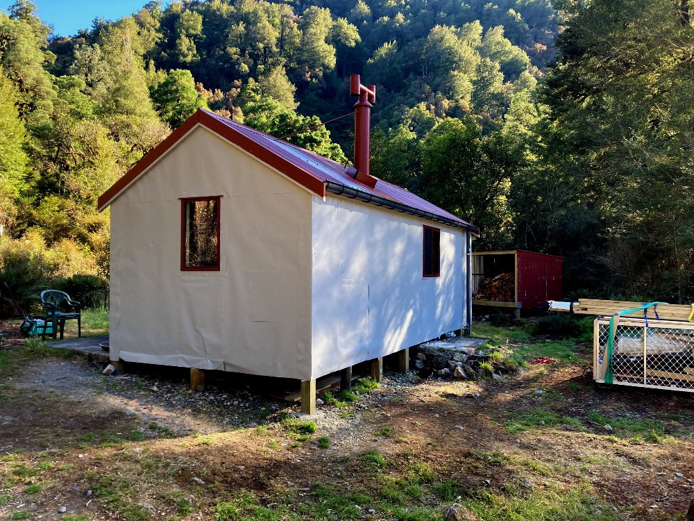
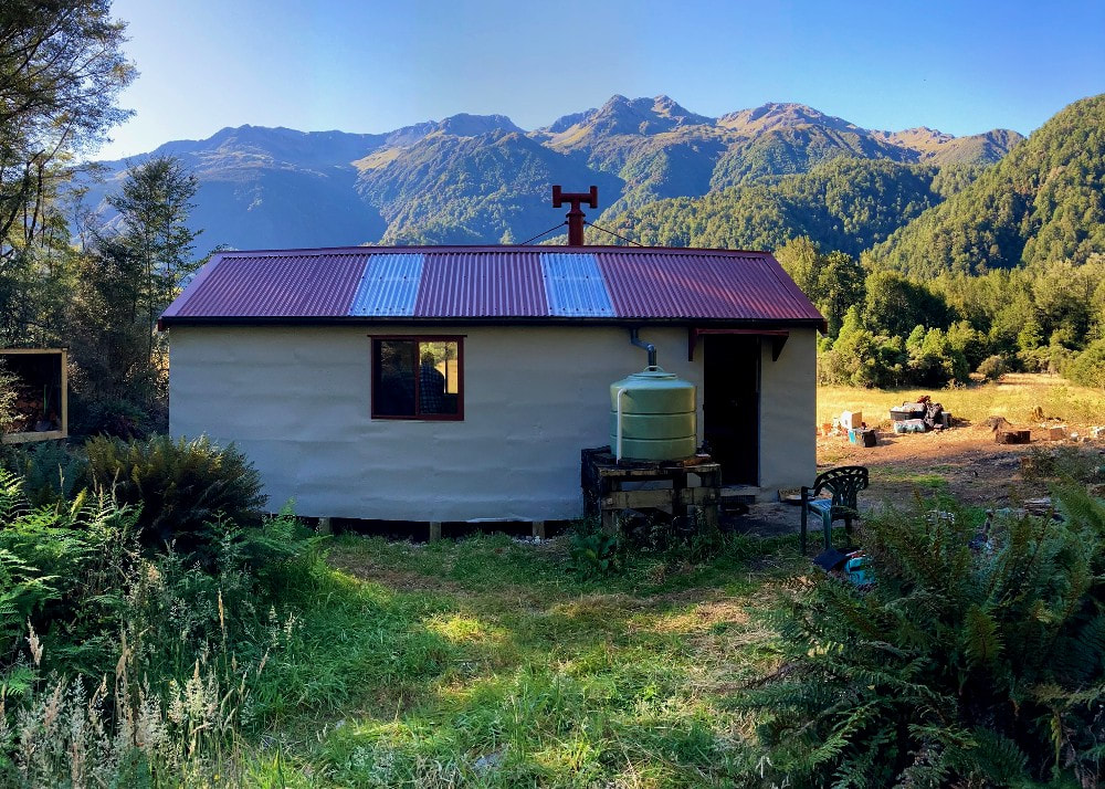
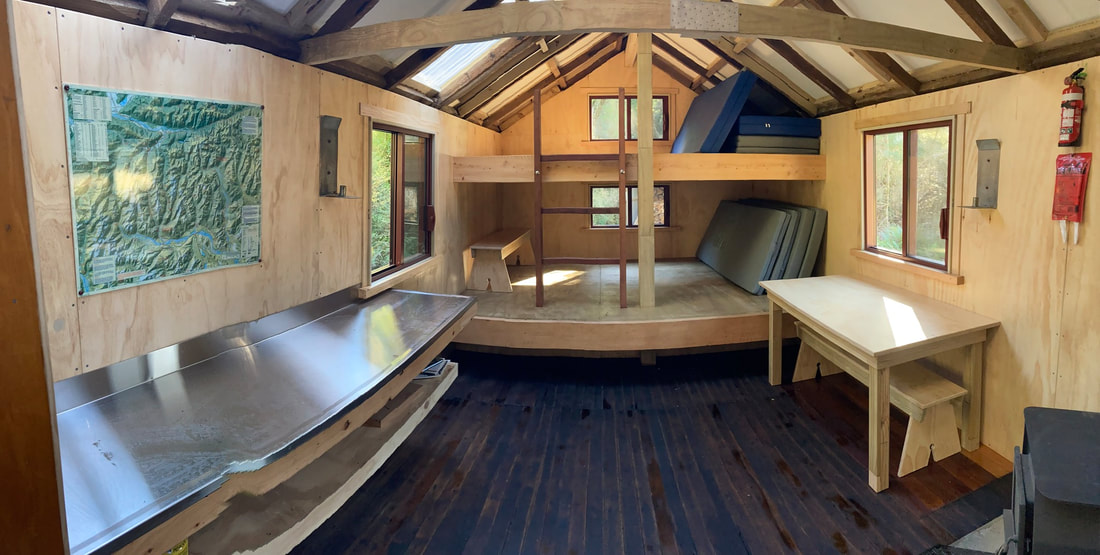
Kiwi Hut was a New Zealand Forest Service S70 6-bunk design with open fire that had an added alcove area at one end. It was built in 1967 with treated timber from a Greymouth mill. Over the years Graeme repainted the hut and replaced some piles and rotten window frames. The 2023/ 24 BCT team was assisted by DOC workers who felled a lot of the regenerating beech that was encroaching the hut site making things damp, shady and at risk of windthrow. The new modified version keeps the old shell, frame and external cladding but has been gutted and relined, had the roof replaced, been re-piled, had the chimney removed and a wood burner installed, had the original bunks replaced with two bench bunks each sleeping four persons, had two more bunks added in the alcove, and single pane windows installed in place of the original louvre ones, There is a roof-fed water tank, a new woodshed, and a long drop toilet.
Taramakau catchment. Grid Ref: E1495191/ N5265340 (BU21 952 653). Map BU21. Altitude 340m. Kiwi Hut is located on a patch of freehold land on a bush terrace between Jacksons and Michael Creek on the TR of the Taramakau valley. There is a large grass clearing just below the Hut, with a narrow band of forest between it and the riverbed. There is quite prolific bird life in the area with populations of kiwi and kaka most notable along with other native birds. Department of Conservation has an active predator control programme running in the valley.
Maintenance Status
Kiwi Hut was designated for removal by DOC in 2004, but they later backtracked following strong opposition from the local back-country community. It was picked up as a maintain-by-community project by Graeme Jackson of Hokitika whose family have a longstanding connection with the valley. At the time Kiwi was being used mostly by local hunters and trampers but that changed significantly with the advent of the Te Araroa Trail which runs down the Taramakau valley. Since the Trail's inception visits to Kiwi hut have risen exponentially and put pressure on the hut which had become grubby and run-down due to the overuse. Graeme had obtained the necessary consents and Back Country Trust funding to carry out repairs and replace the ageing open fireplace with a woodburner when DOC and BCT decided to step in. A complete renovation of the Hut took place in the summer of 2023/24 funded by a generous bequest from the Henwood family in memory of their late mother who was a keen tramper.
In fine weather Kiwi Hut is a relatively easy three-hour walk from SH 73 and is an ideal introduction for kids and the less experienced to the backcountry. It is also accessible by high stud 4WD vehicles which leaves it vulnerable to the hoon element. In addition, many of the Te Araroa walkers seem to have no understanding of basic hygiene or hut etiquette. More than one regular visitor to the hut has noted a tendency they have of leaving the hut grubby and the wood supply depleted and not replaced.
Access
Access to Kiwi Hut starts on Aickens Corner on State Highway 73. Fords of the Otira and Taramakau are necessary and also the Otehake if folk choose to stick to the TL of the valley. All these rivers are hazardous or impossible to cross when rain causes them to rise above normal flows, so a good weather window is essential for trips into the valley. From the car park follow the markers along the paddock fenceline through a gate to the Otira River. The best crossing currently is a couple of hundred metres upstream from here at a point where the river braids. Cross and head due east across a gorse island to the track start which is marked by a large orange triangle. If the Otira is unfordable there is a flood track down its TR from the Deception Footbridge. This adds a good hour to the trip and if the Otira is running high, the Taramakau and Otehake will most likely be as well. in which case you might want to pause and reconsider taking the journey.
A track starts on the TR of the Otira and cuts through a patch of forest, then follows the bush fringes of the Taramakau to a 4WD trail. This is followed past the Lake Kaurapataka turnoff (100m before Pfeifer Creek) and ends abruptly at the river's edge. The Taramakau can be forded diagonally here (there are normally a number of braids that make fording easier) and the TR followed. the official route, probably the quicker of the two, stays on the TL and requires a 15-minute bush bash where the river has cut in on a bend around 2km above Pfeifer Creek. Further up the Otehake needs to be crossed, the best ford being upstream a bit where it widens and flattens somewhat. Just upstream of the Otehake a series of marker poles can be followed in a diagonal line across the braids of the Taramakau to the TR Bank. Continue upriver from here to a signed turnoff around 600m upriver from Jacksons Creek. A track leads from here through a narrow band of beech forest and across a big grassy clearing to the low terrace on which the Hut is sited. Allow around three hours to reach Kiwi Hut from the highway.
Type
Kiwi Hut was a New Zealand Forest Service S70 6-bunk design with open fire that had an added alcove area at one end. It was built in 1967 with treated timber from a Greymouth mill. Over the years Graeme repainted the hut and replaced some piles and rotten window frames. The 2023/ 24 BCT team was assisted by DOC workers who felled a lot of the regenerating beech that was encroaching the hut site making things damp, shady and at risk of windthrow. The new modified version keeps the old shell, frame and external cladding but has been gutted and relined, had the roof replaced, been re-piled, had the chimney removed and a wood burner installed, had the original bunks replaced with two bench bunks each sleeping four persons, had two more bunks added in the alcove, and single pane windows installed in place of the original louvre ones, There is a roof-fed water tank, a new woodshed, and a long drop toilet.
Condition
The hut should be in mint condition now for some time to come if it isn't wrecked by overuse. There have already been reports of it being left dirty and the firewood supply not being replaced. There was a recent report of a rat and mouse infestation and some poison and bait stations have been provided to counter this. There are also some stoat traps, so if you are in there, please check them and clean them out
Routes
It is a couple of hours of mostly river travel on the TR from Kiwi Hut up to Locke Stream Hut. It is possible to ford to the TL in places to get a better line but doing this probably won't make a huge difference to travel times. A ford to the TL is necessary at some point however as Locke Stream and the last section of track is on the TL.
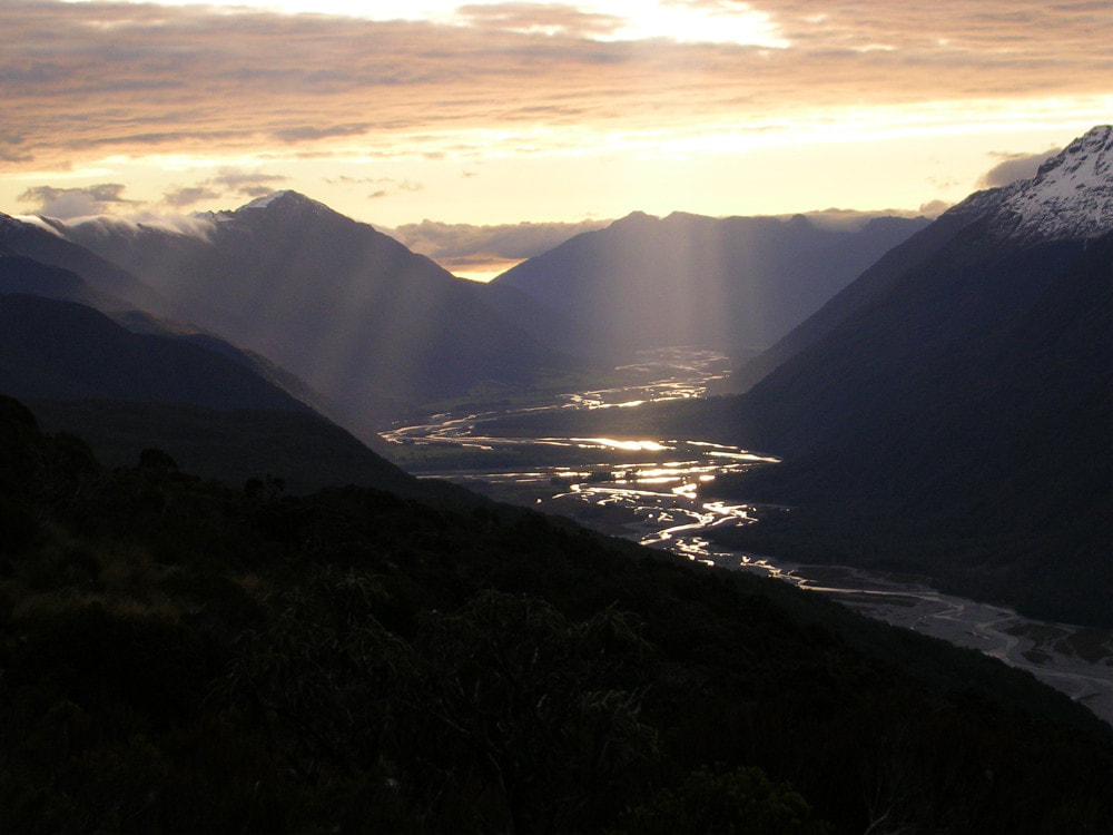 Looking down the Taramakau from the Townsend tops
The track to Townsend Hut starts around 20 minutes upriver from Kiwi Hut on the TL of the valley. Head along the grass flats on the TR initially, then cross to the TL just above where Michael Creek comes in. The route commences at a large orange triangle on the TL fan of the unnamed creek 400m upriver from Michael Creek at GPS REF: E1499016/ N5265136. Markers lead up through the rocks, regrowth and dead spars to the creek bed which is followed up past a small fork on the TR. At around 520m (GPS Ref: E1499387/ N5264622) the track proper exits and climbs steeply up the bush faces onto a narrow ridge. It follows this up through the sub-alpine zone to the lip of the scarp on which the Hut is located. The last stretch along the scarp is through scrub and open tussock with small tarns. The tracked sections up to the Hut are in pretty good condition currently. John Roper-Lindsay and Dan Murphy did some trimming and marking on the lower bits in July 2020, and I worked on the final approaches to the Hut in November. Allow 2-2.5 hours for the trip from Kiwi Hut to Townsend Hut, or 4-6 hours from the roadend.
Koropuku Hut can be accessed from Kiwi Hut via the lower Otehake River. Ford to the Taramakau and head down the TL bank to the Otehake confluence. Boulderhop up the Otehake for around an hour, crossing and recrossing where necessary. The start of the track to Koropuku Hut is marked by a large orange triangle opposite where the Lake Kaurapataka track drops down to the river. A swingbridge marked here on older maps was removed by DOC in 2012. The track enters the bush and follows a spur up to the tussock line and is marked with red, or occasionally white permolat. It has been maintained for a number of years now by Frank King and Honora Renwick of Christchurch.
There are great views of Lake Kaurapataka and Mt Alexander and Pfeifer from the Koropuku tops. Cairns and the odd post lead South from the bush edge along a bench and up a series of small terraces to a large tarn at 1495408E/ 5260491N (BV21 954 605), and along to another group of tarns East of Point 1259m. Drop into the Koropuku catchment down a scree just South of the tarns. The scree becomes a steep gut which is skirted on the TR. The gut becomes a creek just past a large rock outcrop with a track exiting and entering the bush on the TL at the top of a series of waterfalls. The track follows a steep gut down before rejoining the creek. This section is starting to overgrow and was given a cursory trim in 2012. A second section of track exits the TL further down, dropping to around the 850m contour before levelling and sidling up the TR of the Koropuku. The terrain eventually flattens and the track passes through a clearing named "The Orchard," 150m from the Hut. Allow 6-8 hours from Kiwi Hut to Koropuku Hut.
Access to the tops behind Kiwi Hut is possible up most of the leading spurs which have fairly well-defined deer trails on them. The creeks on the other hand should be avoided without prior knowledge of their topography. In good conditions it should be possible to cross over the Range to Top Crooked and Top Trent Huts. I recut and marked an old NZFS track from the Mt. Dixon tops down to Top Trent in 2011. There are three snow stakes and a few small tarns on the ridge just above the top entrance of the track, which is located around E1504392/ N5271380 (BU21 044 714). A 100-metre band of low alpine scrub between the tussock and the first stake is fairly easy to push through. The track drops down the spur on the TL of an unnamed side-creek, flattening near the bottom and veering West across the terrace to the Hut.
There is mention in the Top Crooked hutbook of an old, unfollowable track up Toms Creek. I started work on an old track up the spur behind Top Crooked Hut in 2018 and managed to cut and mark it to the 1000m contour before losing the line in thick sub-alpine forest around E1492594/ N5270290 (BU21 926 703). I have no idea where it hits the tussock and there is still a good 300 vertical metres of scrub and big boulders to go. A project for someone maybe? There looks to be a good route to the tussock from the Taramakau side up the first side-creek upriver from Toms Creek. A chute and scree coming in on the TL about 500m up this creek takes you straight to the open tops.
Graeme uses a route up the ridge between Jacksons and Michael Creek. There is a lot of windthrow from the flat to the top of first hump, then a mix of deer trails and bush-bashing to Point 1077m. Sidle from here into the head basin of Jacksons Creek, then back up onto the ridge.
Repairs Needed.
Shouldn't be any currently. The rodent situation will need ongoing input. The axe could be replaced with a sturdier wood splitter. A Hut etiquette Sign on the door and something on the TA website might also help raise awareness about what is expected from hut users before they race on to their end goal.
Provisions on Site
One axe.
