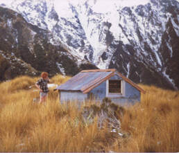
Gerhardt Spur Biv


 Looking down Gerhardt Spur - Photo Jason Sweney
Maintenance Status
Gerhardt Spur Biv is fully maintained by the Department of Conservation. The track, ostensibly DOC maintained, has actually been kept open by volunteers. In 2020 the Permolat group used some bulk funding from the Back Country Trust to recut the main route up the Spur and another access route from the Toaroha side of the Range. Jordan Searle of Hokitika is the latest community person to take an interest in Gerhardt and he and his mates intend doing a bit more trackwork this year.
Location
Hokitika catchment. Map BV19. Grid Ref: E1444715/ N5240380 (BV19 447 404). Altitude 1250m. Gerhardt Biv is located on Gerhardt Spur which runs from the border of the Kowhiterangi Plain to the summit of Jumble Top (1610m) on the Diedrichs Range. The Spur is long and narrow and separates the Diedrichs and Muriel Creek catchments. There are fantastic views from the Biv out over the farmlands to the Tasman Sea. The summit of Jumble Top is an easy 30-minute climb from the Biv in good conditions. Visits to the Biv have increased dramatically from an average 17 per anum pre-2018, to 73 in 2022.
Access
Access to the Gerhard Spur track is via a farm track on the TR of Diedrichs Creek starting at the bridge on the Hokitika Gorge road. Please don't park your vehicles in front of the farm gate. There is a stile to get around the gate and markers and poles need to be followed from here through grazing concession land to Muriel Creek. Continue up the TR of Diedrichs Creek for around one kilometre to where it cuts in against a shingle bluff. You'll need to get wet feet here to get to the track start just above the bluff (E1439727/ N5240703) (BV18 397 407) The track climbs steeply initially, then eases a bit before another very steep section just below Pt 867m. The Spur then flattens, levels, dropping a little for the next 1.5km. The gradient steepens again ascending through a band of pink pine onto a bench with open tussock patches and tarns at 960m. Another steep section follows to a bench at 1120m where odd bits of debris from the original Gerhardt Biv can be found. A final steep section follows up through a last band of alpine scrub onto a flat area of ridge where the Biv is located, just off the crest on the Diedrichs Creek side. The track is still in reasonably good shape. There is a bit of seedling regen and windthrow leading up to Pt 867m and regenerating flax and toi toi are starting to crowd the track in places along the flat section. The rest is pretty good. Jordan and his mates are planning a tidy up later this year. Allow 4-6 hours from the Diedrichs Creek Bridge to the Biv.
 Looking out to Lake Kaniere from Jumble Top
Gerhardt Biv can be accessed from Cedar Flat in the Toaroha valley over Squall Peak and Jumble Top. A track from Cedar Flat onto Squall Peak is not officially maintained, but has been kept open by Permolat volunteers. In May and July 2020 Andrew Barker and friends recut and marked the track. It starts 50 meters up the TL of Percy Creek at the bottom of Cedar Flat, climbs steeply through the rata belt to a knoll at 950m, then zigs North across the spur through a grove of leatherwood before resuming its upward trajectory. The top entrance is at 1090m (GPS: E1447197/ N5242071)(BV19 472 421). Waratahs lead through scattered alpine scrub, then open tussock patches, to a rock outcrop at 1200m. There is a large tarn with good campsites on the South side of the ridge at 1240m. From Squall Peak it's a straightforward traverse of Jumble Top to the Biv. An ice axe may be necessary during the colder months on a short, steep pitch on the Gerhardt Spur side of Jumble Top which is occasionally icy. Allow 4-5 hours travel from Cedar Flat to Gerhardt Biv. Times could vary considerably depending on the season and conditions
 David Merrick at the original Biv: Photo Glenn Johnston
Type
Gerhardt Spur Biv was built by New Zealand Forest Service in 1972 to replace an older B55 structure that had blown off its piles lower down the Spur. The new biv was the second in a short run of high-stud B142 designs that were constructed around this time. These models were taller than their predecessors (although still not enough to stand upright in) and had two smallish bunks with mattresses along the side and end walls. The Biv is lined, and of sturdy construction. Back before ubiquitous DOC warning signs the kerosene cooker supplied by the NZFS used to turn the interior rapidly into a sauna, and there was the odd headache from the fumes as I remember. A small tarn nearby supplies water. There is no toilet. There is phone reception on the ridgetop just above the Biv.
Condition
Gerhardt Biv is in great condition currently. It didn't get much maintenance over the years, but its sturdy construction kept it intact and watertight. In 2013 DOC repainted its roof, door and windowsills and in 2024 they replaced the roof, upgraded the tie downs, replaced piles and repainted the Biv. The end bunk was shifted to the side parallel with the other one. The lack of toileting is a problem with the big increase in visitation. DOC have left a shovel there as a measure and Jordan is currently seeking funding to install a low-profile toilet at the site.
Routes
A traverse of the Diedrichs Range from Gerhardt Spur requires the crossing of three small peaks South of Jumble Top. The first, between Jumble Top and point 1612m, has a steep exposed section of blocky, unconsolidated rock on its northern approach, which some find daunting. This can be avoided by dropping down a steep scree on the Diedrichs Creek side of the peak and climbing the TL fork of the scree back onto the Range North of point 1612m. The detour adds around 20 minutes to the traverse.
Jumble Top can be avoided completely by dropping off Gerhard Spur around the 1300m contour into the top fork of Diedrichs Creek (E1445295/ N5240250 (BV19 453 403)). Head up the TL fork to the dip between points 1612m and 1610m. There is water flowing initially, then an easy open scree further up. Point 1610m can be sidled on the Toaroha side. A rock cairn and iron stake on a flat area between points 1780m and 1610m mark the drop-off point into Mullins Basin. The remains of the old Jumble Top Biv can be found on a bench just below here.
Mullins Hut is accessed in a SE direction down a broad face, vertically dissected by a number of deep slots that form creeks lower down. A route has been cut and marked from the 1000m contour through the scrub into the basin. Its top entrance is a waratah at GPS: E1446711/ N5238153 on the TR of the middle of three small creeks marked on the map. Waratahs lead across the face to the top of a trail which was cut and marked in 2022. Allow around four hours to get from Gerhardt Biv to Mullins Hut in good conditions. Ice axes may be needed on the Jumbletop traverse during the colder months.
For those travelling further along the Diedrichs Range, there is an easy sidle of Mt O'Connor on the Mullins side at roughly 1600m which reconnects with the main Range at the saddle before point 1718m. Serpentine Hut in the Hokitika can be accessed from a flat area on the main Range NW of point 1718m. An NZFS track used to drop from here down the ridge immediately behind the Hut. The first section of the drop-off is pretty steep and a bit exposed in places. The top part of the old track can be located on the scrubline, but vanishes completely a short distance further down in dense alpine scrub. A bit more permolat can be found on a knoll down in the montane zone, but the remainder is a rather unpleasant bush-bash down to the river. I did a bit of track clearance up from the bottom of the track in 2017 but have no idea yet where it connects up. An ice axe may be required for the steeper faces on the Hokitika side during the colder months.
An alternative, probably not much better, is to drop down Serpentine Creek from the middle Peak of O'Connor. There are some good campsites in the upper basin however travel further down is rough, with some waterfalls that need sidling around through steep bush. This route has been done at least 3 times in the last 30 years and the least favourable comment is from someone who wrote in the Serpentine hutbook in 2011 that he'd rather have his throat cut than do it again. Allow a long day for both of the above routes.
Frisco Hut in the Hokitika can be accessed by dropping from point 1718m down the ridge on the TR of Darby Creek basin to point 1510m. Drop down the SW spur of 1510m onto the flat tussock bench with tarns below. Waratahs and the odd bit of permolat lead from the SW corner of this bench down through scattered alpine scrub to the top the scrub faces above the Hut. The toilet and part of the roof should be visible from here. Follow the markers off the edge of the bench down the faces into narrow gut that leads through olearia forest to intersect the Darby Creek track 50m East of the Hut. The tracked portion was recut and marked in March 2018. Allow 7-9 hours for the crossing from Gerhardt Biv to Frisco Hut in summer conditions. An ice axe and possibly crampons may be necessary on some of the steeper sections of the traverse during the colder months.
Toaroha Saddle Biv can be accessed from Gerhard Biv along the Diedrichs Range. There are apparently some narrow, exposed sections between point 1718m and Mt Ross that need to be traversed with care. The ridge from Mt Ross down to the Biv is long, gentle and easy. Allow a full day for this crossing.
Top Toaroha Hut can be accessed by dropping off the Range from the dip between points 1524m and 1421m. Descend in a NE direction into the head of the blown-out creek that enters the Toaroha at the bottom of the lake below the Hut. The creek is still actively eroding but provides open access all the way down.
An old NZFS track up onto Mt Robinson was recently reinstated by Permolat volunteers. It starts in Granite Creek at E1438903/ N5240302 and is cut and marked to the tussock at 1230m. From here to Mt Robinson the ridge is rough and undulating with quite a few steep little aretes, and some exposed bits. The notch between Mt Robinson and Pt. 1366m has a steep vertical pitch leading down on which hand holds are minimal, and a rope is recommended. From here it is easy travel along the broad, open ridge leading up to Mt O'Connor. A large tarn at the old Knobby Ridge Biv site near Pt. 1366m provides a good camping spot. This would make for a good three-day tops circuit for the more experienced.
Repairs needed.
Shouldn't be any needed at the moment.
Provisions on site
A slasher, a shovel, a sledgehammer, a hand-brush, a broom with no handle, two billies, an aluminium bucket, an aluminium wash basin, a bench-seat, two paintbrushes, and a coarse file.
