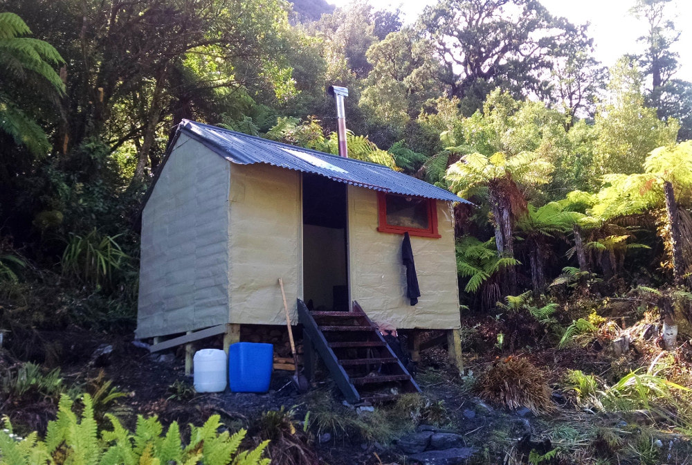
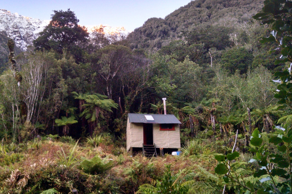
Serpentine Hut
Maintenance Status
Serpentine is a maintain-by-community hut that was originally designated for removal in the Department of Conservation's 2003 high-country review. It was in good condition, but hardly ever visited because the access tracks hadn't been cut since the mid-1970s and had vanished back into the bush. The extremely rough nature of travel both up and downriver from the Hut was an additional deterrent. The place had considerable sentimental value for me, having first visited there in 1973, so when a maintain-by-community project with a local kayaking group fizzled out I signed a contract with DOC. In 2014 we started work opening up parts of the old track around the canyons above the Whitcombe junction, and with Outdoor Recreation Consortium and Permolat funding were able to re-pile and paint the Hut in early 2015. The trackwork to Serpentine and to Frisco, the next hut upvalley, was completed shortly after. This meant that the lower Hokitika routes were open through to the DOC maintained Toaroha-Frew Saddle loop in the upper valley for the first time in almost 40 years.
History
The Maps Past website shows tracks have existed between the roadend and Serpentine since 1899. Sections of benched track below the Hokitika-Whitcombe Junction probably date from the 1880s. Maps Past has a 1919 map showing a track going all the way to Serpentine and beyond. The tracks were put in to assist gold prospectors, and believe it or not, graziers/ drovers. There were a smattering of gold miners working and prospecting in the Hokitika above the Junction at various times from the 1860's to the 1930s. There is one mine shaft very close to the track near the junction and another just above the Kakariki Canyon. Moose were released in the lower Hokitika in the early 1900s but failed to establish. Deer cullers reused some of the old tracks and the New Zealand Forest Service constructed new ones.
Location
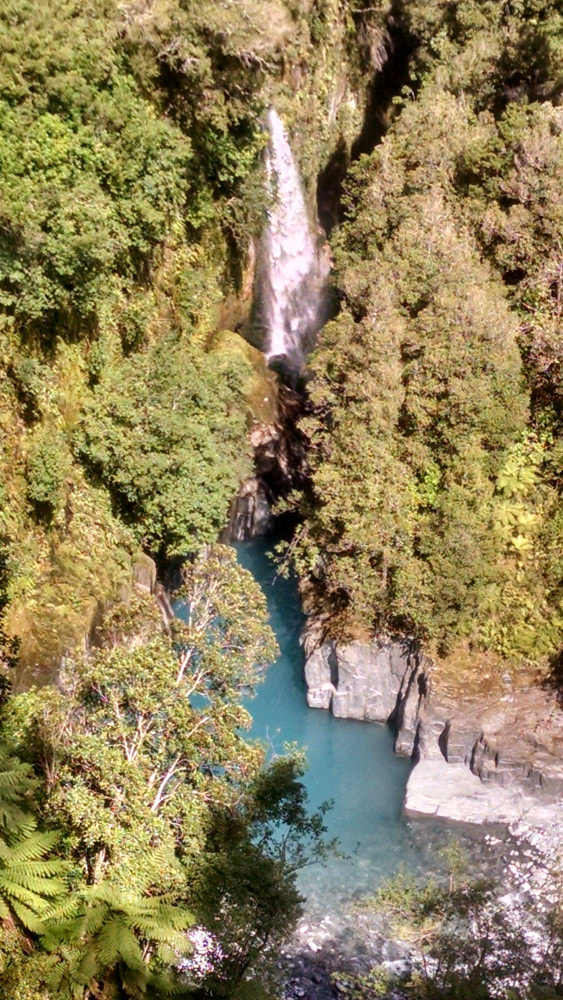
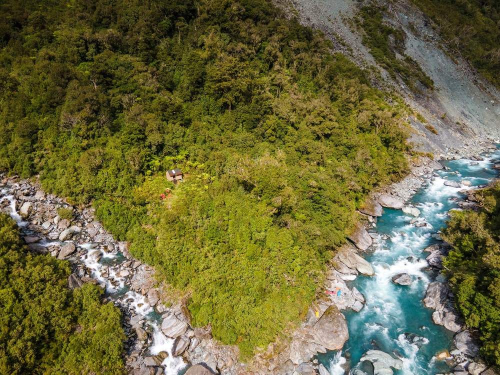
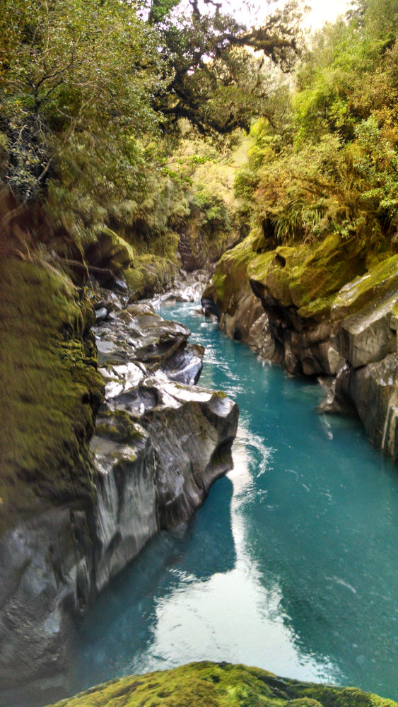
Hokitika catchment. Map BV18. Grid Ref: E1443495/ N5235934 (BV18 435 359). Altitude 300m. Serpentine is located on the TL of a large unnamed side-creek midway up the lower Hokitika valley. There are actually six impressive and visually stunning gorges, only three of which are named on the topo map, between the Hokitika - Whitcombe junction and the Hut. Prior to the opening up of the valley Serpentine had the distinction of being the hut least visited by foot parties on the website. Gaps of 2-3 years between hutbook entries were the norm, with no recorded visits between 1987 and 1993. From then on there were odd drop-ins from kayaking parties who rarely stayed overnight, and very rare foot visits. Serpentine featured briefly in a short film on extreme kayaking called "Flow Hunters." Since the trackwork has been completed there has been a slow stream of visits and 2017 hit an all-time record of 17. There were 13 visits in 2021, seven in '22 and four in '23.
Special Note
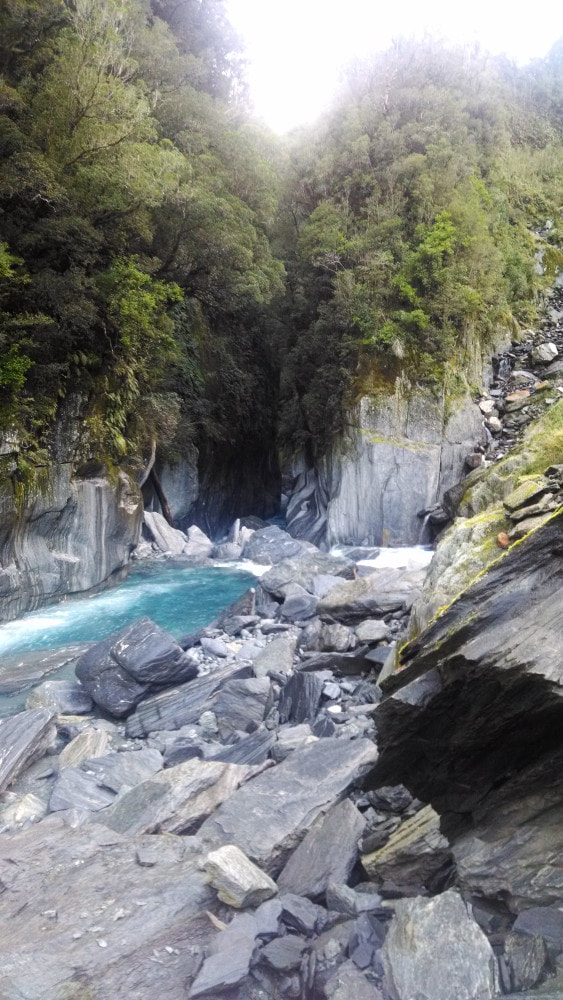
The lower Hokitika is an extremely rugged, gorged valley, and several sections are actively eroding and slipping into the canyons. There are four large unbridged side-creeks that would be uncrossable after heavy rain. Entry points to the tracked sections around the canyons are marked with a combination of permolat, rock cairns, or cruise-tap. The terrain is generally rough, even on the tracked bits, with lots of ups and downs, and there are several sections of riverbed travel. There is a steep, narrow razorback on the descent to the river at the top end of the Kawau Gorge. Parts of it are roped and there are plenty of trees as handholds, but the drop-off on both sides can be vertigo or awe inspiring depending on your genetic makeup. It's a long haul up from the Rapid Creek cableway to Serpentine and very high levels of fitness and experience are essential as prerequisites.
Serpentine is a maintain-by-community hut that was originally designated for removal in the Department of Conservation's 2003 high-country review. It was in good condition, but hardly ever visited because the access tracks hadn't been cut since the mid-1970s and had vanished back into the bush. The extremely rough nature of travel both up and downriver from the Hut was an additional deterrent. The place had considerable sentimental value for me, having first visited there in 1973, so when a maintain-by-community project with a local kayaking group fizzled out I signed a contract with DOC. In 2014 we started work opening up parts of the old track around the canyons above the Whitcombe junction, and with Outdoor Recreation Consortium and Permolat funding were able to re-pile and paint the Hut in early 2015. The trackwork to Serpentine and to Frisco, the next hut upvalley, was completed shortly after. This meant that the lower Hokitika routes were open through to the DOC maintained Toaroha-Frew Saddle loop in the upper valley for the first time in almost 40 years.
History
The Maps Past website shows tracks have existed between the roadend and Serpentine since 1899. Sections of benched track below the Hokitika-Whitcombe Junction probably date from the 1880s. Maps Past has a 1919 map showing a track going all the way to Serpentine and beyond. The tracks were put in to assist gold prospectors, and believe it or not, graziers/ drovers. There were a smattering of gold miners working and prospecting in the Hokitika above the Junction at various times from the 1860's to the 1930s. There is one mine shaft very close to the track near the junction and another just above the Kakariki Canyon. Moose were released in the lower Hokitika in the early 1900s but failed to establish. Deer cullers reused some of the old tracks and the New Zealand Forest Service constructed new ones.
Location
Hokitika catchment. Map BV18. Grid Ref: E1443495/ N5235934 (BV18 435 359). Altitude 300m. Serpentine is located on the TL of a large unnamed side-creek midway up the lower Hokitika valley. There are actually six impressive and visually stunning gorges, only three of which are named on the topo map, between the Hokitika - Whitcombe junction and the Hut. Prior to the opening up of the valley Serpentine had the distinction of being the hut least visited by foot parties on the website. Gaps of 2-3 years between hutbook entries were the norm, with no recorded visits between 1987 and 1993. From then on there were odd drop-ins from kayaking parties who rarely stayed overnight, and very rare foot visits. Serpentine featured briefly in a short film on extreme kayaking called "Flow Hunters." Since the trackwork has been completed there has been a slow stream of visits and 2017 hit an all-time record of 17. There were 13 visits in 2021, seven in '22 and four in '23.
Special Note
The lower Hokitika is an extremely rugged, gorged valley, and several sections are actively eroding and slipping into the canyons. There are four large unbridged side-creeks that would be uncrossable after heavy rain. Entry points to the tracked sections around the canyons are marked with a combination of permolat, rock cairns, or cruise-tap. The terrain is generally rough, even on the tracked bits, with lots of ups and downs, and there are several sections of riverbed travel. There is a steep, narrow razorback on the descent to the river at the top end of the Kawau Gorge. Parts of it are roped and there are plenty of trees as handholds, but the drop-off on both sides can be vertigo or awe inspiring depending on your genetic makeup. It's a long haul up from the Rapid Creek cableway to Serpentine and very high levels of fitness and experience are essential as prerequisites.
 Upper Kakariki Canyon
Access
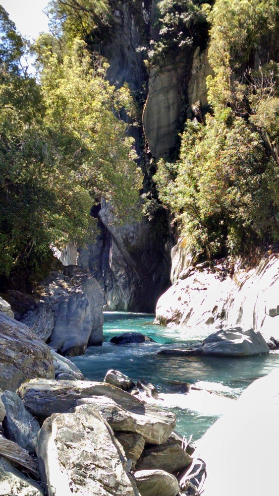
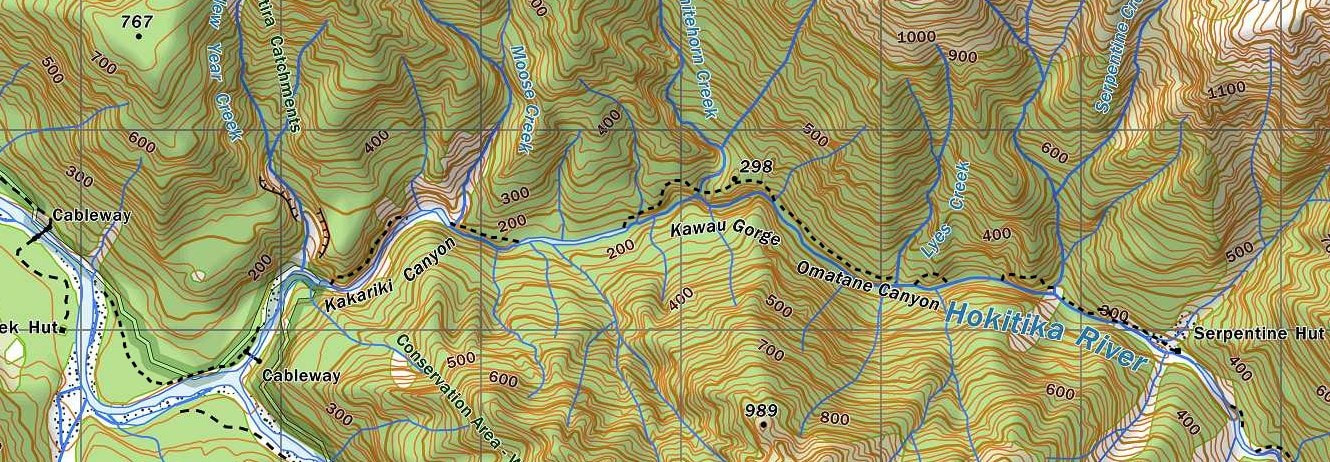
The Serpentine route starts at the bush edge on a gravel bar around 500m up the Hokitika River from the Rapid Creek cableway. It passes through a flat area of lowland forest and re-joins the riverbed just below New Year Creek. The riverbed is followed to the mouth of the Kakariki Canyon where the second section of track starts at the site of an old cableway (not the one marked on the map). It climb/ sidles on rough and undulating terrain across the bush faces above the Canyon. Some old regenerating slips are crossed, last and most recent of which is cairned and cruise-taped, before the trail drops back to the river. After Moose Creek the track re-enters the bush and sidles up around the beautiful slow-flowing upper Kakariki Canyon. A reasonable and easy stretch of river travel follows to the next section of track that skirts the Kawau Gorge. The track climbs steeply, drops down to the lip of the Whitehorn Creek waterfall, then climbs again to point 298m. After this a level section is followed by a descent down a very steep, narrow rib to the unnamed creek at the top entrance of the Kawau Gorge. A short sidle across some regenerating slips leads to the next section of track which takes you to Lyes Creek. This section of track isn't shown yet on NZ Topomaps.
The Serpentine route starts at the bush edge on a gravel bar around 500m up the Hokitika River from the Rapid Creek cableway. It passes through a flat area of lowland forest and re-joins the riverbed just below New Year Creek. The riverbed is followed to the mouth of the Kakariki Canyon where the second section of track starts at the site of an old cableway (not the one marked on the map). It climb/ sidles on rough and undulating terrain across the bush faces above the Canyon. Some old regenerating slips are crossed, last and most recent of which is cairned and cruise-taped, before the trail drops back to the river. After Moose Creek the track re-enters the bush and sidles up around the beautiful slow-flowing upper Kakariki Canyon. A reasonable and easy stretch of river travel follows to the next section of track that skirts the Kawau Gorge. The track climbs steeply, drops down to the lip of the Whitehorn Creek waterfall, then climbs again to point 298m. After this a level section is followed by a descent down a very steep, narrow rib to the unnamed creek at the top entrance of the Kawau Gorge. A short sidle across some regenerating slips leads to the next section of track which takes you to Lyes Creek. This section of track isn't shown yet on NZ Topomaps.
 Upper Omatane Canyon - route up onto old trackline
After Lyes Creek there is a short river section under a bluff to where the track exits up an old slip at the entrance of the lower Omatane Canyon. It climbs steeply, sidles a bit, then drops back to the river. Another 500m stretch of boulderhopping follows to a huge active slip at the start of the upper canyon. The cairns and cruise-tape placed here usually have a short shelf life, but if there, lead diagonally up to a side-scree that comes in on the TL of the main one. Climb up this for a short distance and exit up a gut on its TL. This will connect you with the old trackline just above where it vanishes into space. The track climb/ sidles above the canyon for a bit before dropping back to the river at Serpentine Creek. The bottom entrance is also actively eroding at the moment. After crossing the creek, the river is followed for 500m to a small unnamed canyon with a short, steep climb around it. The top portion of track has slipped away, and a narrow bench has been grubbed across the top of the slip face.
The track drops back to the river at a small recently blown-out creek and the riverbed is followed for 500m to a last section of track that leads to the Hut. Allow a good 8-10 hours travel from the Hokitika road end to Serpentine Hut. The unnamed side-creek next to the Hut can be problematic to cross in inclement weather due to its steepness and volume. It is named as Serpentine Creek on the earliest maps, but the next creek downriver got to bear this name at some point. The route was checked and trimmed in places, flood damage repaired, and windthrow skirted in April 2024, but it's constant action up there, so be prepared for plenty of rough stuff and new messy bits.
Access down from Frisco Hut was restored in 2015. The track leaves Frisco and sidles across the bush faces for just under a kilometre onto a broad spur with montane forest. It traverses some open marshy hollows with mossed-over tarns to point 910m from where it drops down the ridge on the TL of Nogo Creek to the river. There are animal and vegetation survey plots from the 1980s on the ridge every 400m with tagged trees and permolat markers on aluminium stakes. Follow the riverbed from Nogo Creek to Bonar Creek where a short piece of track takes you to another river section. There follows a steep climb up and around a waterfall and small gorge. The climb was avoidable in the past at low flows by fording the river upstream of the fall and re-crossing at the mouth of the gorge further down (around E1443912/ N5235376 (BV18 439 354)). Unfortunately, the river is running quite swiftly there at the moment and to save you having to backtrack, I'd recommend not bothering to try this for the time being. From the gorge to Serpentine Hut is river travel with a couple of short, tracked, bush detours. Allow 3-4 hours currently for the journey from Frisco. The tracked sections were checked and trimmed in places in April 2024 and are in good shape.
The scrub around the chopper pad at Serpentine was retrimmed at the same time.
Type
Serpentine was one of four unique 4-bunk NZFS B48 designs built in Westland in 1957. Dave Tiller and Jock Fisher erected the Hut from materials dropped in by fixed-wing aircraft. The Serpentine design was a forerunner of the standard S81 model and owes much of its layout to Department of Internal Affairs structures built in the area earlier in the decade. The Hut had flat-iron cladding on both walls and roof. The roof iron was replaced by corrugated iron at some point in the 1960's. In 1983 the NZFS did some major renovations on the Hut including removing the fireplace and installing a wood burner and replacing some piles and framing.
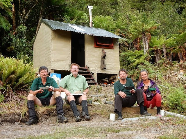 Serpentine Work Crew 2015
Condition
Serpentine survived a period of zero maintenance between 1983 and 2004 in very good shape. It had its exterior repainted and resealed, and some of the less solid framing replaced in the summer of 2003/4 by DOC. By 2014 the original silver pine piles were rotting out at ground level and needed replacing. They were uncemented and only went down 10-15cm into the soil. In 2015 most were replaced, concreted in, and diagonally braced. Some flat-iron flanges were added to protect the tops of some of the piles that were protruding out from the base of the wall. The roof had a thick layer of red lichen removed and was repainted, along with the end wall and other areas of the iron cladding that needed it. A rotten purlin under the clearlight on the south side of the roof was replaced and along with a damaged section of clearlight. Some sealing was done around the bottom of both door studs. The work crew comprised me, Alan Jemison, Paul Reid, and Joke de Rijke.
The woodburner installed by the NZFS is a very simple design that was constructed at their workshop back in 1983. It still works great and is hot enough to cook on. Water is from the river or a plastic container next to the Hut. An outside bath was added as an extra feature and a rudimentary toilet constructed. Some of the cladding overlaps have started lifting a bit and need sealant inserted. Red algae is starting to appear again on the exterior end wall and roof. The Hut has a supply of rat and mouse traps. should the need arise, however don't leave anything edible out to encourage them, this shouldn't be an issue. And please cut more firewood than you use.
Tops Routes into Serpentine
It is possible to access to Serpentine over the Diedrichs Range from Mullins Hut via the upper TL branch of Mullins Creek. Exit the Creek at the waterfall at E1446515/ N5237253 (BV19 465 373), up the small steep-side creek on the TL at the foot of the fall. Climb to the 1600m mark on the SE ridge of the low peak of Mt O'Connor and sidle across the basin under the middle and high peaks. A conspicuous bench can be followed over to the low point between Mt O'Connor and point 1718m. Drop from the crest of the Range into the Hokitika at around E1445682/ N5236537 (BV19 457 365). and head down the prominent SW running spur below. The top of this descent is very steep and may require ice axes in winter and spring. The spur was once tracked from the scrubline down to Serpentine Hut and had an NZFS animal and vegetation survey line superimposed on it in the mid 1980s, however it is now unfollowable. A few bits of permolat may still be found here and there, but it's essentially a bush-bash down to the river. The first couple of hundred vertical metres of track were cut up from the Hut in 2017.
Another option is a traverse Mt O'Connor and a descent of Serpentine Creek. The Creek's upper basin is easy travel with good campsites. Further down the going is rough with waterfalls that have to be skirted through steep bush. This route has been mentioned three times in the last 35 years in the Serpentine hut books. Two of the accounts were neutral, the third and most recent (2011) is highly scathing of its value as a route.
Both of the above routes can be used to access Serpentine from Gerhardt Spur Biv. A traverse of Jumble Top can be avoided by dropping off Gerhard Spur around the 1300m contour into the top fork in the headwaters of Diedrichs Creek (at E1445315/ N5240625 (BV19 453 402)). Climb up onto the Diedrichs Range up via the TL fork of the Creek. The top of the climb is steep with crumbling rock and care needs to be taken here. Ice axes may be needed on this pitch during the colder months. Allow around 10 hours to do the traverse from Gerhardt Biv.
Repairs still needed.
Some the rear piles protrude out past the cladding and had in the past allowed water to seep under to the bearers and create a few patches of rot. We were able to add cladding overlaps and brace the bearers along the areas of rot, which were relatively small. Over the long term some of the bearers will need replacing. One short bearer under the Hut has borer and needs replacing. The piles we didn't replace are OK, but may need looking at over the longer term. A floorboard in the middle of the Hut is a bit spongy and needs an extra brace underneath. A bit more sealing needs to be done around the external cladding and the algae scrubbed off.
Provisions on Site
One foldout deckchair, one axe, one shovel, two buckets (one plastic, one aluminium), two basins (one plastic, one aluminium), a broom, a frypan, a large casserole pan, a pot, and utensils and cups, a small crowbar, a small gin trap, two rat traps, a mouse trap, a small hand saw, a car jack (no winding arm), a small set square, a plastic scrubbing brush, a sealant gun, 2 hacksaw blades, 15kg cement, a wire brush, 8 litres of karaka acrylic, 9 litres of lichen acrylic, 7 litres of anti-rust primer, turpentine, 3 paint brushes, a paint roller and tray, 1.5 kg large jolt head nails, 40 10g x 25mm hex bolts (for securing the external wall cladding), 40 12g x 50mm hex bolts (for securing the roofing iron), 20 z-nails, 2 coach bolts, a small quantity of 6" nails, a small packet of fence staples, and some small flathead nails. There are a couple of rolls of No. 8 wire under the Hut, one 900m long treated pile and half a sheet of clearlight.