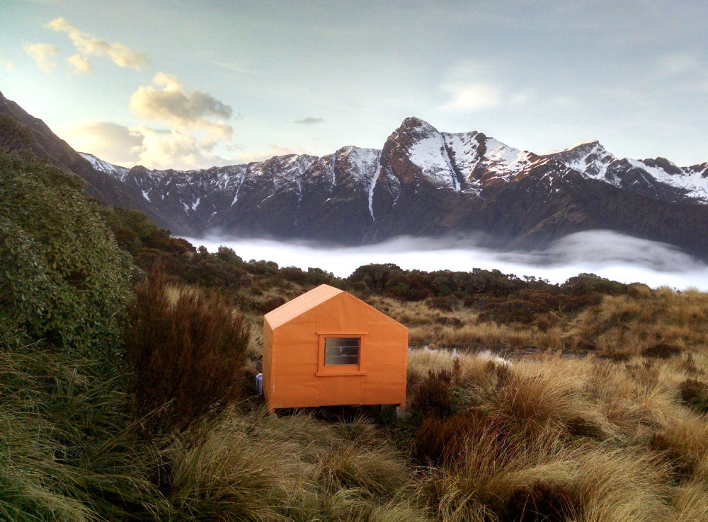
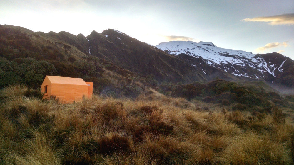
Mikonui Spur Biv
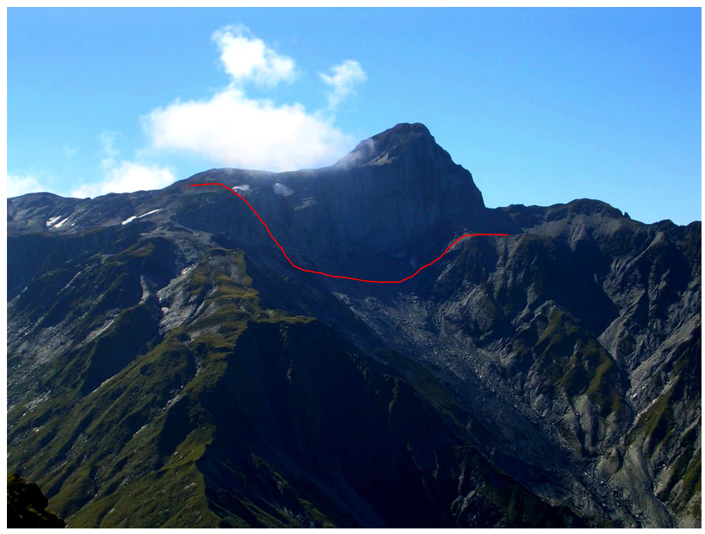
 Couloir route from Bowen down to Dickson Saddle
Maintenance Status
Mikonui Spur Biv and the track to it are currently designated as fully maintain. Ted Brennan of Bold Head noticed not much was happening to the Biv, got a letter of understanding from the Department of Conservation, and he and his partner Annie Hughes self-funded a repaint. The Biv will continue to be maintained by DOC over the longer term. The access track was recut and marked by DOC in March 2018 and is in good condition.
Location
Mikonui catchment. Grid Ref: E1431895/ N5233867 (BV18 319 339). Map BV18. 1130m altitude. Mikonui Spur Biv is located on a bench at the scrub/ tussock boundary on Mikonui Spur. The Spur divides the Dickson and Mikonui rivers and has superb views of Remarkable Peak and out across the coastal plains to the Tasman Sea. The Biv can be accessed in a day from the Mikonui roadend and receives a steady, low-level flow of mostly overnight visitors (around 6-12 parties per year). Many try to fit in a climb of Mt Bowen, and the more adventurous various traverses of the Whitcombe/ Mikonui tops.
Access
Access to the Mikonui valley is via the Totara Valley Road, a very windy 16kms of gravel that is still maintained by the local Council. The road has had a hammering from multiple extreme weather events and is no longer advisable for 2WD. Access to Mikonui Spur Biv from the roadend is via the TR of the Mikonui. There is a short section of track around a bluff, then an hour or so up the river flats to where the Dickson River comes in. Ford the Mikonui River around 400m up from the Dickson confluence and head up an old flood channel (now well grassed)for 200m to the track entrance at the toe of the hill. The track climbs steeply onto a low terrace initially, then veers ENE up a broad bush spur, climbing steadily to around 850m.
The spur flattens here and the track wends its way through the montane/ sub-alpine zone to where it steepens again and becomes more sharply defined. A steep climb follows and leads onto a flat bench with tussock and scattered scrub at point 1116m. There is a dip into tussock gully and a short climb through a band of alpine scrub onto the bench where the Biv is located. The track is currently (November 2019) in excellent order and well-marked for almost all its length. At the very bottom end the DOC trackcutters must have run out of gas, puff or spray, and the small stuff hasn't been cut back. The trail is still OK to follow on this bit. Allow 4-5 hours from the Mikonui roadend to Mikonui Spur Biv. A ford of the Mikonui is required if coming up the TR from the roadend. If travelling from Mikonui Flat Hut, a ford of the Dickson is necessary. Both of these are OK at normal flows, with the easiest crossing being the Mikonui above the Dickson Confluence.
Type
Mikonui Spur Biv was built in 1960 and was one of the last of the New Zealand Forest Service two-person B49 designs with a flat-iron roof. It is a basic shell with a couple of mattresses, but no bunks, and single perspex window at the far end. There is no toilet. A tarn next to the Biv provides drinking water. There is marginal cellphone reception here.
Condition
Mikonui Spur Biv is currently in reasonably dry, sound condition. DOC replaced the piles and roof in 2004. Ted and Annie rust-proofed, painted and sealed the Biv in April 2019. It is now rescue orange courtesy of Dulux. They also re-affixed a brace near the door and put in some hex-screws where needed on the iron cladding. There is still a bit of moisture coming down one of the rafters and creating a wet area where it meets the top plate, a bit of dampness on the bottom plate under the window, and one corner and one wall stud are a bit damp. I checked the outside cladding around these areas and it's tight and looks well sealed, so it's a bit of a mystery as to how it's getting in. The door is also sticking quite badly. An old crow bar under the Biv is useful for popping it open.
Routes
Mt Bowen is accessed up the Spur through a band of scattered alpine scrub, then open tussock. At 1400m the ridge narrows and there is a short vertical section, with plenty of small alpine scrub handholds. Above the tussock line some fairly easy scree slopes lead to the summit. These are usually snow covered in winter and spring and ice axes and crampons may be necessary on the summit ridge during the colder months. Chamois are often encountered on the climb up and the Biv logbook has accounts of tahr being spotted near the summit.
Traverses of Mt Bowen to Miserable and Misty Ridges are possible. There is a steep exposed section between the 1650 and 1550m contour of Miserable Ridge on which care needs to be taken. Lower down Miserable Ridge becomes a bit of a misnomer for this large flat high-altitude tussock bench sprinkled with large tarns and idyllic camp spots. Explorer Hut can be accessed from a prominent western side spur and an old NZFS track down to Explorer Saddle. The spur branches off Miserable Ridge at GPS E14234491/ N5235688 and drops steeply through an alpine scrub band that has had a rough track cut through it in most places. This leads to a flattish tussock bench from Pt. 1177m to Pt. 1122m, from where a cut and marked track leads down to Explorer Hut. This section was recut in 2021.
An old NZFS track from point 1433m down to Rapid Creek was recut in 2017. It goes down the spur on the TL of Illusion Creek to the bottom entrance where the Rapid Creek swingbridge used to be (E1437875/ N5235422). The top end through the alpine scrub is vague in places and zigs about a bit. It is fairly roughly cut from here down but OK to follow. A local possumer has done a bit of work trimming the scrub in the sub-alpine band. Penny Webster is interested in tidying up the rest of the route. The short section up Rapid Creek from is a mix of DOC track and open streambed.
Misty Ridge and the top of Noisy Creek basin can be accessed by dropping down the couloir from the low point between Mt. Bowen and Sentinel Peak. The section of ridge between Noisy Creek Saddle and Misty Ridge has a couple of small, exposed notches between points 1648m and 1686m which can be done without a rope but are a bit marginal in terms of handholds. The alternative is a longish detour down Noisy Creek to around the 1400m contour, then back up the ridge to point 1686m. Once on Misty Ridge the travel is easy with good visibility or GPS. The Ridge forks at 1500m and the much better-defined North fork drops into the headwaters of Rapid Creek, while the main ridge running NE, drops down a broad, indistinct tussock face. There is a cairn near the correct drop-off around E1436655/ N5232338 (BV18 367 323).
Further down the ridge becomes more distinct, flattens and kinks East at point 1303m. There is a good-sized tarn and campsite 500m SE of point 1303m and more tarns and camp spots on the NE side of the Mt Browne summit. An old NZFS tops track provides access off Mt Browne down into Rapid Creek, entering the creek just downriver a bit from where the swingbridge used to be before DOC removed it. The top entrance of the track is at 1110m, E1438431/ N5233700 (BV18 384 337) and is not well defined. The track was recut and permolatted by me in 2018-19. It is still easy to follow, is well marked, but has quite a bit of windfall and is starting to overgrow a bit.
From Mt Bowen you can also continue over Sentinel Peak and down the spur on the TR of Noisy Creek basin. There is a very spacious rock biv on the TR of the basin, located roughly on the 1200m contour on the slopes above the creek. A track leads from the lip of the basin down a steep spur on the TL of Noisy Creek to the Cropp River junction in the Whitcombe. This track is fully maintained by DOC and was last cut in March 2018. The track has waratahs at the top and still in good nick down to about the 300m contour where it disappears in some shitty fern glades and windthrow. You are only 200m from Noisy Creek at this point and it may be best to continue down the creekbed from here to the Cropp River. The track start at the bottom may be difficult to locate.
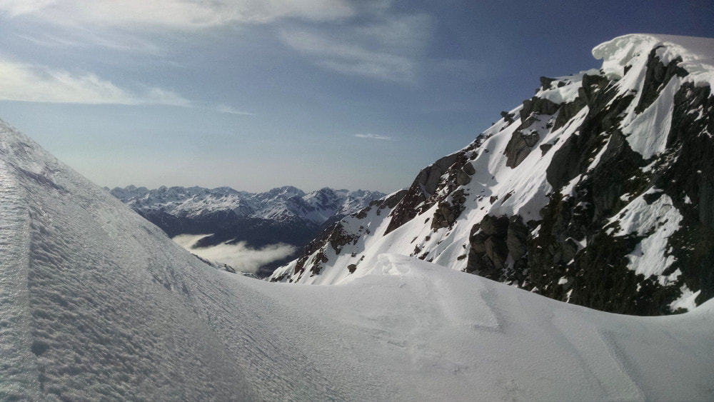
An old NZFS track from the Noisy Creek tops down through the alpine scrub into the Cropp Basin is probably no longer followable in its mid-section. Alternative access into the Cropp basin is possible down the couloir that drops from the low point between Mt Bowen and Sentinel Peak towards Dickson Pass. It has snow in it all year round, is steep, and would require ice axes, crampons, and possibly a rope for some of the year. In summer and autumn, the rib on the TL of the couloir is usually snow-free and a steep, but not too tricky scramble to get down. Drop off the rib into the couloir around the 1600m contour and sidle over onto the main ridge across a steep scree. Take care on this bit, as it's exposed and would be icy when snow covered. Drop from the flat area on the main ridge between point 1625m and Dickson Pass down the spur that separates Reckless Torrent and Snowy Stream. Drop into Snowy Stream around 1230m and climb onto the spur on its TR. The ridge forks at the 1180m contour and either fork can be used to access Cropp basin. A short scrub-bash is necessary in both cases near the bottom.
Mikonui Spur Biv and the track to it are currently designated as fully maintain. Ted Brennan of Bold Head noticed not much was happening to the Biv, got a letter of understanding from the Department of Conservation, and he and his partner Annie Hughes self-funded a repaint. The Biv will continue to be maintained by DOC over the longer term. The access track was recut and marked by DOC in March 2018 and is in good condition.
Location
Mikonui catchment. Grid Ref: E1431895/ N5233867 (BV18 319 339). Map BV18. 1130m altitude. Mikonui Spur Biv is located on a bench at the scrub/ tussock boundary on Mikonui Spur. The Spur divides the Dickson and Mikonui rivers and has superb views of Remarkable Peak and out across the coastal plains to the Tasman Sea. The Biv can be accessed in a day from the Mikonui roadend and receives a steady, low-level flow of mostly overnight visitors (around 6-12 parties per year). Many try to fit in a climb of Mt Bowen, and the more adventurous various traverses of the Whitcombe/ Mikonui tops.
Access
Access to the Mikonui valley is via the Totara Valley Road, a very windy 16kms of gravel that is still maintained by the local Council. The road has had a hammering from multiple extreme weather events and is no longer advisable for 2WD. Access to Mikonui Spur Biv from the roadend is via the TR of the Mikonui. There is a short section of track around a bluff, then an hour or so up the river flats to where the Dickson River comes in. Ford the Mikonui River around 400m up from the Dickson confluence and head up an old flood channel (now well grassed)for 200m to the track entrance at the toe of the hill. The track climbs steeply onto a low terrace initially, then veers ENE up a broad bush spur, climbing steadily to around 850m.
The spur flattens here and the track wends its way through the montane/ sub-alpine zone to where it steepens again and becomes more sharply defined. A steep climb follows and leads onto a flat bench with tussock and scattered scrub at point 1116m. There is a dip into tussock gully and a short climb through a band of alpine scrub onto the bench where the Biv is located. The track is currently (November 2019) in excellent order and well-marked for almost all its length. At the very bottom end the DOC trackcutters must have run out of gas, puff or spray, and the small stuff hasn't been cut back. The trail is still OK to follow on this bit. Allow 4-5 hours from the Mikonui roadend to Mikonui Spur Biv. A ford of the Mikonui is required if coming up the TR from the roadend. If travelling from Mikonui Flat Hut, a ford of the Dickson is necessary. Both of these are OK at normal flows, with the easiest crossing being the Mikonui above the Dickson Confluence.
Type
Mikonui Spur Biv was built in 1960 and was one of the last of the New Zealand Forest Service two-person B49 designs with a flat-iron roof. It is a basic shell with a couple of mattresses, but no bunks, and single perspex window at the far end. There is no toilet. A tarn next to the Biv provides drinking water. There is marginal cellphone reception here.
Condition
Mikonui Spur Biv is currently in reasonably dry, sound condition. DOC replaced the piles and roof in 2004. Ted and Annie rust-proofed, painted and sealed the Biv in April 2019. It is now rescue orange courtesy of Dulux. They also re-affixed a brace near the door and put in some hex-screws where needed on the iron cladding. There is still a bit of moisture coming down one of the rafters and creating a wet area where it meets the top plate, a bit of dampness on the bottom plate under the window, and one corner and one wall stud are a bit damp. I checked the outside cladding around these areas and it's tight and looks well sealed, so it's a bit of a mystery as to how it's getting in. The door is also sticking quite badly. An old crow bar under the Biv is useful for popping it open.
Routes
Mt Bowen is accessed up the Spur through a band of scattered alpine scrub, then open tussock. At 1400m the ridge narrows and there is a short vertical section, with plenty of small alpine scrub handholds. Above the tussock line some fairly easy scree slopes lead to the summit. These are usually snow covered in winter and spring and ice axes and crampons may be necessary on the summit ridge during the colder months. Chamois are often encountered on the climb up and the Biv logbook has accounts of tahr being spotted near the summit.
Traverses of Mt Bowen to Miserable and Misty Ridges are possible. There is a steep exposed section between the 1650 and 1550m contour of Miserable Ridge on which care needs to be taken. Lower down Miserable Ridge becomes a bit of a misnomer for this large flat high-altitude tussock bench sprinkled with large tarns and idyllic camp spots. Explorer Hut can be accessed from a prominent western side spur and an old NZFS track down to Explorer Saddle. The spur branches off Miserable Ridge at GPS E14234491/ N5235688 and drops steeply through an alpine scrub band that has had a rough track cut through it in most places. This leads to a flattish tussock bench from Pt. 1177m to Pt. 1122m, from where a cut and marked track leads down to Explorer Hut. This section was recut in 2021.
An old NZFS track from point 1433m down to Rapid Creek was recut in 2017. It goes down the spur on the TL of Illusion Creek to the bottom entrance where the Rapid Creek swingbridge used to be (E1437875/ N5235422). The top end through the alpine scrub is vague in places and zigs about a bit. It is fairly roughly cut from here down but OK to follow. A local possumer has done a bit of work trimming the scrub in the sub-alpine band. Penny Webster is interested in tidying up the rest of the route. The short section up Rapid Creek from is a mix of DOC track and open streambed.
Misty Ridge and the top of Noisy Creek basin can be accessed by dropping down the couloir from the low point between Mt. Bowen and Sentinel Peak. The section of ridge between Noisy Creek Saddle and Misty Ridge has a couple of small, exposed notches between points 1648m and 1686m which can be done without a rope but are a bit marginal in terms of handholds. The alternative is a longish detour down Noisy Creek to around the 1400m contour, then back up the ridge to point 1686m. Once on Misty Ridge the travel is easy with good visibility or GPS. The Ridge forks at 1500m and the much better-defined North fork drops into the headwaters of Rapid Creek, while the main ridge running NE, drops down a broad, indistinct tussock face. There is a cairn near the correct drop-off around E1436655/ N5232338 (BV18 367 323).
Further down the ridge becomes more distinct, flattens and kinks East at point 1303m. There is a good-sized tarn and campsite 500m SE of point 1303m and more tarns and camp spots on the NE side of the Mt Browne summit. An old NZFS tops track provides access off Mt Browne down into Rapid Creek, entering the creek just downriver a bit from where the swingbridge used to be before DOC removed it. The top entrance of the track is at 1110m, E1438431/ N5233700 (BV18 384 337) and is not well defined. The track was recut and permolatted by me in 2018-19. It is still easy to follow, is well marked, but has quite a bit of windfall and is starting to overgrow a bit.
From Mt Bowen you can also continue over Sentinel Peak and down the spur on the TR of Noisy Creek basin. There is a very spacious rock biv on the TR of the basin, located roughly on the 1200m contour on the slopes above the creek. A track leads from the lip of the basin down a steep spur on the TL of Noisy Creek to the Cropp River junction in the Whitcombe. This track is fully maintained by DOC and was last cut in March 2018. The track has waratahs at the top and still in good nick down to about the 300m contour where it disappears in some shitty fern glades and windthrow. You are only 200m from Noisy Creek at this point and it may be best to continue down the creekbed from here to the Cropp River. The track start at the bottom may be difficult to locate.
An old NZFS track from the Noisy Creek tops down through the alpine scrub into the Cropp Basin is probably no longer followable in its mid-section. Alternative access into the Cropp basin is possible down the couloir that drops from the low point between Mt Bowen and Sentinel Peak towards Dickson Pass. It has snow in it all year round, is steep, and would require ice axes, crampons, and possibly a rope for some of the year. In summer and autumn, the rib on the TL of the couloir is usually snow-free and a steep, but not too tricky scramble to get down. Drop off the rib into the couloir around the 1600m contour and sidle over onto the main ridge across a steep scree. Take care on this bit, as it's exposed and would be icy when snow covered. Drop from the flat area on the main ridge between point 1625m and Dickson Pass down the spur that separates Reckless Torrent and Snowy Stream. Drop into Snowy Stream around 1230m and climb onto the spur on its TR. The ridge forks at the 1180m contour and either fork can be used to access Cropp basin. A short scrub-bash is necessary in both cases near the bottom.
 Remarkable Peak detour on the Cropp Basin side
Those wanting to traverse the tops to Healey Creek Hut or Top Tuke Hut need to detour around Remarkable Peak's imposing, vertical eastern ridge. A sidle is possible on the Cropp side from BV18 320 301 across at 1540m and up an easy narrow gut to BV18 316 301 on the flat section SW of the summit. Continue past pt. 1673m up onto the start of Galena Ridge. Healey Spur drops from here down a steep rib of tussock and loose rock when snow-free. There is a dip at the bottom of this, followed by a short razor-backed section that can be traversed with care, or avoided by dropping onto the tussock slopes on the Healey Creek side and sidling between the 1500 and 1600m contours. It is necessary to climb back onto the Spur either SE or NW of point 1643m due to deep slots that prevent a direct sidle down to the Hut.
Travel along Galena Ridge from Remarkable Peak to point 1794m very straightforward in good conditions. Top Tuke Hut is accessed down the prominent ridge that runs West from point 1864m. There is one short exposed section near the top of the ridge that can be negotiated without too much difficulty. The spur forks further down and the SE branch is taken. Drop from this in a southerly direction into the basin below. A route through a band of bluffs down into the Tuke River can at the lip of the basin on the TR, next to the top of the waterfall. A small notch here, around E1428665/ N5227080 (BV18 287 271), provides access down onto some steep rib with a small creek on the TR. The creek can be followed down towards the Hut, which is visible from the top of the bluffs in fine weather. Sidle out on the creek where it flattens and make a direct bee-line through patchy scrub to the Hut.
There used to be an old NZFS track from the 1300m contour on Mikonui Spur down the ridge that separates Kaka Creek and the upper Mikonui. It would have emerged somewhere opposite the start of the track to Explorer Saddle. It was permolatted originally, but was never maintained. In terms of ease of travel, or usefulness as a route, it probably differs little from the untracked ridges in the vicinity.
Repairs Needed
The door might need a bit planed off the edges to stop it sticking. The roof leaks would best be investigated during a bit of extreme weather.
Provisions on site
The ubiquitous DOC hearth shovel and brush. Two fold-up chairs. There is an old crowbar on site. Ted left a 3m length of 50x50 H3 and a 3 m length of 75x50 pine stored under the Biv a box inside with the remaining paint, nails, hand-drill, scraper, screwdriver and a few other things.
