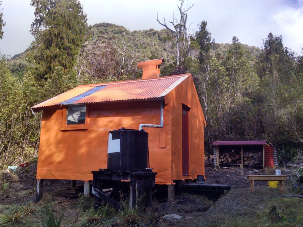
Explorer Hut
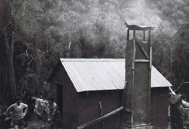 Explorer 1964 - Gerry Field and Keith Lane (NZFS)
Maintenance status
Explorer Hut was designated as minimal maintenance by the Department of Conservation in 2004 but didn't get any attention following this. By 2017 it was in need of some fairly urgent repair work. Alastair Macdonald of Permolat got hold of some Outdoor Recreation Consortium funding (Back Country Trust's forerunner) and got most of this maintenance done in 2017. The access tracks and routes to Explorer are not officially maintained but have been kept open by volunteers. A team led by Jane Morris did a BCT funded recut of the tops tracks on either side of the Hut as well as some Hut repairs in 2021/ 22. Explorer Hut gets around 20 visits a year, mostly from the Mikonui side, with a few parties coming via the Doctors Creek route from the Hokitika and more recently, over the Bald Hill Range. A fair proportion of the hut's visitors are hunters, and there are quite a few deer in both the upper Mikonui and Doctors catchments.
Location
Map BV18. Grid Ref: E1431670/ N5236720 (BV18 317 367). Altitude 460m. Explorer Hut is located on Douglas Saddle between the Mikonui and Doctors Creek catchments, both of which run along the Great Alpine Fault. Explorer Hut is a relatively easy 2-3 hour walk from the Mikonui roadend or 4-5 hours from the Hokitika side via Doctors Creek, making it a great little overnighter. There is a great feeling of deep-bush ambience around the Hut and ruru, kea, weka, kaka, kakariki and the odd friendly bush robin provide the acoustics and entertainment. There are whio down in Doctors Creek and powelliphanta shells can be found around Douglas Saddle and on the Bald Hill Range tracks. For those visiting in summer, mozzie nets or repellent are recommended, as the little critters come down the chimney at night.
Access
The route to Explorer Hut from the Mikonui roadend is mostly river travel with two short, tracked sections. The first of these is around the TL of a small gorge just upstream from the Dickson River confluence and was retrimmed in March 2022. A ford is required at the top of the gorge to the TR. This has altered a little since the flood of December 2019 and would be difficult now if flows were higher than normal. It's river travel from here with the odd ford necessary including one to the TL to avoid a bluff just below the Kaka Creek confluence. From here up it is a question of finding the best line, fording where appropriate. Ford the Mikonui to the TR at Explorer Creek (the Mikonui veers sharply south-east here). Head up Explorer Creek for around 400m, exit on the TL and follow a grassy corridor 200m to the toe of the hill. The track heads uphill here at around E1431280/ N5235970 (BV18 313 360). It climbs steeply up the bush faces for around 20 minutes, then sidles a short distance around to Douglas Saddle. The Hut is located in a small clearing backing on to podocarp forest, just above the Saddle. The tracked portions of the route were trimmed and marked in 2020 and checked again in 2022.
The route into Doctors Creek from the Hokitika side is over Murray Saddle and was recut and marked in 2020 and given another trim in 2022 and 23. The start of the route can be accessed from the top end of the Hokitika Gorge tourist circuit. A section of track leads to the riverbed which can be followed to Minnow Creek. If the Hokitika is low, it is quicker to walk from the locked gate at the roadend on the TR of the Hokitika and ford the Hokitika as near to Minnow Creek as a reasonable ford can be found.
Follow the creekbed of Minnow Creek initially to where the track exits on the TR (E1436288/ N5239724) and climbs steeply up the bush faces on the TR of the Creek. The terrain levels at around 240m altitude and the track drops back into Minnow Creek and follows it for 1.5km towards Murray Saddle. The track crosses the Saddle and drops into Surveyors Creek which is followed down to the large side-creek on the TL at E1433529/ N5239561. Head up the side-creek for around 400m to where the track exits on the TL and climbs over a wedge of terrace before dropping into Doctors Creek. Follow the river to the Smith Gorge, which is tracked on the TR, then a section of boulderhopping to a second small gorge that is also tracked on the TR. The river is followed from here to Bramhall Creek. The going is bouldery and the multiple crossings required are very easy at normal flows. The track up to the Saddle starts 140m up Bramhall Creek on the TL and goes up the ridge between Doctors and Bramhall Creeks for 5-10 minutes before levelling and passing through an area of podocarp forest. This last bit is in need of a tidy up. Allow 4-6 hours from Minnow Creek to Explorer Hut. Add an extra hour if you are traveling up the riverbed from the Hokitika Gorge.
An open clearing on the Saddle just below the Hut provides chopper access.
Type
Explorer Hut is a New Zealand Forest Service 4-bunk S81 design with open fire, probably built in the early 1960's, perhaps a bit earlier. Derrick Field recalls visiting it in 1964 and says it had already a few years on it at that stage. Explorer was lined, had the cupboard on one side of the door removed, and a roof-fed water tank added at some point. It has a toilet, which tends to be a splasher because of the high water-table. The chimney was replaced, had a cowling added, and the hearth was renewed in 1971. The fireplace smokes unless the end louvre is opened.
 Explorer work party 2017
Condition
DOC repainted and resealed Explorer, repaired the roof, and replaced the water tank and stand in March 2004. Permolat started taking more of an interest in Explorer around 2015 when it became clear that DOC wasn't going to be doing any more work on it. In February 2017 Alastair and his team; Alan Jemison, Liz Stephenson, Mike O’Connell, Geoff Spearpoint, and Antony Johnson, went in and re-piled the Hut, replacing and adding joists and bearers where necessary. Flashings were added at pile level where necessary. Repairs to the chimney and chimney flashing were made. The Hut was re-roofed and had new side flashings and ridging put on. A section of rotten floor, floor plate, studs and dwangs in the cupboard in the SE corner were replaced, and the cupboard removed. Repairs were made to rotten sections of the window frame, wall and floor on the end wall, and some rotten sections of floor on either side of hearth replaced. The Hut exterior was repainted, a small woodshed built, and drains dug around the Hut to prevent water running underneath. I went in a few days later and finished some framing and floor repairs in the NW corner and gave the exterior its second coat. Emma Richardson gave the interior and a clean and first coat at the end of 2017. I did a bit more sealing in early 2018. In 2021 Jane's crew put in a new fire surround and finished off the interior ply work.
Routes
There is an alternative route up Doctors Creek from the Hokitika River confluence, which is longer and rougher going than the Murray Saddle route. It takes around an hour to reach Doctors Creek from the Hokitika Gorge using an old bulldozer track on the TL of the River. Follow Doctors Creek up to the first TR side-creek upstream of Shadow Stream. Follow this up to around the 200m contour line, then exit over a low saddle and continue sidling along the bush faces well above Doctors Creek until the large flat above the first gorge is reached. Drop back into the Creek and boulderhop to the gorge just upstream from Surveyors Creek. This can be negotiated on the TR. Pick up the Murray Saddle route at the next river flat and continue as per this to Explorer. Allow a full day for this route.
An old NZFS track up Fraser Peak from Explorer Hut was recut and marked by Jane's crew in 2021. The track starts on the NW edge of the helipad and heads up the lower slopes of the Bald Hill Range, crosses a small creek, and climbs steeply onto a flat shelf at around 680m. From here it climbs steeply up the bush faces onto the eastern ridge of Fraser Peak. From the 940m mark on the ridge the track continues through scattered scrub and open patches. There are great views from Fraser Peak of Mt Bowen, Remarkable Peak and Ragged Peak, and there are three old, toppled trig beacons near the summit. A rock biv off the side of the track around the 675m contour (NZTM2000 E1431450 N5237218 (BV18 315 372)) and marked with permolat isn't great shakes and has no handy water supply. Allow 3-4 hours to reach the summit of Fraser Peak, and two hours back down to Explorer Hut.
 Bald Hill access track
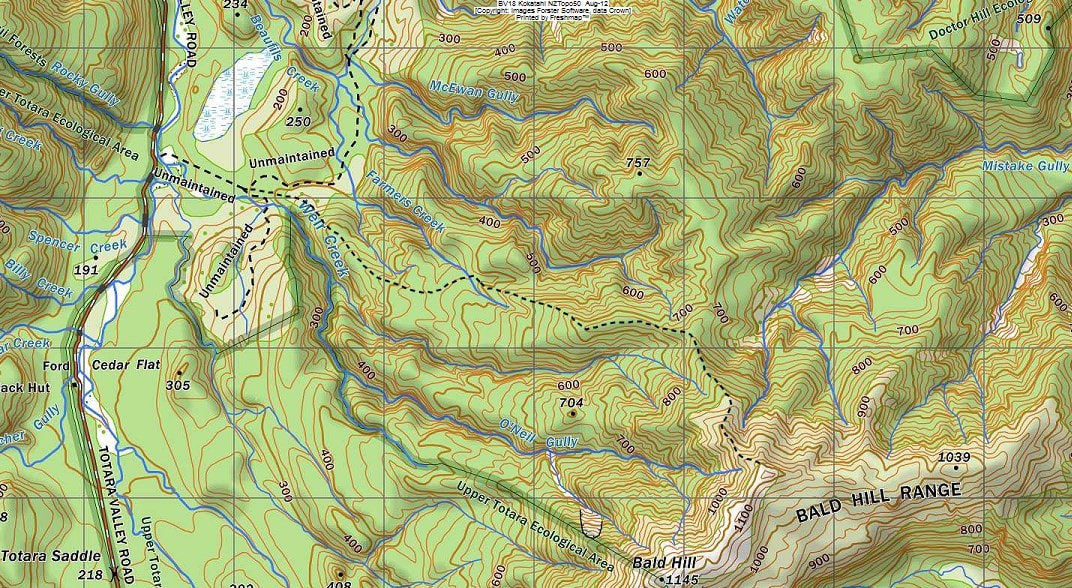
There is a track from the Totara Valley up onto Bald Hill, which offers an alternative tops traverse, or circuit to and from Explorer. An old miner's bench track up to a stamper battery site at around 450m in the Farmers Creek catchment was opened up by Glenn Johnston in 2016. On old cullers track that went from here to the tops was recut and marked by Glenn and me in 2017. Access to the start of the track is from the Totara valley road at a routered sign at a bend in the road between Rocky Gully and Long Creek. Ford the Totara to the route entrance opposite the sign and continue through some grassy clearings to an old logging road at (E1425612/ N5241273). This is followed for around 800m to the start of the miners' track where the road veers North (E1426083/ N5241057). The track goes up the ridge dividing Farmers and Weir Creeks to the battery site. The battery is gone but there are some old pipes lying around. The cullers route starts from here and heads SE up onto a prominent ridge that leads up to the open tussock and it is easy travel along the crest of the Range to Bald Hill. The section between Bald Hill and Fraser Peak was opened up by a Permolat team in March 2022 and the main track down to the Totara trimmed and marked shortly after. Allow 7-9 hours for the traverse from the Totara to Explorer.
An old NZFS track onto the Miserable Ridge tops starts directly behind Explorer Hut. It was recut for the first time in many decades by volunteers in 2017-18 and given a thorough trim and marking to Point 1122m by Jane's team in July '21. It climbs steeply up the bush faces onto a more defined ridge that connects with a flat area of open tops at the 1100m mark. There are a few small tarns on this section which leads to a second steep pitch up onto Miserable Ridge proper. The route transects a second band of alpine scrub through which a trail has been roughly cut in most places. Miserable Ridge is a misnomer and has its origin in a failed attempt to graze sheep up there in the 1800s. This high-altitude tussock bench sprinkled with large tarns and idyllic camping spots is a place of great beauty and awesome views.
It is possible to do a tops circuit from here over Mt Bowen to Mikonui Spur Biv. The Miserable Ridge side of the traverse to Mikonui Biv has one steep quite exposed section between 1550 and 1650m.
It is also possible drop off Pt. 1433m down an old NZFS track on the TL of Illusion Creek to Rapid Creek Hut in the Hokitika. This track was recut and marked in 2017 and starts at the bottom where the Rapid Creek swingbridge used to be (E1437875/ N5235422). The top end through the alpine scrub is vague in places and zigs about a bit. It is fairly roughly cut from here down but OK to follow. A local possumer has done a bit of work trimming the scrub in the sub-alpine band. Penny Webster is interested in tidying up the rest of the route. The short section up Rapid Creek from is a mix of DOC track and open streambed.
From Mt Bowen you can also continue over Sentinel Peak and down the spur on the TR of Noisy Creek basin. There is a very spacious rock biv on the TR of the basin, located roughly on the 1200m contour on the slopes above the creek. A track leads from the lip of the basin down a steep spur on the TL of Noisy Creek to the Cropp River junction in the Whitcombe. This track is fully maintained by DOC and was last cut in March 2018. The track is poled at the top and still in good nick down to about the 300m contour where it disappears in some shitty fern glades and windthrow. You are only 200m from Noisy Creek at this point and it may be best to continue down the creekbed from here to the Cropp River. The track start at the bottom may be difficult to locate.
An old NZFS track that went directly up onto Mikonui Spur from the upper Mikonui River, opposite the start of the track up to Douglas Saddle has not been maintained from the early 1970's, perhaps earlier, and is not followable anymore. The best and most reliable way to access Mikonui Spur Biv from Explorer is to head back down the Mikonui to the maintained access track that starts at the Dickson River.
Work Still To be done.
The cladding on the NW corner is still fastened with small flathead nails that will need replacing with tech screws in the medium term.
Provisions on Site
An extra mattress, two small trestle seats, a pot, pan, a billy, a teapot, a broom, a spare broom handle, three plastic plates, an axe, two galvanised buckets, a plastic bucket, a small coal shovel, a hearth brush and some rat poison. There is a paint tray, roller and extension, a large and a small paintbrush. There is a small quantity of Tech-screws, some Janola, white topcoat paint (5 litres), water-based white primer (10 litres), water-based white (8 litres), Exterior Orange (3.5 litres) a scrubbing brush There are two spare louvre panes under the bunk. Under the Hut are the bits of cladding and roofing iron that were removed in the renovations.
