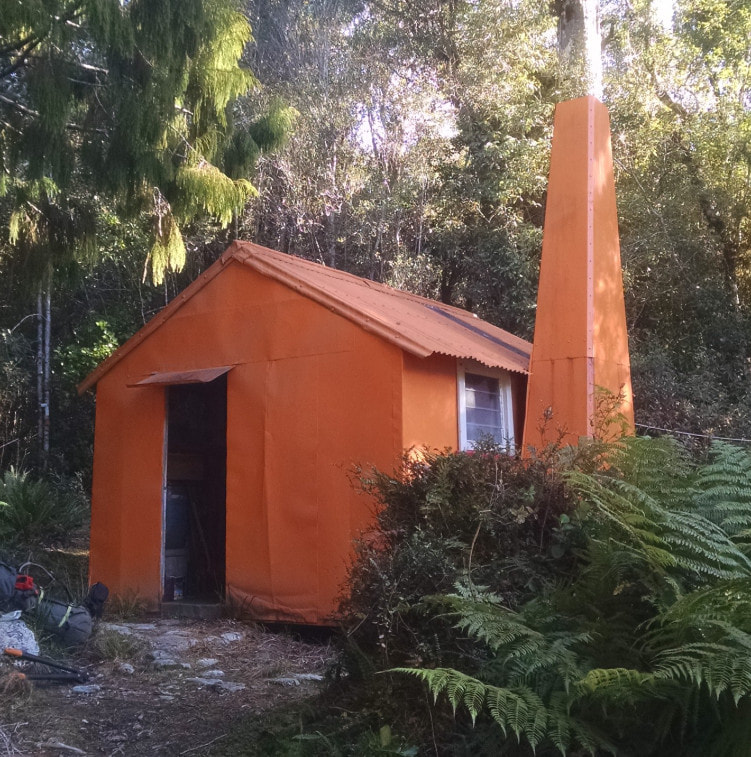
Mid Styx Hut

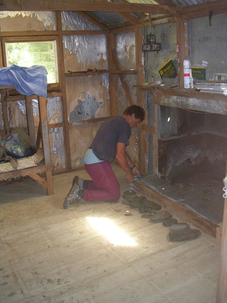 Mark Mellsop-Melssen doing hearth repairs in 2009
Maintenance Status
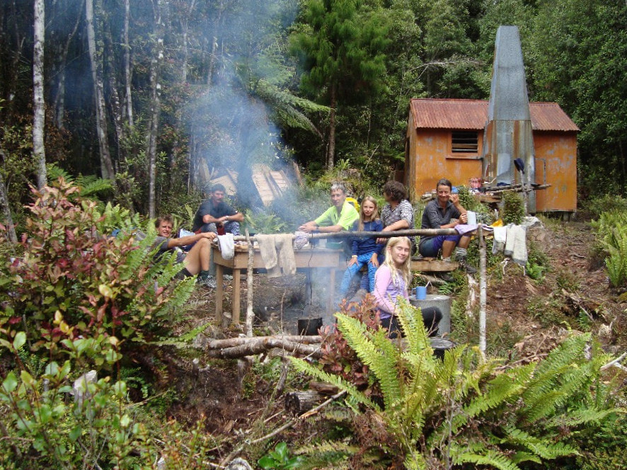
Mid Styx Hut is a maintain by community project. No work was done on the Hut from the 1970's until 2004 when the Department of Conservation designated it as minimal maintenance, by which stage the piles and floor had largely rotted out. Mid-Styx was Permolat's second maintain-by- community project with Mark Mellsop-Melssen as signatory. In 2009 he and a group Permolat volunteers went in and re-piled and re-floored the Hut. The exterior was repainted in 2014. Permolat volunteers also recut and marked the access tracks to the Hut, and a tops track behind it onto the Browning Range. When a series of major floods seriously damaged the Grassy Flat track on the TR of the Styx valley in 2019, DOC began rerouting it up the TL of the valley incorporating Mid Styx in the loop, Potential problems with fords have led to a halt in the proceedings on both sides of the valley although at last report the Department was still encouraging trampers to use the Mid Styx bypass when heading up that way.
Location
Styx valley. Map BV19. Grid Ref: E1456688/ N5249300 (BV19 567 493). 460m altitude. Mid Styx is located on a high bush terrace midway up the TL of the Styx valley. Mature podocarp, rata, and hardwood forest surround the Hut and give it great deep-bush ambience. The bird life is prolific with tui, kakariki, pipipi, weka and ruru providing the soundtrack. The Hut is only a couple of hours from the roadend, but was historically bypassed due to being on the opposite side of the Styx River to the main valley track. Overnight visits and drop-ins to Mid Styx increased noticeably after it was profiled on this site, repaired, and had its access tracks recut. This has further increased with DOC's re-routing of main valley access.
Access
Access to Mid Styx Hut requires at least one ford of the Styx River, so the weather is always going to be an important factor for intending visitors. The Styx often cuts in against a shingle bluff just above where the old farm track ends, but currently you can wade around it no trouble at normal river levels. and continue up the TR. Travel is along grass flats, the old Browning Pass bench track where it hasn't been scoured out, and the riverbed where it has. You'll need to ford to the TL before the river narrows and becomes swifter and pick up the official DOC route. Once on the TL it is quicker in some places just to bomb up the riverbed, particularly where the track has been scoured out. Climb back onto the track just below Tyndall Creek and head up Tyndall Creek for just over a kilometre (to around the 400m contour line). At this point a track exits on the TR and climbs steeply up onto the bush terrace above. This section was recut by Eigill Wahlberg in 2023. The track flattens at the top of the climb and continues along the terrace for half an hour to the Hut. Tyndall Creek is likely to be uncrossable following heavy rain. Allow 2.5-3 hours to reach Mid Styx from the road end.
The turnoff to Mid Styx from the upper valley is around an hour downriver from Grassy Flat Hut. There is a newly cut DOC track down to the river just below an unnecessary detour around a shingle bluff. Ford and continue down the TL to the large unnamed side-creek at E1457077/ N 5249672. The track up to the Hut climbs steeply onto the terrace on the TL of this creek and follows along its edge for 20 minutes before veering west for a 1/2 kilometre to the Hut. This bit was recut by Eigill in 2023.
Type
Mid Styx is a standard NZFS S81 four-bunk design with open fire, built in the 1960's. The floor, piles, joists and bearers at Mid Styx were completely replaced in the 2009 working bee, and the hearth re-concreted. The cupboard and wood box vestibule were removed during the renovations. There is no toilet currently and water is from pools in a very small creek next to the Hut. The bunks are wire-netting with new DOC fireproof mattresses. Mark built a small woodshed for the Hut in 2013 with materials salvaged from the renovations. Glenn Johnston and Chris Steel have been helping Mark with the work on the Hut.
Condition
As a follow on from the 2009 maintenance Mid Styx had its exterior painted and the clearing enlarged in 2014. DOC Hokitika supplied 12 litres of orange paint through the Dulux scheme for the painting. The framing and cladding above floor level is original and surprisingly well-preserved despite the years of zero maintenance. The original fireplace was cemented on top of a pile of rocks and there are some gaps around the base that would be big enough for rodents to get in. The iron backing between hearth and chimney is rusting out and DOC consider that there is some fire-risk even though there is nothing combustible in the gaps. The sheet of clearlite in the roof is discoloured and past its best-by date. Take some mosquito coils if visiting in summer as the critters come down the chimney when the fire goes out. The Hut currently has a mouse infestation. Some poison bait was left on a nail in June.
Routes
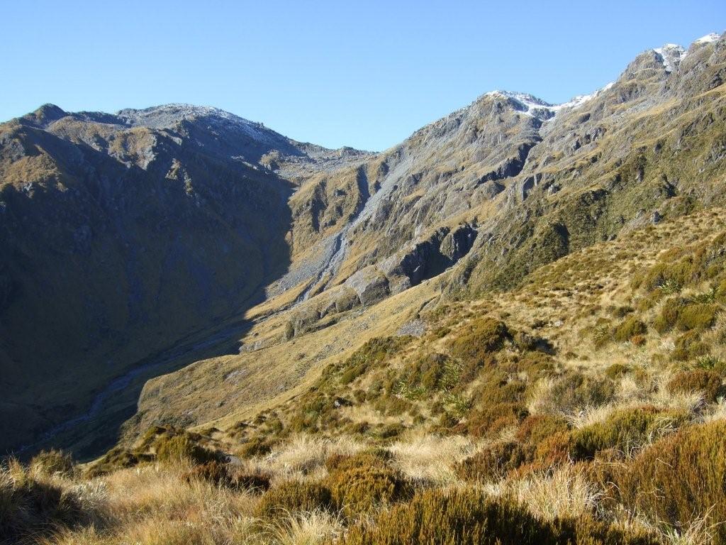
An old NZFS track 10 minutes upriver from the Hut provides access onto the Browning Range. It was reopened by Permolat volunteers in 2010, recut and marked by Glenn Johnston and Greg Ross in February 2014, and done again to the 1100m contour by Indy Hawthorne in June '24. From the turnoff the track follows the TL terrace of the big unnamed side-creek before connecting to the ridge on the creek's TL and following it up to the open tops. The top section of the track is very steep and awkward to stay on. An alternative is to sidle West into a gut that's equally steep, but a bit more open and head up that. Allow two hours from Mid Styx Hut to the tussock where there is a good tarn and campsite. It takes around two hours from here to the top of Cairn Peak. The top end of the track is overgrown in places with flax and scrub. Indy plans on heading back at some point and doing this bit.
Mid Styx Hut is a maintain by community project. No work was done on the Hut from the 1970's until 2004 when the Department of Conservation designated it as minimal maintenance, by which stage the piles and floor had largely rotted out. Mid-Styx was Permolat's second maintain-by- community project with Mark Mellsop-Melssen as signatory. In 2009 he and a group Permolat volunteers went in and re-piled and re-floored the Hut. The exterior was repainted in 2014. Permolat volunteers also recut and marked the access tracks to the Hut, and a tops track behind it onto the Browning Range. When a series of major floods seriously damaged the Grassy Flat track on the TR of the Styx valley in 2019, DOC began rerouting it up the TL of the valley incorporating Mid Styx in the loop, Potential problems with fords have led to a halt in the proceedings on both sides of the valley although at last report the Department was still encouraging trampers to use the Mid Styx bypass when heading up that way.
Location
Styx valley. Map BV19. Grid Ref: E1456688/ N5249300 (BV19 567 493). 460m altitude. Mid Styx is located on a high bush terrace midway up the TL of the Styx valley. Mature podocarp, rata, and hardwood forest surround the Hut and give it great deep-bush ambience. The bird life is prolific with tui, kakariki, pipipi, weka and ruru providing the soundtrack. The Hut is only a couple of hours from the roadend, but was historically bypassed due to being on the opposite side of the Styx River to the main valley track. Overnight visits and drop-ins to Mid Styx increased noticeably after it was profiled on this site, repaired, and had its access tracks recut. This has further increased with DOC's re-routing of main valley access.
Access
Access to Mid Styx Hut requires at least one ford of the Styx River, so the weather is always going to be an important factor for intending visitors. The Styx often cuts in against a shingle bluff just above where the old farm track ends, but currently you can wade around it no trouble at normal river levels. and continue up the TR. Travel is along grass flats, the old Browning Pass bench track where it hasn't been scoured out, and the riverbed where it has. You'll need to ford to the TL before the river narrows and becomes swifter and pick up the official DOC route. Once on the TL it is quicker in some places just to bomb up the riverbed, particularly where the track has been scoured out. Climb back onto the track just below Tyndall Creek and head up Tyndall Creek for just over a kilometre (to around the 400m contour line). At this point a track exits on the TR and climbs steeply up onto the bush terrace above. This section was recut by Eigill Wahlberg in 2023. The track flattens at the top of the climb and continues along the terrace for half an hour to the Hut. Tyndall Creek is likely to be uncrossable following heavy rain. Allow 2.5-3 hours to reach Mid Styx from the road end.
The turnoff to Mid Styx from the upper valley is around an hour downriver from Grassy Flat Hut. There is a newly cut DOC track down to the river just below an unnecessary detour around a shingle bluff. Ford and continue down the TL to the large unnamed side-creek at E1457077/ N 5249672. The track up to the Hut climbs steeply onto the terrace on the TL of this creek and follows along its edge for 20 minutes before veering west for a 1/2 kilometre to the Hut. This bit was recut by Eigill in 2023.
Type
Mid Styx is a standard NZFS S81 four-bunk design with open fire, built in the 1960's. The floor, piles, joists and bearers at Mid Styx were completely replaced in the 2009 working bee, and the hearth re-concreted. The cupboard and wood box vestibule were removed during the renovations. There is no toilet currently and water is from pools in a very small creek next to the Hut. The bunks are wire-netting with new DOC fireproof mattresses. Mark built a small woodshed for the Hut in 2013 with materials salvaged from the renovations. Glenn Johnston and Chris Steel have been helping Mark with the work on the Hut.
Condition
As a follow on from the 2009 maintenance Mid Styx had its exterior painted and the clearing enlarged in 2014. DOC Hokitika supplied 12 litres of orange paint through the Dulux scheme for the painting. The framing and cladding above floor level is original and surprisingly well-preserved despite the years of zero maintenance. The original fireplace was cemented on top of a pile of rocks and there are some gaps around the base that would be big enough for rodents to get in. The iron backing between hearth and chimney is rusting out and DOC consider that there is some fire-risk even though there is nothing combustible in the gaps. The sheet of clearlite in the roof is discoloured and past its best-by date. Take some mosquito coils if visiting in summer as the critters come down the chimney when the fire goes out. The Hut currently has a mouse infestation. Some poison bait was left on a nail in June.
Routes
An old NZFS track 10 minutes upriver from the Hut provides access onto the Browning Range. It was reopened by Permolat volunteers in 2010, recut and marked by Glenn Johnston and Greg Ross in February 2014, and done again to the 1100m contour by Indy Hawthorne in June '24. From the turnoff the track follows the TL terrace of the big unnamed side-creek before connecting to the ridge on the creek's TL and following it up to the open tops. The top section of the track is very steep and awkward to stay on. An alternative is to sidle West into a gut that's equally steep, but a bit more open and head up that. Allow two hours from Mid Styx Hut to the tussock where there is a good tarn and campsite. It takes around two hours from here to the top of Cairn Peak. The top end of the track is overgrown in places with flax and scrub. Indy plans on heading back at some point and doing this bit.
 The basin above the Browning Biv tops track: Photo Glenn Johnston 2010
It is possible to access Browning Biv using this route and traversing the
the tussock basin in the unnamed side-creek. Climb from the basin up onto the ridge bounding its TR and sidle from the 1700m contour around and down to Lathrop Saddle. Follow the poled route from here down to Browning Biv. Allow 5-6 hours from Mid Styx Hut to Browning Biv using this route, which is longer and more arduous than if you were to use the main valley track.
A crossing of the Browning Range from Mid Styx to Top Crawford Hut is something fitter types may like to consider. Access is via the tops track and the basin in the unnamed side-creek. Cross the Browning Range at the low point in head of the creek (E1458390/ N5246493 (BV19 584 465)) and drop down to the cirque with tarns on the Crawford side. The tarns are usually snow covered for a good portion of the year. There is an open gut just below the cirque that provides easy access into the creek catchment below. Follow the creek down into the Crawford basin. Allow 6-7 hours for the crossing in good conditions. Ice axes and crampons should be carried during the colder months.
A traverse of the Browning Range and down Whitehorn Ridge to Crawford Junction Hut is also possible from Mid Styx. The Range is relatively easy travel in late summer and autumn but would probably require snow gear in the colder months. A vertical pitch on the approaches to Tyndalls Knob can be sidled under on the south side. An old tops track down Whitehorn Spur to Crawford Junction Hut is very overgrown and not followable on the lower faces. You'd be looking at a 10-hour plus day for this traverse.
Repairs Needed
The hearth backing would benefit from further work or replacement. The external chimney cladding is still OK but may need some attention longer-term. A toilet will hopefully be built at some point, and it has been suggested that a cowling be made for the top of the chimney although these can quite often cause the fire to smoke. The clearlite in the roof still needs replacing and adding another sheet further along the roof would lighten the hut up considerably. A bait station for rodents has been left at the hut and will need to be replenished from time to time.
Provisions on site
A stool, two shovels, three food tins, a broom, an axe, a hand saw, a hearth shovel and brush, some sheets in a sealed barrel, a coal bucket, and two large pots. There is some leftover paint, paint brushes, that can be used in the future for touch-ups.
