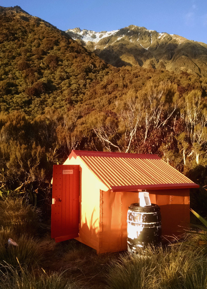
Browning Biv


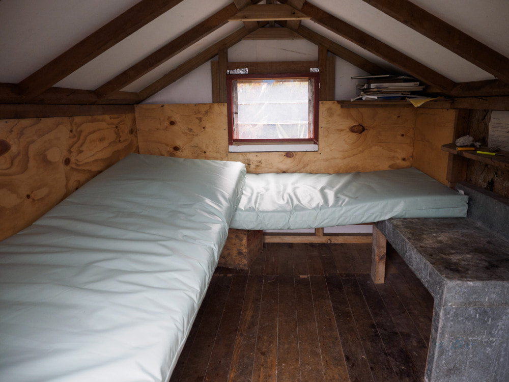 Browning Biv interior
Maintenance Status
Browning Biv and its access track are fully maintained by the Department of Conservation. In February 2020 some Back Country Trust funding was made available to allow Permolat volunteers to repaint the Biv and do some trackwork. DOC have recently been in and recut the access track.
Location
Styx catchment. Map BV19. GPS Ref: E1459182/ N5248255 (BV19 591 482). Altitude 1048m. Browning Biv is located on a ridge in the alpine scrub zone on the Browning Range. It has great views out over the Styx valley to the Newton Range and is most commonly used as a stopover on the Lathrop Saddle - Zit Saddle circuit. This is a reasonably popular tramp of medium difficulty. Browning Biv was maintained and kept in a homely fashion from 1986 to 2004 by Mark Crompton of Hokitika. This coincided with a period in which DOC wasn't particularly active maintenance-wise. Mark made numerous visits to the Biv while doing a snow retention study and made sure it stayed weatherproof and well provisioned. He made a compilation of old hutbook entries from the 1970's onward and left a copy at the Biv. The Lathrop - Zit circuit has become popular post covid times with over 30 parties passing through in 2022.
Access
The Browning Biv route is accessed from the Grassy Flat track in the Styx valley. The Styx valley route has suffered greatly from a series of extreme weather events in recent times and the old Browning Pass bench track on the TR has been taken out in a number of places. DOC is advising trampers to go via the Mid Styx Hut route on the TL, adding a good hour to the trip. It is still possible to go all the way up the TL using the old, benched track where possible or boulderhopping where it has been washed away. A fairly gnarly bush bash over some bluffs is necessary just above Tyndall Creek where the river has cut right in. Above this the track remnants or riverbed are pretty good travel, with more of the old bench intact as you get further up the valley.
When coming up the TL the Mid Styx detour can be avoided at low river levels by crossing back to the TR above Tyndall Creek and continuing up the original trackline where it isn't washed out. The best ford currently is around 200m upstream from Tyndall Creek (E1455138/ N5249878). This ford should definitely not be attempted if the river is running above normal levels. If this one isn't any good you may have to boulderhop upriver and find a place where it flattens and widens. For those using the Mid Styx route, the ford back to the TR is also prone to change. It is currently OK just below where the track drops back to the river. If not, you'll need to boulderhop upriver to find a better crossing. Don't attempt any of the crossings if the river is up.
The Browning Biv route starts at a routered sign at the bottom end of Grassy Flat. It crosses an open area with scattered scrub, then veers uphill through hardwood forest connecting with the unnamed access creek. The topo map has the track going up the TL of this creek however the creek is incorrectly marked, and the track goes up the TR. The creek has blown out at its lower end entered the forest in several spots and the entry and exit points to the track that have been obliterated have had flagging tape added. Further up the creekbed is followed to the 820m mark where a second section of track exits on the TL at GPS: E1459548/ N5248492. This leads up a steepish face through montane and alpine forest onto a bench just below the ridgetop, where the Biv is located. The track should be in good condition currently. Allow 1.5-2 hours from Grassy Flat to the Biv, or 7-8 hours from the Styx roadend.
An open knoll on the ridge 10 minutes above the Biv provides helicopter access.
Type
Browning Biv was built in 1961 and was one of the first of the NZFS B55 designs. It has a corrugated iron roof, a single louvre window at the back end, and two narrow sleeping platforms. There is one mattress and some sleeping mats and pillows. There is no toilet. Water is provided by a small roof-fed drum that was installed by Mark Crompton.
Condition
Browning Biv was re-piled, painted and re-sealed, and had some of its framing replaced by DOC in 2004. In 2016 there was another major lot of maintenance done. The roof and end walls were removed, reframed, papered, re clad and sealed. Some flooring and the bunks were replaced, and the bunk area lined. The ridging, window, and door and window flashings were replaced. Door stoppers and a door threshold were added. The vegetation around the Biv was cut back. It missed out on a paint job due to a hard helicopter drop which crushed the paint tins. The Biv was repainted by the Permolat crew in February 2020.
 Route down from Lathrop Saddle to the Top Crawford Basin
Routes
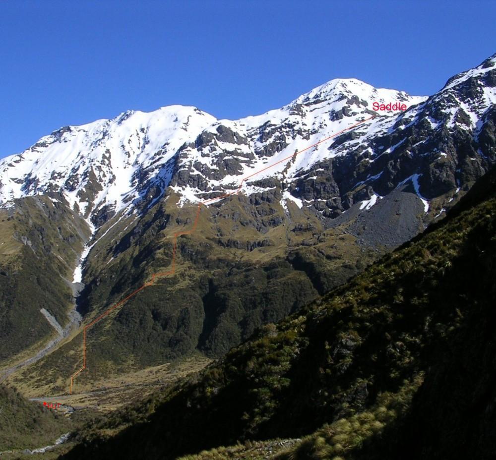
The route to Lathrop Saddle and Top Crawford Hut follows the ridge above the Biv. There is a cut track through the alpine scrub to the tussock. Some of the larger harakeke on this bit could do with cutting. From the scrub edge snow poles lead up the ridge which narrows and steepens considerably near the top. Lathrop Saddle is a spectacular U-shaped corridor with several tarns, two of which are of a reasonable size, and shattered house-sized boulders. At the end of the corridor the poles veer SE and sidle across some steepish screes to avoid a band of bluffs directly below the Saddle. The sidle is South-facing and usually snow covered until late spring. Conditions are often icy and ice axes and crampons need to be carried during the colder months. Around E1458920/ N5245773 (BV19 589 458) the poles veer downhill and follow a broad spur towards the basin. The spur bluffs out lower down and the route drops over and down a tussock face into the side-creek catchment on the TR of the spur. The route descends the slope parallel to the creek into the basin. Top Crawford Hut is on the TL of the TL fork of the upper Crawford and is clearly visible on the way down in fine weather. The travel time from Browning Biv to Top Crawford Hut is around 3-4 hours in good conditions.
Mt Lathrop is an easy climb from Lathrop Saddle, and the Browning Range is relatively straightforward all the way down to Tyndalls Knob. It would be possible to get from Browning Biv to Crawford Junction Hut in a long day and while an old tops track down Whitehorn Spur down to the Junction has long vanished you may be fortunate enough to pick up a good deer trail to avoid a bit of alpine scrub misery. The Crawford is usually pretty easy to ford at the foot of the Spur.
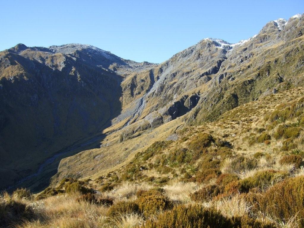 Tussock basin on Mid Styx traverse - Photo Glenn Johnston 2010
There is high-level route to Mid Styx Hut from Lathrop Saddle, although it's much quicker just to drop from the Biv down to the Styx valley and go downvalley to the Hut. Sidle from the Saddle at around the 1700m contour into the tussock basin at the head of the big unnamed side creek that flows down to the mid Styx. An old NZFS tops track goes down a ridge from the TL lip of the basin to Mid Styx Hut. The track can be picked up in the alpine scrub belt on the NW fork in the spur around the 1280m contour. Its top end is accessed down a steep gut on the spur's TL. The route was retrimmed up to the 1100m contour by volunteers in 2024. Although plans are afoot for this, the top section is still uncut, overgrown, and very steep. Allow 5-6 hours for the traverse.
Repairs Needed
None currently. The weather wasn't great during the 2020 paint job and the roof missed getting a second coat and could really do with one. The track from the Biv up through the alpine scrub could do with a trim in places.
Provisions On Site
Aside from the statutory DOC hand brush and shovel, and an NZFS aluminium basin, all the gear and provisions in the Biv were left there by Mark. There is a a small library, binoculars, hedge clippers, a bow saw, two flat files, a hammer, a wire brush, loppers, a knife, a scraper, a Stanley knife, a screwdriver, a small hacksaw, pliers, a slasher, and a first aid kit.
