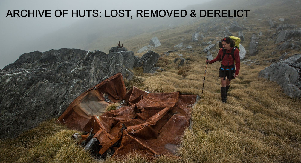
The following is an archive of some of the huts in the Central Westland area that have become derelict, been destroyed, or been removed. The listing is in alphabetical order.
Blue Duck Biv
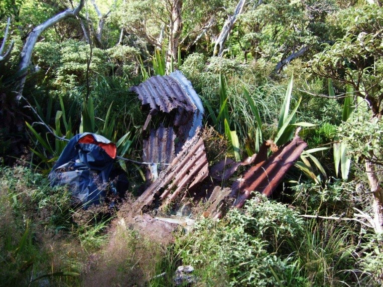
Blue Duck Biv, now derelict, is located on the tops on the TL of Blue Duck Creek in the Kokatahi valley. It was built by the New Zealand Forest Service in the period 17.10.58 to 31.01.59 according to a report to Merv O'Reilly from Alan Farmer. who also built Scottys Biv in the Taipo. John Bathgate who worked as a culler from 1969-72 mentioned visiting it in February 1972. Little was known of it, or its whereabouts for many years following this. Ted Brennan of DOC mentioned seeing a derelict Biv from a helicopter in the early 2000's and in 2016 Jim Masson spotted it from the crest of the Toaroha Range. Since then, it has been visited and photographed by a couple of parties. The Biv's roof and frame have collapsed, and it has obviously not been liveable for quite some time. It is located on the NZ Topo-50 BV19 map at around E1452940/ N5242446. The Biv site can be viewed on Google maps. Blue Duck Biv was a standard B49 structure with flat-iron walls and roof.
Blue Duck Biv, now derelict, is located on the tops on the TL of Blue Duck Creek in the Kokatahi valley. It was built by the New Zealand Forest Service in the period 17.10.58 to 31.01.59 according to a report to Merv O'Reilly from Alan Farmer. who also built Scottys Biv in the Taipo. John Bathgate who worked as a culler from 1969-72 mentioned visiting it in February 1972. Little was known of it, or its whereabouts for many years following this. Ted Brennan of DOC mentioned seeing a derelict Biv from a helicopter in the early 2000's and in 2016 Jim Masson spotted it from the crest of the Toaroha Range. Since then, it has been visited and photographed by a couple of parties. The Biv's roof and frame have collapsed, and it has obviously not been liveable for quite some time. It is located on the NZ Topo-50 BV19 map at around E1452940/ N5242446. The Biv site can be viewed on Google maps. Blue Duck Biv was a standard B49 structure with flat-iron walls and roof.

|
Cat Creek Biv
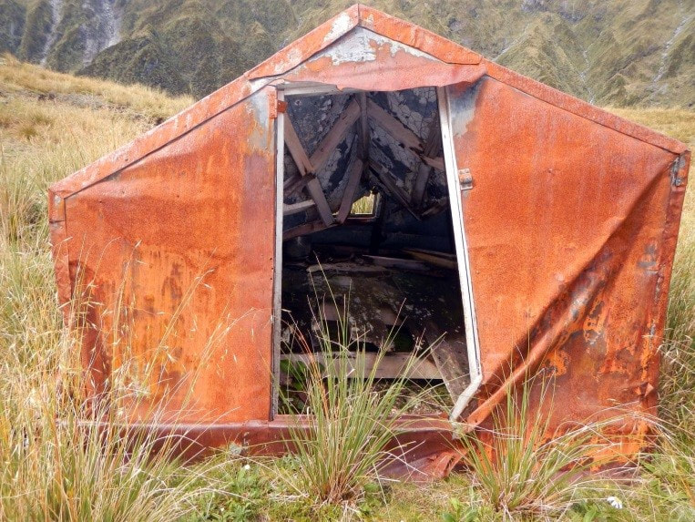
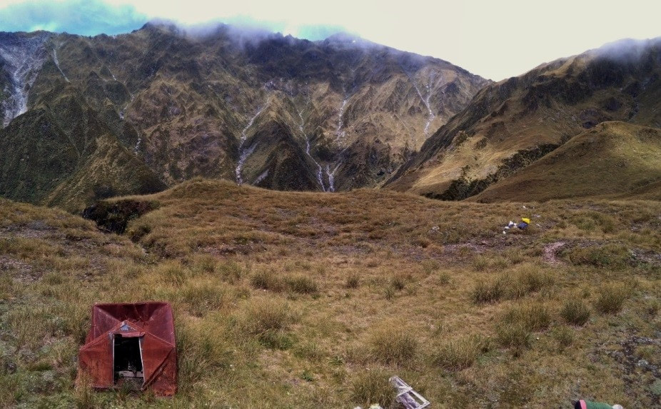
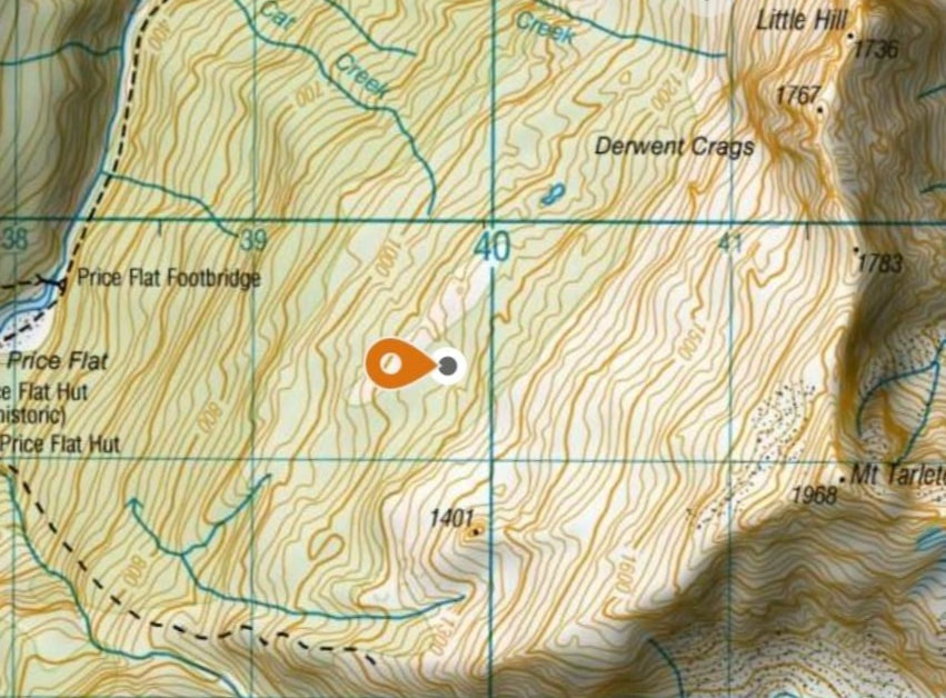
Cat Creek Biv was a two-bunk B55 design with corrugated iron roof that was located around the 1140m contour on the Whitcombe River tops between Vincent and Cataract creeks. It never appeared on any of the NZ topo maps and was destroyed in a storm sometime in 1974. A rudimentary shelter was constructed from its wreckage, possibly by NZFS workers. I visited the site in 1978, but the shelter wasn't appealing enough to be worth staying in. We accessed it via the tops track behind Price Flat Hut. The remains are still there in a creek gut at E1439812/ N5225395. There is a tarn just to the true left of the gut that is not marked on the topo map. |
|
Crane Creek Hut
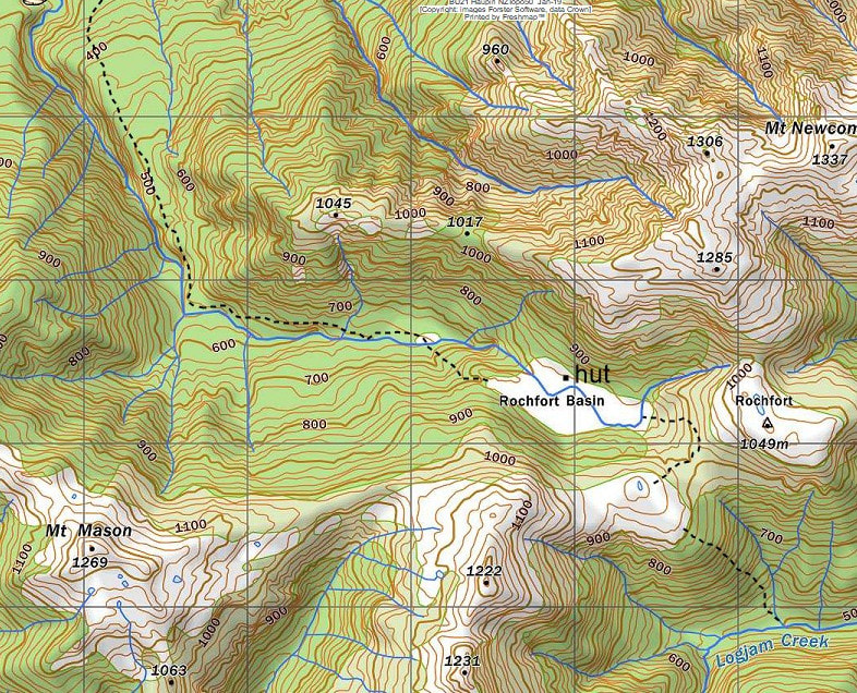
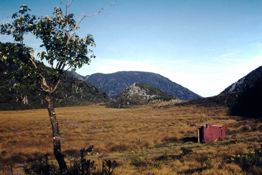
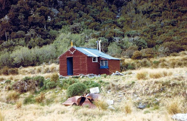
Crane Creek Hut was located in the Rochfort Basin at the head of Crane Creek. In Robin Quigg's dissertation, "Back-Country Huts: More Than A Roof Over Your Head," it states that Crane Creek Hut was an 8x8' structure built in 1956 by the NZFS and West Coast Branch of the NZDA. It was pre-cut and flown in, then lengthened in the early 1980's to 16x8'. The FS hoped that recreational hunters would have an impact on local deer numbers, and the NZDA considered the basin a safe place for their junior members to hunt. Rochfort basin is an impressive sub-alpine setting, however the Hut itself was considered quite unappealing, with few windows, and narrow, uncomfortable bunks. Crane Creek burned down some time after 1993.
Crane Creek Hut was located in the Rochfort Basin at the head of Crane Creek. In Robin Quigg's dissertation, "Back-Country Huts: More Than A Roof Over Your Head," it states that Crane Creek Hut was an 8x8' structure built in 1956 by the NZFS and West Coast Branch of the NZDA. It was pre-cut and flown in, then lengthened in the early 1980's to 16x8'. The FS hoped that recreational hunters would have an impact on local deer numbers, and the NZDA considered the basin a safe place for their junior members to hunt. Rochfort basin is an impressive sub-alpine setting, however the Hut itself was considered quite unappealing, with few windows, and narrow, uncomfortable bunks. Crane Creek burned down some time after 1993.

Cropp Hut
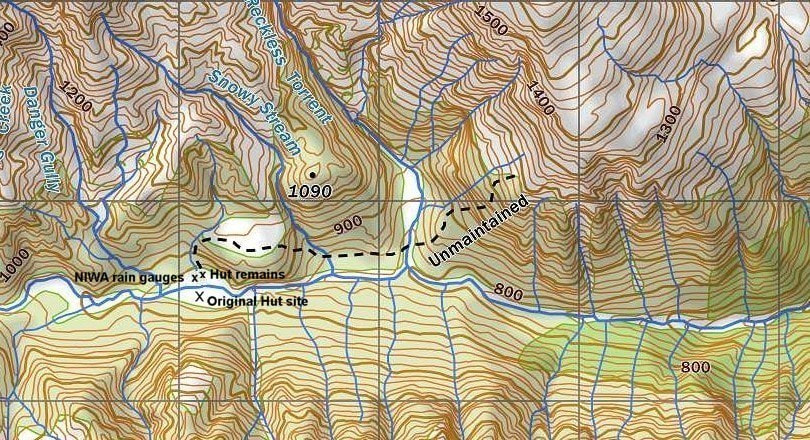
Cropp Hut was located in the Cropp basin in the Whitcombe valley on an idyllic river flat ringed by sub-alpine forest and with picturesque waterfalls coming down off Galena Ridge. There are some great high-level routes to the upper Waitaha and Mikonui catchments from the basin. Cropp Hut started its life as a standard six-bunk NZFS design with open fire. In January 1969 culler Greg Kohler found it with its chimney almost torn off by a recent storm. Colin Yeates and Peter Annett repaired and painted the Hut, possibly removing the chimney at the same time. In the mid 1970’s the Hut was blown off its piles and was repaired by Tony Newton and his workers. Reports of recurring wind and flood damage continued right through to the Hut's demise in 1995. Cropp Hut was used by the Ministry of Works Meteorological division from the late 1970's for rainfall and river flow monitoring (it was here that NZ's record for the heaviest rainfall in a 48-hour period, 1049mm, was recorded in 1995). The Department insulated and lined the hut and a coal range was installed by the NZFS in August 1981. Cropp Hut was hit by a flash flood in 1995 and a hutbook entry
later that year reports it being turned around off its piles, with a foot of sand inside and a tide mark 18 inches up the wall. DOC were intending to repair the Hut but discovered that the sodden batts in the walls had rotted the frame beyond salvation. Sections of iron cladding and frame were flown over to the flat on the TL of the River, and the rest burned. The remnants are still there a short distance from some NIWA meteorological equipment. The Permolat Group has suggested placing one of the old Bivs that was removed by DOC, back in the basin, but they're not keen on this idea. Pity! It's a fantastic location.


Diedrichs Creek Hut
Diedrichs Creek Hut was located on the TR of Diedrichs Creek on the frontal terraces of the Diedrichs Range. According to Warren Godfrey it had several names including the Internal Affairs Roadend Hut, Koiterangi Base, Forest Service Base, and Forest Service Roadend Hut. In the early days it was also sometimes referred to as Sam Godfrey's Hut, as it was, on, or adjacent to Godfrey’s land. Diedrichs Creek Hut is marked on a rough hand-drawn map of the area from 1932, updated by Len Boot of the NZFS in Hokitika in 1962. It was accessible by vehicle along a logging road to the Stopforth Sawmill which was a short distance further along the terrace. It survived through until the DOC days when it was burnt down, reputedly because the Department no longer wanted to maintain it.
Diedrichs Creek Hut was located on the TR of Diedrichs Creek on the frontal terraces of the Diedrichs Range. According to Warren Godfrey it had several names including the Internal Affairs Roadend Hut, Koiterangi Base, Forest Service Base, and Forest Service Roadend Hut. In the early days it was also sometimes referred to as Sam Godfrey's Hut, as it was, on, or adjacent to Godfrey’s land. Diedrichs Creek Hut is marked on a rough hand-drawn map of the area from 1932, updated by Len Boot of the NZFS in Hokitika in 1962. It was accessible by vehicle along a logging road to the Stopforth Sawmill which was a short distance further along the terrace. It survived through until the DOC days when it was burnt down, reputedly because the Department no longer wanted to maintain it.
Dynamite Hut
Dynamite (or Gelignite Hut) was located on Noti Raureka (Browning Pass) very close to the lip of the steep face on the Wilberforce side. It was a timber and corrugated iron structure with low walls and a steep roof. By 1971 the iron was largely rusted and the wood framing exposed. It gets a mention in Howard Keene's book "Going For Gold," published by DOC in 1995. On page 87 there is a photo of it taken in 1930 and credited to the Elva Cox collection. Stacked stones to protect the low walls are present in this photo.
Howard Keene dated the Hut from around 1905, although recycled materials from early prospecting camps may have been used in its construction. The West Cost Times reported a small subsidy of less than 5 pounds was paid by the Council to the constructors of a hut in the Wilberforce in 1905 which was probably Dynamite Hut. The Hut is rumoured to have been blown over the edge of the drop sometime in the early 1970's. Bits and pieces of it were salvaged to make a crude windbreak or shelter back on the top. Remnants of the hut can still be found, slightly off the trail, around 50m northeast of the descent.

Gunn River Hut
Gunn River Hut was a standard NZFS S70, 6-bunk design with an open fire. It was located on the scrubline at around 1070m mark on the TL of the Gunn River basin in the Whataroa catchment. Not sure when it was constructed, probably in the 1960s, and it blew off its piles, upside down, sometime in the 1970s. I don't know anyone who got to visit this one but was provided with some photos of it upended that were taken in 1979 and a more recent one. There was a track up to the Hut from near the Gunn/ Whataroa confluence which appears on the 1969 and '79 NZ topomaps. This was accessed by way of a swingbridge, also no longer there, at the bottom end of Barrowman Flat. The Hut itself never appeared on any maps but it's possible to approximate its location from the photos. Stan Peterson of Hokitika ran hunting safaris on the Price Range way back and probably used Gunn Hut. He got permission from the NZFS in 1985 to build a private hut on the next ridge over. This is now run by the NZ chapter of the Safari Club and is open to the public (See Stan's Hut) although quite a mission to get to on foot.
Gunn River Hut was a standard NZFS S70, 6-bunk design with an open fire. It was located on the scrubline at around 1070m mark on the TL of the Gunn River basin in the Whataroa catchment. Not sure when it was constructed, probably in the 1960s, and it blew off its piles, upside down, sometime in the 1970s. I don't know anyone who got to visit this one but was provided with some photos of it upended that were taken in 1979 and a more recent one. There was a track up to the Hut from near the Gunn/ Whataroa confluence which appears on the 1969 and '79 NZ topomaps. This was accessed by way of a swingbridge, also no longer there, at the bottom end of Barrowman Flat. The Hut itself never appeared on any maps but it's possible to approximate its location from the photos. Stan Peterson of Hokitika ran hunting safaris on the Price Range way back and probably used Gunn Hut. He got permission from the NZFS in 1985 to build a private hut on the next ridge over. This is now run by the NZ chapter of the Safari Club and is open to the public (See Stan's Hut) although quite a mission to get to on foot.


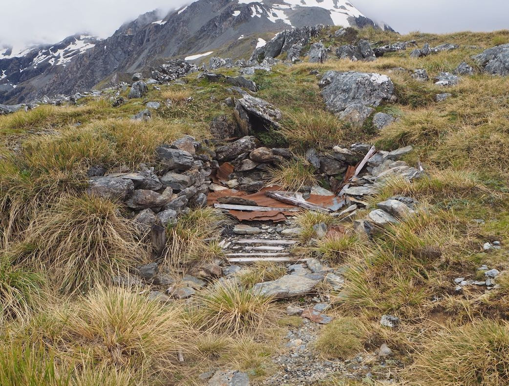
Jade Creek Hut
Jade Creek Hut in the Arahura valley, also known as the Red Hut, now derelict and dilapidated, sits on the TL of Jade Creek in the around 100m up from the Olderog Creek confluence. It looks reasonably intact at first glance; however, the door is gone, and a lot of the floor has rotted out. Its four bunks with wooden slats are still intact and dry, as is a lot of the wall and roof framing. The roof still appears to be keeping the rain out and the big overhang on the eves protects the walls to some extent. That hasn’t stopped moisture getting in at ground level, and visitors' rubbish gathering and moulding. Not particularly inviting a hovel but better than nothing if the creeks were in high flood and the rain bucketing down. This hut dates from 1963/4 and was a base for Westland Greenstone Ltd. Government cullers also made use of this hut until 1972. Like NZFS huts from the same era it has chicken wire and tar paper lining. There is an old rusted out coal range on the north wall and the flue is still standing. The one louvred window stand permanently open, and there is a disintegrating wooden cupboard in the NW corner. Old pots, cutlery, and other bits and pieces lie scattered around. One would need to be prepared to share the space with the plentiful local sandfly population if sheltering there.
Jade Creek Hut in the Arahura valley, also known as the Red Hut, now derelict and dilapidated, sits on the TL of Jade Creek in the around 100m up from the Olderog Creek confluence. It looks reasonably intact at first glance; however, the door is gone, and a lot of the floor has rotted out. Its four bunks with wooden slats are still intact and dry, as is a lot of the wall and roof framing. The roof still appears to be keeping the rain out and the big overhang on the eves protects the walls to some extent. That hasn’t stopped moisture getting in at ground level, and visitors' rubbish gathering and moulding. Not particularly inviting a hovel but better than nothing if the creeks were in high flood and the rain bucketing down. This hut dates from 1963/4 and was a base for Westland Greenstone Ltd. Government cullers also made use of this hut until 1972. Like NZFS huts from the same era it has chicken wire and tar paper lining. There is an old rusted out coal range on the north wall and the flue is still standing. The one louvred window stand permanently open, and there is a disintegrating wooden cupboard in the NW corner. Old pots, cutlery, and other bits and pieces lie scattered around. One would need to be prepared to share the space with the plentiful local sandfly population if sheltering there.
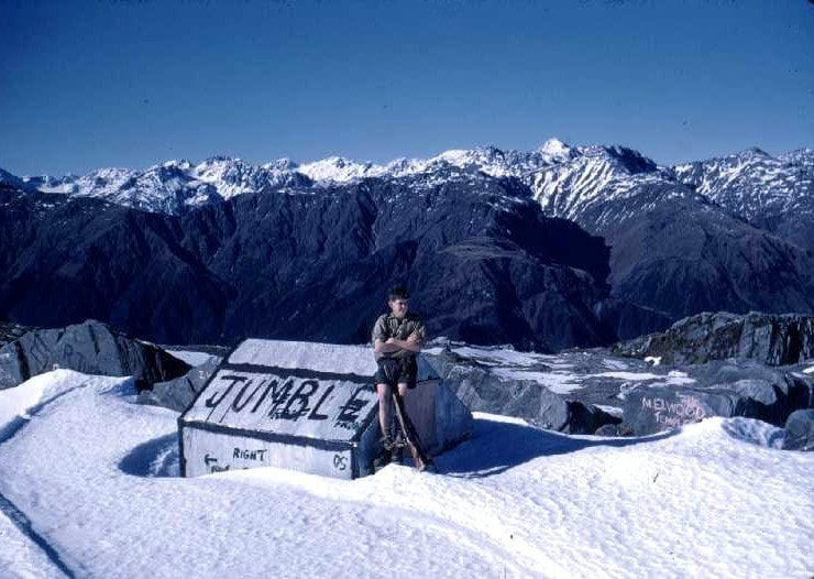 Jumbletop Biv: photo Ron Turner 1957
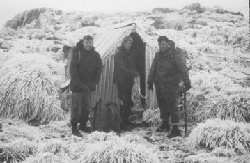
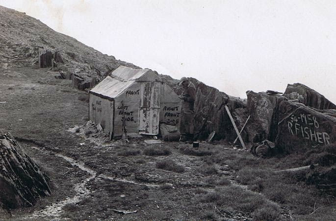
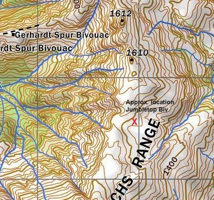
Jumble Top Biv
Jumble Top Biv was built in 1957 on a bench at 1500m, just below the crest of the Diedrichs Range between Jumble Top and Mt. O'Connor. It was a B49 structure with flat-iron walls and roof. The builders were P.R. (Jock) Fisher, Merv Ellwood, Ross Courtney, and Ron Turner of the NZFS. Unfortunately, the Biv's 2x2 rimu framing was no match for the snow loadings common at that altitude. In the photo below taken in 1958 the roof was already starting to cave in. The Biv was a flattened mass of iron by the time I first traversed Jumbletop in 1976. Ron Turner provided the early photos of the Biv and confessed to being embarrassed now about the graffiti on the rocks.
Jumble Top Biv was built in 1957 on a bench at 1500m, just below the crest of the Diedrichs Range between Jumble Top and Mt. O'Connor. It was a B49 structure with flat-iron walls and roof. The builders were P.R. (Jock) Fisher, Merv Ellwood, Ross Courtney, and Ron Turner of the NZFS. Unfortunately, the Biv's 2x2 rimu framing was no match for the snow loadings common at that altitude. In the photo below taken in 1958 the roof was already starting to cave in. The Biv was a flattened mass of iron by the time I first traversed Jumbletop in 1976. Ron Turner provided the early photos of the Biv and confessed to being embarrassed now about the graffiti on the rocks.
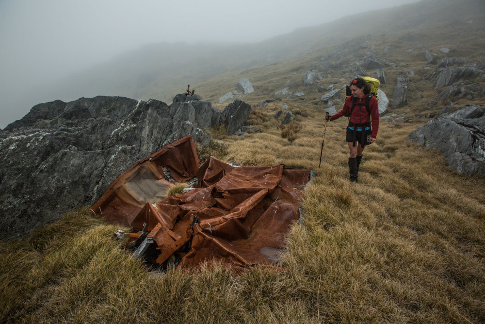
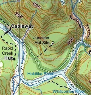
Junction Hut
Junction Hut was a S81 4-bunk design with open fire built in 1961 and sat on a terrace above the Hokitika-Whitcombe Junction. The Hut clearing was ringed by tall podocarp/ hardwood forest and it was a shady and damp site. There was a steep 10-15 minute climb up onto the terrace from the River which seemed to deter most of the passers-by on Whitcombe or Hokitka circuits, so Junction never got much use. It was only an hour from the roadend, and Rapid Creek Hut directly over the River was a better hunting option. The Whitcombe route was diverted across the river to Rapid Creek in 1975 after a big slip on the TR wiped out the Frews track, and the FS stopped maintaining the tracks in the Lower Hokitika about this time as well. From then on the Hut would have received very few visits. Junction Hut was probably removed by the NZFS sometime in the mid 1980's. Greg Ross recalls doing a hut check there in 1983 and says the Hut was still in good condition. |
Junction Hut: Photo Lance Barnard
|
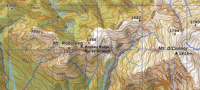
Knobby Ridge Biv
Knobby Ridge Biv was located on the Diedrichs Range on a flat area of Knobby Ridge just East of Mt. Robinson. There were stunning views from the Biv out over the Kowhiterangi Plain to the coast. Knobby Ridge was a B55 design with corrugated iron roof and a louvre window built by the NZFS in 1961. The access track up Knobby Ridge was a long grind with lots of ups and downs. A reasonable-sized tarn next to the Biv provided water. The access track was already fairly overgrown by the late 1970's when I last used it. Despite this Derek Hartley and Paul Pugh did a total NZFS re-vamp of the Biv in autumn 1984, and it still would have been in prime condition in the late 80's, when DOC in one of their inaner moves removed it for use as radio shack. It must have cost them a fair bit to fly it down. The Biv was recently rediscovered on a farm track beside the Punakaiki River a few minutes upstream from the car park at the end of Waikori Road. It had one mattress resting on the floor, a crude table inside, and it leaked. It was put there by DOC for some unknown reason many years ago and then abandoned. The landowner was happy to get rid of it and DOC had no further interest, so Neil Bradley of Hokitika took it back to his place where he intends repairing it and will possibly donate it back to Permolat.
Knobby Ridge Biv was located on the Diedrichs Range on a flat area of Knobby Ridge just East of Mt. Robinson. There were stunning views from the Biv out over the Kowhiterangi Plain to the coast. Knobby Ridge was a B55 design with corrugated iron roof and a louvre window built by the NZFS in 1961. The access track up Knobby Ridge was a long grind with lots of ups and downs. A reasonable-sized tarn next to the Biv provided water. The access track was already fairly overgrown by the late 1970's when I last used it. Despite this Derek Hartley and Paul Pugh did a total NZFS re-vamp of the Biv in autumn 1984, and it still would have been in prime condition in the late 80's, when DOC in one of their inaner moves removed it for use as radio shack. It must have cost them a fair bit to fly it down. The Biv was recently rediscovered on a farm track beside the Punakaiki River a few minutes upstream from the car park at the end of Waikori Road. It had one mattress resting on the floor, a crude table inside, and it leaked. It was put there by DOC for some unknown reason many years ago and then abandoned. The landowner was happy to get rid of it and DOC had no further interest, so Neil Bradley of Hokitika took it back to his place where he intends repairing it and will possibly donate it back to Permolat.


Knobby Ridge Hut
Knobby Ridge Hut was a standard S81 four-bunker located at the front of the Diedrichs Range on the TL terrace of Diedrichs Creek, between Diedrichs and Granite Creeks. It was a four-bunk S81 design with open fire accessible by vehicle. It burned down sometime in the mid-late 1970's. |

Knobby Ridge Hut; Photo Lance Barnard 1971
|

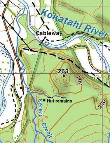
Lower Kokatahi Hut
Lower Kokatahi Hut, also called Whakarira Hut, was a four-bunk design with open fire, purportedly built in 1959. It was located downriver from Dismal Creek on the TR of the Kokatahi, at NZTM E1449821, N5248087. It was in rough condition and rat infested when Glenn Johnston last stayed there in 1972. He says it seemed older than a 1959 build and didn't have the appearance of the standard S81 design from that period. It wasn't stocked with the usual NZFS gear either. Perhaps the build date was confused with other Huts in the Kokatahi built around 1959, or it seemed older because of its poor condition. According to Greg Ross it was dismantled by NZFS in 1983 and the materials used to make outhouses and woodsheds for Poet, Frisco, Frew, Sir Robert, and other huts in the Hokitika and Mungo valleys. All that remains currently at the site is a small slab of concrete and some orange painted flat iron, most of it neatly stacked.
Lower Kokatahi Hut, also called Whakarira Hut, was a four-bunk design with open fire, purportedly built in 1959. It was located downriver from Dismal Creek on the TR of the Kokatahi, at NZTM E1449821, N5248087. It was in rough condition and rat infested when Glenn Johnston last stayed there in 1972. He says it seemed older than a 1959 build and didn't have the appearance of the standard S81 design from that period. It wasn't stocked with the usual NZFS gear either. Perhaps the build date was confused with other Huts in the Kokatahi built around 1959, or it seemed older because of its poor condition. According to Greg Ross it was dismantled by NZFS in 1983 and the materials used to make outhouses and woodsheds for Poet, Frisco, Frew, Sir Robert, and other huts in the Hokitika and Mungo valleys. All that remains currently at the site is a small slab of concrete and some orange painted flat iron, most of it neatly stacked.
Lower Styx
Lower Styx was a standard S81 four-bunk design with open fire, built in 1959. It was located on the River flat on the TL of the lower Styx. When John Bathgate visited in the early 1970's, it had been used regularly by a Government hunter and still had equipment and some food supplies. When I stopped there in the mid-70's the Hut was empty of provisions and starting to get a bit shabby. A bit of debris can still be found near the hut site.
Lower Styx was a standard S81 four-bunk design with open fire, built in 1959. It was located on the River flat on the TL of the lower Styx. When John Bathgate visited in the early 1970's, it had been used regularly by a Government hunter and still had equipment and some food supplies. When I stopped there in the mid-70's the Hut was empty of provisions and starting to get a bit shabby. A bit of debris can still be found near the hut site.
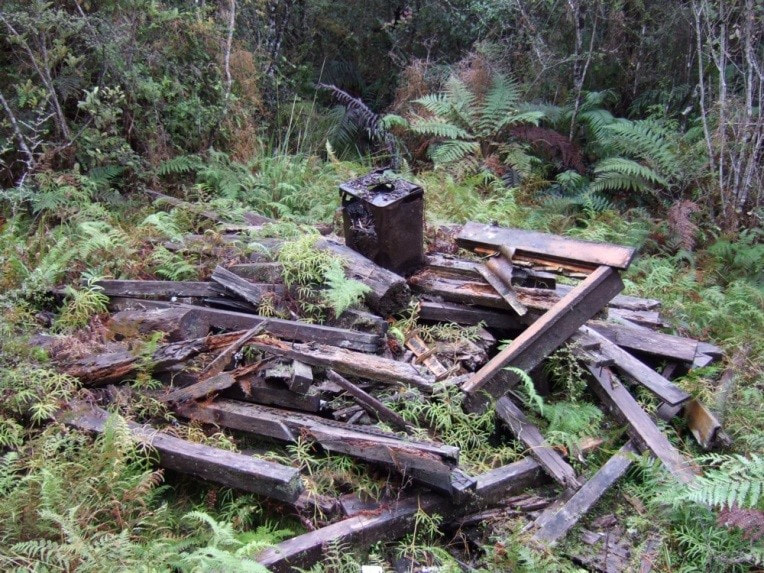 Lower Toaroha Hut remains: Photo Glenn Johnston 2014 Lower Toaroha Hut remains: Photo Glenn Johnston 2014
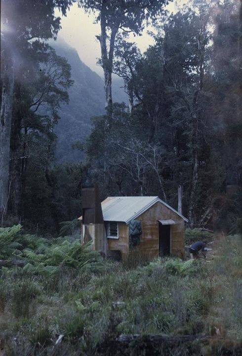
Lower Toaroha
Lower Toaroha or Kereru Creek Hut in the Lower Toaroha valley was built in 1961 and was probably a S81 four-bunk design with open fire. Glenn Johnston relocated the hut remains in 2014, East of Kereru Creek at NZTM2000: E1448131/ N5247615. The tongue and groove floor was still there, as was most of the framing and window frames. The faded orange paint was recognisable on some of the woodwork. The Hut was pulled down in the early 2000's according to Ted Brennan, ex-DOC, the flat-iron and roofing iron removed, and the woody bits left to rot. Prior to its dismantling it was in poor condition, with the flat-iron pretty much holding things together. The floor and piles were knackered, as was much of the framing. Part of the route to the site is via an old logging tram from part way up Kereru Creek. It's pretty close to a clearing with a deer pen. Sphagnum moss poachers also used to visit the area. An old logging tram leads fairly close to the Hut site and someone had been keeping the route to the deer pen in reasonable order back in 2014. |
|
Monro Mistake Hut
Paul Elwell-Sutton sent us a photo of this derelict hut at the confluence of the Whakapohai River and Monro Mistake Creek, near Haast, Westland. It was built as a base in the deer hunting days of the 60’s and/ or 70’s by Barry Wyber of the Whakapohai, and the late Bruce Sproull of Okuru. They took the materials in by Landrover and there is allegedly a stainless steel pot under the ruins. Its a delightful 2-3 hour walk in on a fine day with a low river. |
|
|
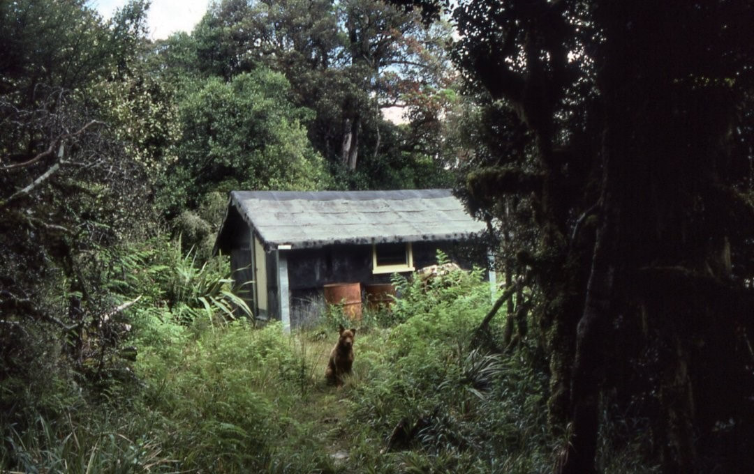 Old Mt Brown Hut: Photo John Hughes 1985 Old Mt Brown Hut: Photo John Hughes 1985
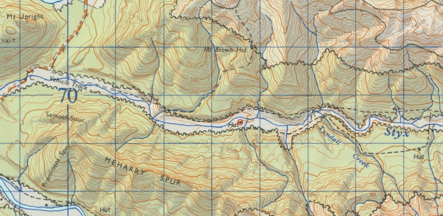
Old Mt Brown Hut
lThe old Mt Brown was located at 820m on a broad spur on the Styx valley side of Mt Brown. It was built in the 1970's, probably by Forest Research Institute, for opossum studies and is identical to two Huts built by Derrick Field for the NZFS in the North Island. The design was adopted from a hut built by opossum researcher Les Pracy in the Pararaki valley. The hut's exterior was malthoid, and the interior chicken wire over a precut timber frame. The Hut was in a small, clearing surrounded by forest and was quite dark and dingy. There was no heating, and water was from a 44-gallon drum set under the eaves. It had a standard NZFS kerosine cooker. Merv Nicolle visited the hut in the early 80's to fix the roof and instal a new water drum. He didn't see any ghosts despite stories of the Hut being haunted. Old Mt Brown was accessed from the Styx valley and the track is still used as a route to the new Mt. Brown Hut. The old hut was removed by DOC around 2006. |
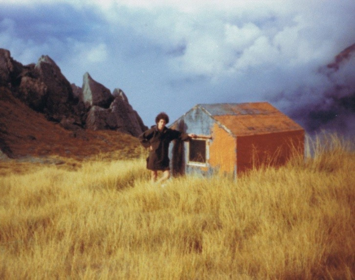
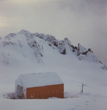
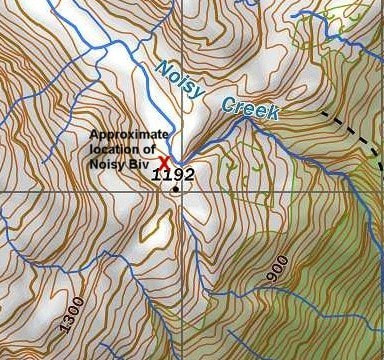
Noisy Biv
Noisy Biv was located on the TR of the Noisy Creek basin in the Whitcombe Valley. It was a B49 structure with flat iron walls and roof built in 1958. Noisy was a handy stopover on the route between Frew Hut and Cropp Basin Hut but wasn't maintained from the mid 1970's onward. It became increasingly dilapidated over the years and was eventually blown off its piles. Noisy Biv was removed by DOC in 2006 and some of its rafters and iron cladding were used to repair Whitehorn and Kokatahi Bivs which were rescued from the Hokitika Dump around the same time. The track up to Noisy Creek Basin was recently reinstated by DOC to fully maintain, however the old NZFS track from the Noisy Creek tops down into the Cropp basin hasn't been maintained for some decades and has gone completely in most places. Someone was sounding DOC out a while back about the possibility of constructing a high-stud Biv in Noisy Creek Basin near the old Biv site. It would be nice if that happened
Noisy Biv was located on the TR of the Noisy Creek basin in the Whitcombe Valley. It was a B49 structure with flat iron walls and roof built in 1958. Noisy was a handy stopover on the route between Frew Hut and Cropp Basin Hut but wasn't maintained from the mid 1970's onward. It became increasingly dilapidated over the years and was eventually blown off its piles. Noisy Biv was removed by DOC in 2006 and some of its rafters and iron cladding were used to repair Whitehorn and Kokatahi Bivs which were rescued from the Hokitika Dump around the same time. The track up to Noisy Creek Basin was recently reinstated by DOC to fully maintain, however the old NZFS track from the Noisy Creek tops down into the Cropp basin hasn't been maintained for some decades and has gone completely in most places. Someone was sounding DOC out a while back about the possibility of constructing a high-stud Biv in Noisy Creek Basin near the old Biv site. It would be nice if that happened
Pyramid Hut
Pyramid Hut was located on the TL in the head of the Arahura valley on the Browning Pass (Noti Raukeka) bridle track (NZTM E1464343/ N524582). The West Coast Times in 1906 reports the Westland County Council being lobbied to build a hut near the foot of the Browning Pass at the “Pyramids.” An NZFS report from 1981 states that the hut was built about 1908 by Ern and George Pfahlert and Bert Fiddes, probably with financial help from the Council. It was constructed for use by gold miners, prospectors and the packers supplying them. George and Bert have gold bearing reefs named after them in the head of the Wilberforce. Supplies were packed in from the West Coast for mining and prospecting these reefs. Pyramid Hut was sited on a levelled bench supported at the front by a wall of stacked rocks. It had low rock walls around the exterior up to below window level. The roof was corrugated iron and the interior framing was hewn native timber. Trampers began using the Hut after the mining activity ceased and an article from 1921 names the Hut as one of the shelters on the Pass route, describing it as a "capacious hut." It was probably abandoned around 1963 when the NZFS built Harman Hut 1.6kms downriver. The Hut was still standing in the early 1970's, but derelict by then, with large holes in the corrugated iron roof. In 1973 the track was redirected from the original benchline down to the riverbed and Pyramid Hut was no longer passed by trampers. By 2015 all that could be found at the hut site was rusted iron, the toppled remains of the rock work, and the contents of a rubbish hole.
Pyramid Hut was located on the TL in the head of the Arahura valley on the Browning Pass (Noti Raukeka) bridle track (NZTM E1464343/ N524582). The West Coast Times in 1906 reports the Westland County Council being lobbied to build a hut near the foot of the Browning Pass at the “Pyramids.” An NZFS report from 1981 states that the hut was built about 1908 by Ern and George Pfahlert and Bert Fiddes, probably with financial help from the Council. It was constructed for use by gold miners, prospectors and the packers supplying them. George and Bert have gold bearing reefs named after them in the head of the Wilberforce. Supplies were packed in from the West Coast for mining and prospecting these reefs. Pyramid Hut was sited on a levelled bench supported at the front by a wall of stacked rocks. It had low rock walls around the exterior up to below window level. The roof was corrugated iron and the interior framing was hewn native timber. Trampers began using the Hut after the mining activity ceased and an article from 1921 names the Hut as one of the shelters on the Pass route, describing it as a "capacious hut." It was probably abandoned around 1963 when the NZFS built Harman Hut 1.6kms downriver. The Hut was still standing in the early 1970's, but derelict by then, with large holes in the corrugated iron roof. In 1973 the track was redirected from the original benchline down to the riverbed and Pyramid Hut was no longer passed by trampers. By 2015 all that could be found at the hut site was rusted iron, the toppled remains of the rock work, and the contents of a rubbish hole.

Rapid Creek Biv
Rapid Creek Biv had a brief existence in the head of Rapid Creek in the Hokitika valley. It was one of the last of the new generation high-stud B149 designs built in 1974 by the NZFS. Rapid Creek Biv was lined, had two bunks, and two louvre windows. It was very cosy and the views were stunning, but visits were few and far between. Access to the Biv was up the Miserable Ridge tops track from Rapid Creek to around 800m, then down a steep gut into Rapid Creek. The Creek was followed up into the headwaters from where a steep ridge climb led up to the Biv. Rapid Creek Biv was still in mint condition in the late 1980's when DOC decided to remove it, at some expense no doubt, to be used as a radio shack. It's current location, if there is one, is unknown
Rapid Creek Biv had a brief existence in the head of Rapid Creek in the Hokitika valley. It was one of the last of the new generation high-stud B149 designs built in 1974 by the NZFS. Rapid Creek Biv was lined, had two bunks, and two louvre windows. It was very cosy and the views were stunning, but visits were few and far between. Access to the Biv was up the Miserable Ridge tops track from Rapid Creek to around 800m, then down a steep gut into Rapid Creek. The Creek was followed up into the headwaters from where a steep ridge climb led up to the Biv. Rapid Creek Biv was still in mint condition in the late 1980's when DOC decided to remove it, at some expense no doubt, to be used as a radio shack. It's current location, if there is one, is unknown
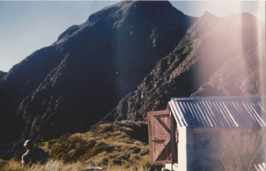
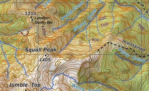
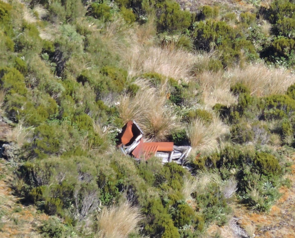
Secretary Ridge Biv
Secretary Ridge Biv, also called Sentry Biv was located on point 1210m on Secretary Ridge, high on the TL of the Toaroha valley
at the Northern end of the Diedrichs Range. Visitors were probably deterred by the steep, narrow and scrubby ridge that provided the only access down to it from Squall Peak. It was a NZFS B55 design built in 1961, and was already dilapidated by the mid 1970's when I visited. The door was off, a sheet of iron missing from the roof, and rusting cans, utensils, and spent 303 cartridges littered the ground around it. The climb back up onto Squall Peak through the scrub removed any incentive for future visits. The Biv gradually collapsed into a heap over the years and its remnants are still visible with the right magnification from Squall Peak.
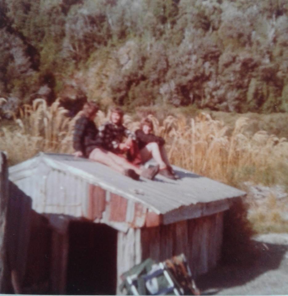
Singers Hut
The remains of Singers Hut are located in the lower Arahura valley a few metres off the track in some low hardwood scrub about 40 minutes up from the Cesspool (E1457997/ N5253605). The old timers called it Bark Hut and the younger ones, Singers Hut. In 1956 Ab Singer pulled down the old Bark Hut which was up river at the 40 Acres and used the material to build Bark Hut No. 2, aka Singers. Richard Herring says Ab split the totara for the walls which he covered with old corrugated iron. The new roof was aluminium. Ab was working on the Arahura gold dredge around the time he built the Hut. He also worked for Westland Greenstone and lived with his family in the Arahura valley prior to moving to Kaihinu. Ab used the Hut as a base for possuming. His three boys and their friends used it as a hunting base during the 1960’s. Later in the decade it was engulfed by a slip which left it about two thirds buried. Nowadays it's still there with just the roof sticking up.
The remains of Singers Hut are located in the lower Arahura valley a few metres off the track in some low hardwood scrub about 40 minutes up from the Cesspool (E1457997/ N5253605). The old timers called it Bark Hut and the younger ones, Singers Hut. In 1956 Ab Singer pulled down the old Bark Hut which was up river at the 40 Acres and used the material to build Bark Hut No. 2, aka Singers. Richard Herring says Ab split the totara for the walls which he covered with old corrugated iron. The new roof was aluminium. Ab was working on the Arahura gold dredge around the time he built the Hut. He also worked for Westland Greenstone and lived with his family in the Arahura valley prior to moving to Kaihinu. Ab used the Hut as a base for possuming. His three boys and their friends used it as a hunting base during the 1960’s. Later in the decade it was engulfed by a slip which left it about two thirds buried. Nowadays it's still there with just the roof sticking up.
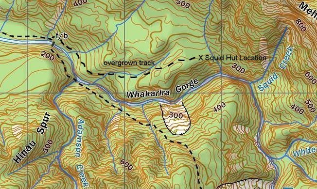
Squid Hut
Squid Hut was an S81 4-bunk design with open fire built in 1959. It was located on the TR of the Kokatahi River above the Whakarira Gorge. The NZFS ceased maintaining the tracks on the TR of the Kokatahi sometime in the 1970's and they rapidly reverted back to bush. As a result, folk stopped using that side of the valley. A local possumer lived there for a time in the early 1990's. Squid Hut was designated for removal in DOC's 2003/ 4 Review but was deemed salvable by the Permolat Group. Its floor and chimney were
rotting, but the upper frame was dry and in good shape. There was little sign of recent visitation when we visited in 2005. but by that time, we needed GPS to locate it. Permolat was about to sign a maintain-by-community contract with DOC in 2008, when Squid burned down. It had been getting a few more visits since we'd trimmed and marked the access track, and someone had probably left a fire going in the dilapidated fireplace.

 Styx Saddle Hut: Photo Glenn Johnston 1976 Styx Saddle Hut: Photo Glenn Johnston 1976
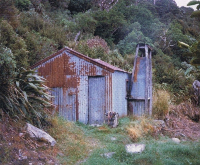
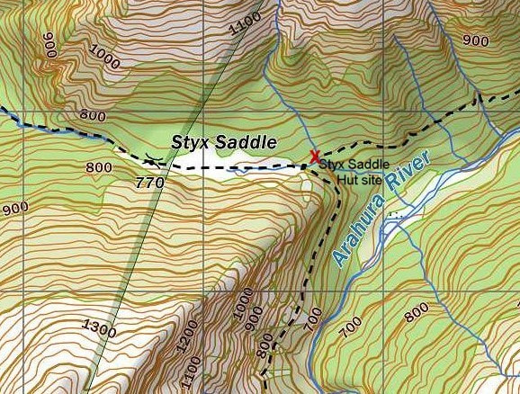
Styx Saddle Hut
Styx Saddle Hut was located in the Arahura valley a short distance down from Styx Saddle on the Browning Pass (Noti Ruareka) track. It is marked on a map published in June 1906. Several entries in the West Coast Times suggest the Hut was built by Westland County Council in 1905, although construction was being promoted in 1904 and earlier. It was in fairly constant use by 1906. It was still in relatively good condition in the early 1970's when I first visited it. The frame was sawn or adzed from timber growing near the site, and the cladding was corrugated iron. Bunks were of sacking and the beams and studs were a trove of local names carved, or written in charcoal, including that of Stan Graham of "Bad Blood" fame. The Hut was demolished several decades back, but the site is still clearly visible next to the bench track 10 minute down from the Styx Saddle turnoff. |
|
 Twins Hut; Photo Lance Barnard 1971 Twins Hut; Photo Lance Barnard 1971
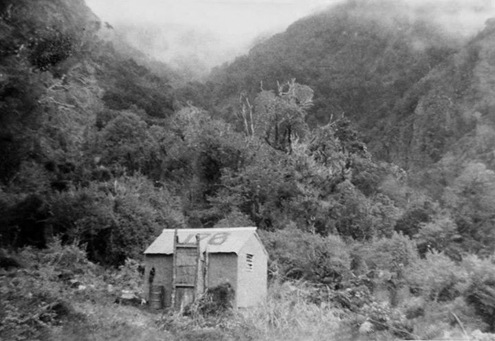
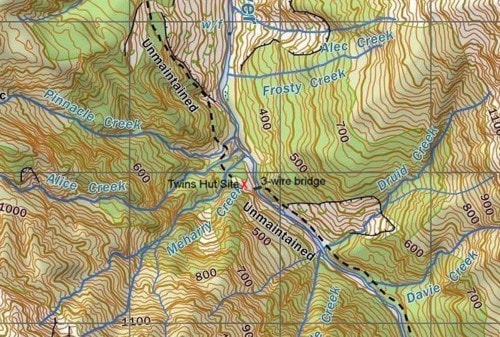
Twins Hut
Twins Hut was a standard S81 four-bunk design with open fire, built by the NZFS in 1962. It was located on a terrace on the TL of the Kokatahi River just upstream from Meharry Creek. It wasn't maintained from when Lands & Survey took over tenure of the valley in the 70's and 80's and became run down and dingy. It was removed fairly early in DOC's tenure, flow down, and dumped in a paddock not far from the Kokatahi roadend. Its dilapidated frame was visible for a while from the farm track, but has since vanished from view. The concrete chimney base is still somewhere in the overgrowing clearing where the Hut used to be and a bit of historical rubbish scattered here and there. |
|
 Twister Biv: Photo David Ramm 2008 Twister Biv: Photo David Ramm 2008
Twister Biv
Twister Biv located on the TR of The Twister, about an hour's walk up the Whataroa River from the Perth junction. It was built by Graeme 'Weka' Peat of Okarito in 1967 and used for goldmining and possum hunting. Bruce Reay visited it in 1975 and remembers a very good hut with a wetback. In 1978 a flood took it out and Graeme or others built a rough shelter out of the remains that had a wraparound iron cladding roof and wall, and an open fire with a wood frame chimney. It had no windows and was dank, dark and dingy inside and became increasingly dilapidated over time. It was designated for removal in DOC's 2003 review but was still standing in 2008 when David Ramm photographed it. Although it was in a bad way, he and a mate slept in it to get out of the rain. David says it was still being used then by others even though it was open to the weather on one side. The Twister has since blown out and where the Biv once stood is now covered in millions of tons of gravel. |

|

Vine Creek Hut
Vine Creek Hut was located on the TR of Vine Creek on the frontal terraces of the Diedrichs Range. Warren Godfrey has seen photos what he thinks may have been an Internal Affairs cullers hut at the site that would predate the building of an NZFS four-bunker there in 1961. As this was one of the first deer liberation areas it is quite possible. Robyn Neill was involved in pulling down the hut in the early 1980's. He said that by then it was sitting on the edge of farmland. Glenn Johnston had a look around where the hut was shown to be on the 1970 topo maps, but the bush and cutover from that era had been cleared for farming.
Vine Creek Hut was located on the TR of Vine Creek on the frontal terraces of the Diedrichs Range. Warren Godfrey has seen photos what he thinks may have been an Internal Affairs cullers hut at the site that would predate the building of an NZFS four-bunker there in 1961. As this was one of the first deer liberation areas it is quite possible. Robyn Neill was involved in pulling down the hut in the early 1980's. He said that by then it was sitting on the edge of farmland. Glenn Johnston had a look around where the hut was shown to be on the 1970 topo maps, but the bush and cutover from that era had been cleared for farming.
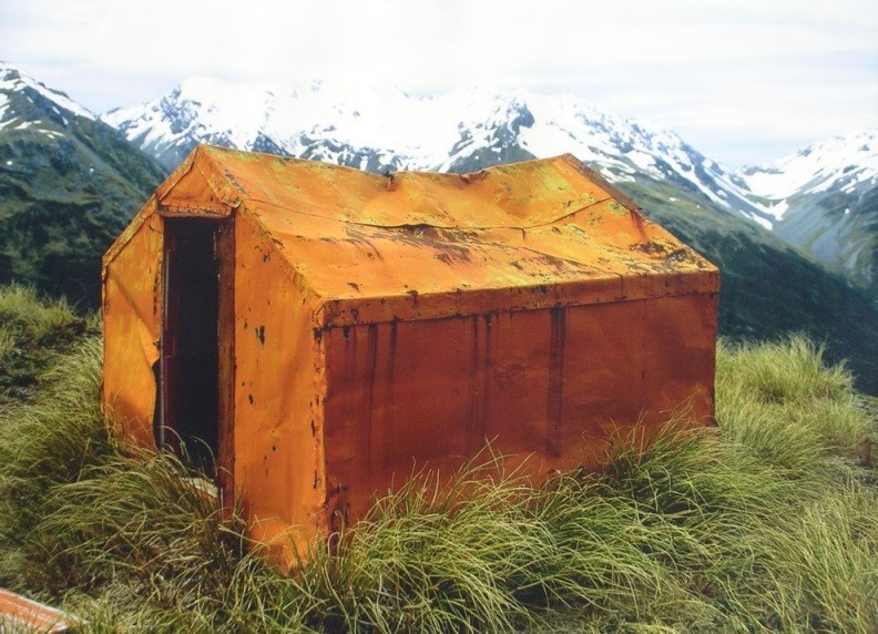
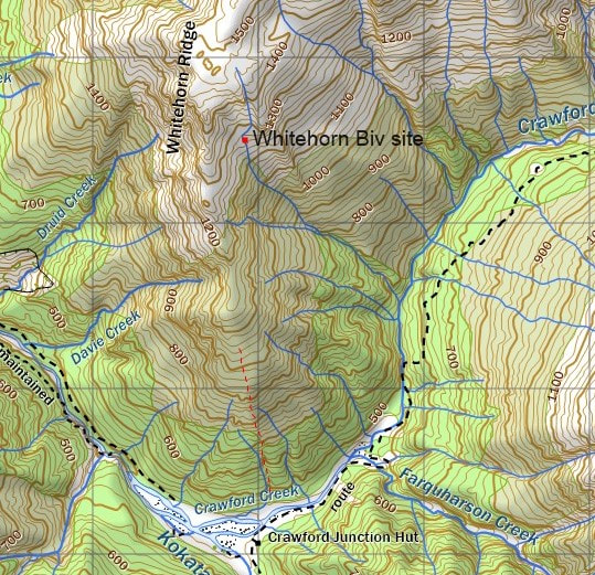
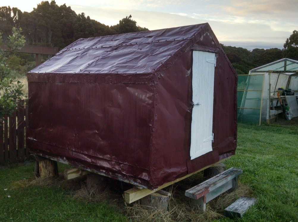
Whitehorn Spur Biv
Whitehorn Spur Biv was located at around 1260m on Whitehorn Spur at the Southern end of the Browning Range. It was a B49 design with flat iron walls and roof built by the NZFS in 1958. A track up from Crawford Junction provided access and the Browning Range could be traversed from the Biv. A pencil inscription on the door stud reads, "maintenance and painting carried out 19/9/71 - TN & PM." TN will be Tony Newton - don't know who PM is. Whitehorn was retrofitted by NZFS with bunks and a bench around 1974, but after this was not maintained and was very rarely visited. The Biv developed a serious roof leak sometime in the 1970's and the roof caved in at some point, possibly due to snow pressure. The door came off later down the track by which stage the structure was pretty much uninhabitable. Whitehorn was removed by DOC in 2006 and dropped at the Hokitika Dump. I salvaged and repaired it, and it is now in my back yard in Ruatapu awaiting repatriation.
Whitehorn Spur Biv was located at around 1260m on Whitehorn Spur at the Southern end of the Browning Range. It was a B49 design with flat iron walls and roof built by the NZFS in 1958. A track up from Crawford Junction provided access and the Browning Range could be traversed from the Biv. A pencil inscription on the door stud reads, "maintenance and painting carried out 19/9/71 - TN & PM." TN will be Tony Newton - don't know who PM is. Whitehorn was retrofitted by NZFS with bunks and a bench around 1974, but after this was not maintained and was very rarely visited. The Biv developed a serious roof leak sometime in the 1970's and the roof caved in at some point, possibly due to snow pressure. The door came off later down the track by which stage the structure was pretty much uninhabitable. Whitehorn was removed by DOC in 2006 and dropped at the Hokitika Dump. I salvaged and repaired it, and it is now in my back yard in Ruatapu awaiting repatriation.
 Crossing the Kokatahi before the Twins Swingbridge went in. Crossing the Kokatahi before the Twins Swingbridge went in.
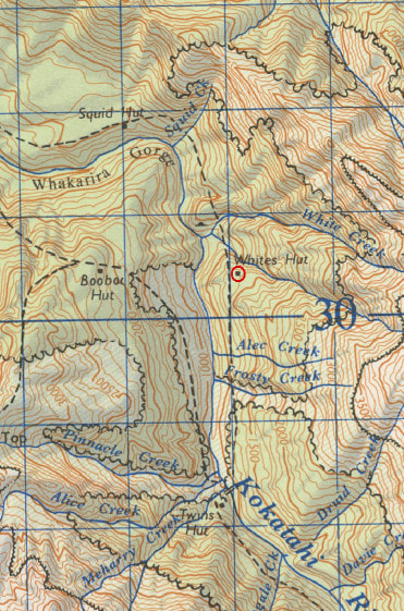
Whites Hut
Whites Hut was an NZFS, S81 four-bunk design with open fire located on the TR of the Kokatahi on a terrace above the TL branch of Whites Creek (E145376/ N524623). It was built in the late 1950's and was rarely visited after the TR tracks were abandoned by NZFS in the early 1970's. John Bathgate, an NZFS deer culler, recalls the deer being concentrated in the regrowth on the slip faces of the gorge. A hunter unfortunate enough to be assigned the valley would do the Squids, Whites, Twins, Boo Boo circuit, deviating to Junction Base for radio schedules. Whites and Twins huts were well-used in the 1969-70 hunting seasons, with an improvised rope to aid crossing the gorge between them." When a DOC party visited Whites in 1996, the track was long gone, and the Hut had to be accessed from the Kokatahi riverbed. It was surrounded by dense hardwood regrowth, and while still intact and upright, the entire frame and floor were rotten, and the floorboards caved in under the weight of the visitors' feet. Whites was removed by the Department in 2006. |
|
 Wren Creek Hut: Photo Ted Smith 1961 Wren Creek Hut: Photo Ted Smith 1961
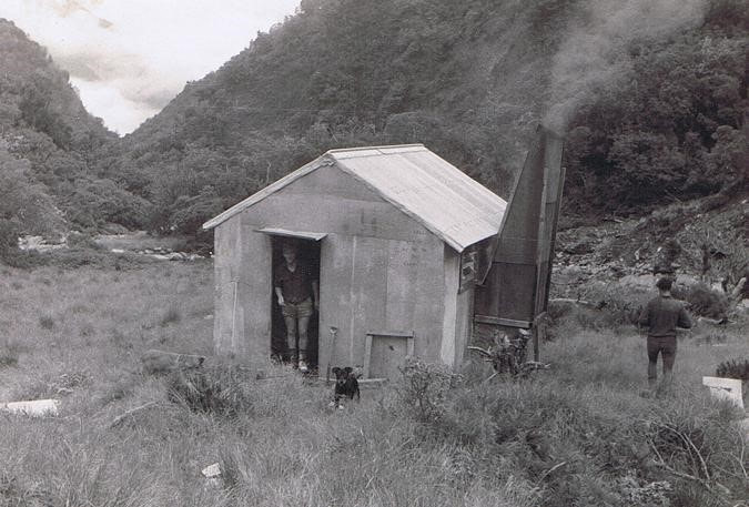
Wren Creek Hut
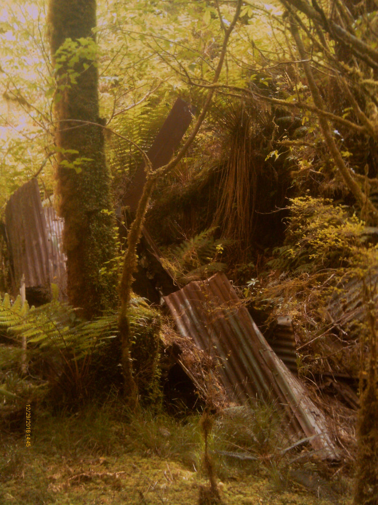
Wren Creek Hut was a S81 four-bunk design with open fire built by the NZFS in the late 1950's. It was located Wren Creek Basin in the Toaroha valley. Below the basin the Creek drops steeply through down a series of waterfalls to the Toaroha. Access to Wren Creek basin was up a ridge track on the TR of Wren Creek that continues up to Allan Knob. A side-track drops from a knoll in the sub-alpine zone (5242381N 1449452E) down into the basin. John Bathgate who worked for NZFS in the area from 1969-72 says that the Hut was knocked off its piles by the Creek in 1966, and not restocked from then on. By 1969 the few remaining supplies, even the canned spaghetti, was semi-mummified. The floor was holed by stream debris around the food cupboard and possums appreciated the convenient access. The whole structure had a list. By 1986 the front end of the Hut had collapsed although the rear was still intact and upright and the bunks dry when I spent a night there. The track to Allan Knob was still OK at the time, but the side-track into the basin was already hideously overgrown and difficult to follow. The Allan Knob track was recut by Andrew Friedman in 2018 and the side-track down into the basin by Indy Hawthorn and Sam Holt in 2024. All that remained of the Hut at the original site was a sheet of half buried iron. They found more bits and pieces further up the basin, possibly salvaged bits that someone had attempted to make another shelter out of. |
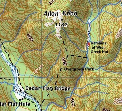

The Hut site now
|
