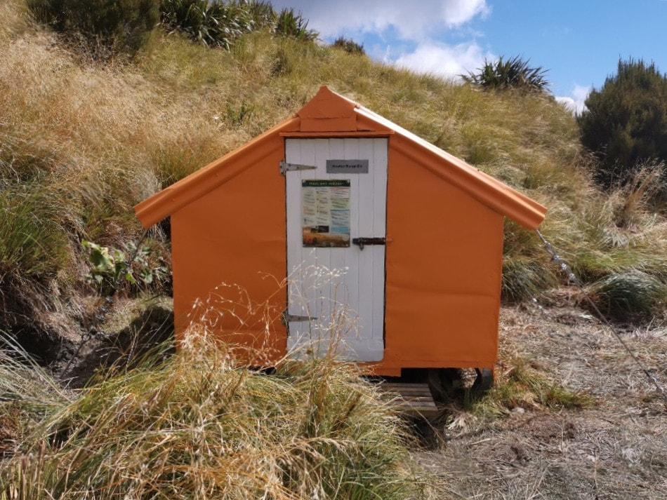
Newton Range Biv

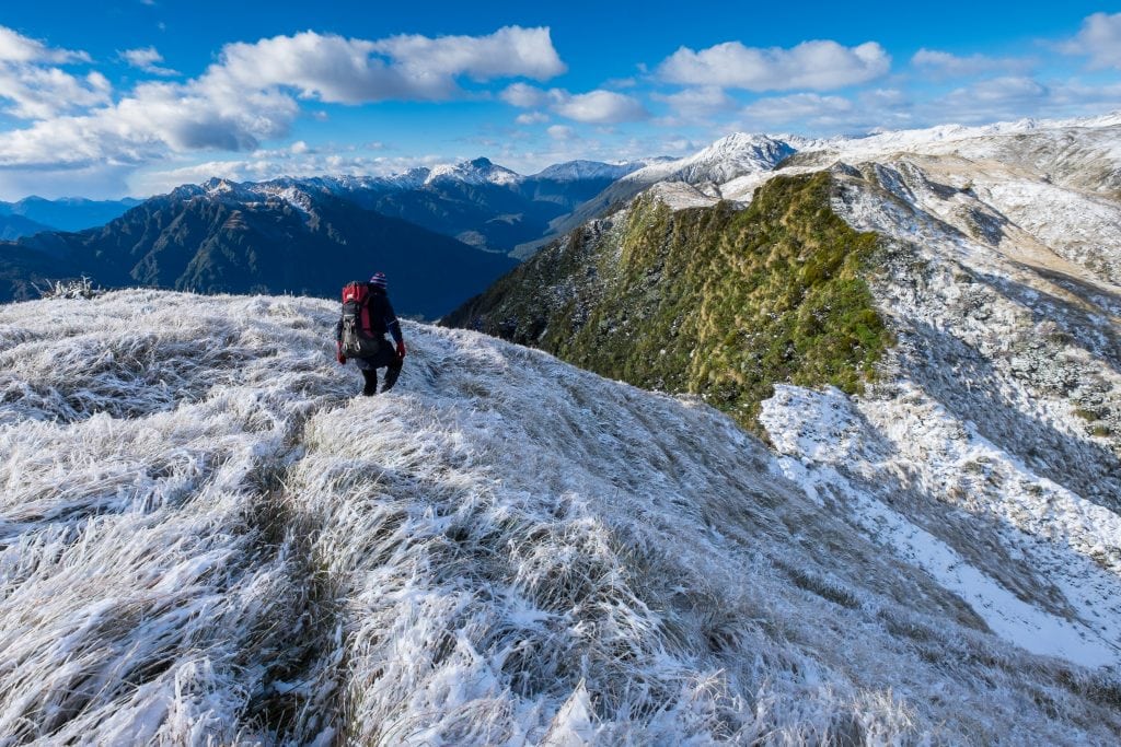
 View over to the Browning Range from near Newton Biv
Maintenance Status
When Newton Range Biv was designated as minimal maintenance by the Department of Conservation in 2003, it hadn't had any work done on it since the 1970's and was getting pretty run-down. DOC did some one-off work in 2004, but it wasn't enough to prevent moisture getting in. Permolat got interested in 2016 and Group member Bruce McClelland, an ex-New Zealand Forest Service culler, and Chris Matheson of Ashburton, carried out some repairs on it. The remaining work was carried out by Bruce and others in February 2023. BCT and Permolat went 50/50 for the funding for this last phase.
Newton Biv became isolated and difficult to get to after the NZFS access track from the Styx valley vanished back into the scrub. For around 30 years visits to it were few and far between, despite its relative closeness to the Styx roadend. Permolat has recut and marked the old track from the Styx, along with another from the Lower Arahura valley that provides access further along the Newton Range.
Location
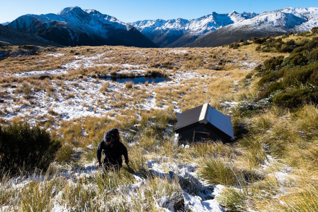
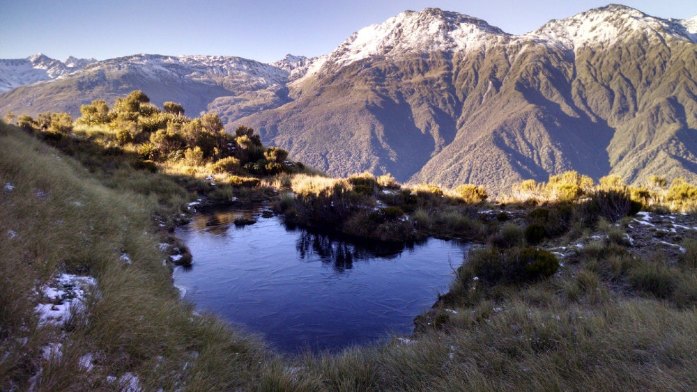
Newton Biv is located on the crest of Newton Range between the Arahura and Styx catchments. Map BV19. Altitude 1155m. GPS Ref: E1458873/ N5251148 (BV19 589 511). It is sits hard up against a tussock slope at the edge of a large flat peaty area and has beautiful panoramic views of the Alps and coastal plains. The setting is serene and tranquil and there are numerous small, deep tarns and peat subsidences in the vicinity. Newton Biv is accessible in a day from the Styx roadend and visits have gone from one every 2-3 years to around 10 per year since it was profiled on the site and the track recut. There is also the odd fly-in hunting party. Deer are quite plentiful on the tops in this area currently.
Access
The route to Newton Biv starts from the Grassy Flats track in the Styx valley. The Styx valley route has suffered greatly from a series of extreme weather events in recent times and the old Browning Pass bench track on the TR has been taken out in a number of places. DOC is advising trampers to go via the Mid Styx Hut route on the TL, adding a good hour to the trip. It is still possible to go all the way up the TL using the old, benched track where possible or boulderhopping where it has been washed away. A fairly gnarly bush bash over some bluffs is necessary just above Tyndall Creek where the river has cut right in. Above this the track remnants or riverbed are pretty good travel, with more of the old bench intact as you get further up the valley.
When coming up the TL the Mid Styx detour can be avoided at low river levels by crossing back to the TR above Tyndall Creek and continuing up the original trackline where it isn't washed out. The best ford currently is around 200m upstream from Tyndall Creek (E1455138/ N5249878). This ford should definitely not be attempted if the river is running above normal levels. If this one isn't any good you may have to boulderhop upriver and find a place where it flattens and widens. For those using the Mid Styx route, the ford back to the TR is also prone to change. It is currently OK just below where the track drops back to the river. If not, you'll need to boulderhop upriver to find a better crossing. Don't attempt any of the crossings if the river is up.
The Newton Biv route starts 100m up the TR of the large unnamed side-creek situated 1/2 an hour below Grassy Flat Hut (E1458968/ N5249853). The turnoff and entrance are marked with routered signs. The track goes directly up the ridge on the TR of the creek to around 960m, then sidles East across some eroding faces in the creek's head. It rejoins the ridge for the last short steep bit up through the alpine scrub. Once in the tussock, the route climb/ sidles in a NE direction onto the crest of the Range. It's an easy amble eastward from here to where the Biv is tucked in against the bank at the western edge of a large flat peaty area. Snow stakes lead from the ridge crest over to where the Biv is sited. Michal Klajban and Jan Kupka did some work on the track in July '24, trimming, marking and removing windfall. The track is OK but could do with a bit more tidying. Allow 6-7 hours currently to reach Newton Biv from the Styx roadend.
When Newton Range Biv was designated as minimal maintenance by the Department of Conservation in 2003, it hadn't had any work done on it since the 1970's and was getting pretty run-down. DOC did some one-off work in 2004, but it wasn't enough to prevent moisture getting in. Permolat got interested in 2016 and Group member Bruce McClelland, an ex-New Zealand Forest Service culler, and Chris Matheson of Ashburton, carried out some repairs on it. The remaining work was carried out by Bruce and others in February 2023. BCT and Permolat went 50/50 for the funding for this last phase.
Newton Biv became isolated and difficult to get to after the NZFS access track from the Styx valley vanished back into the scrub. For around 30 years visits to it were few and far between, despite its relative closeness to the Styx roadend. Permolat has recut and marked the old track from the Styx, along with another from the Lower Arahura valley that provides access further along the Newton Range.
Location
Newton Biv is located on the crest of Newton Range between the Arahura and Styx catchments. Map BV19. Altitude 1155m. GPS Ref: E1458873/ N5251148 (BV19 589 511). It is sits hard up against a tussock slope at the edge of a large flat peaty area and has beautiful panoramic views of the Alps and coastal plains. The setting is serene and tranquil and there are numerous small, deep tarns and peat subsidences in the vicinity. Newton Biv is accessible in a day from the Styx roadend and visits have gone from one every 2-3 years to around 10 per year since it was profiled on the site and the track recut. There is also the odd fly-in hunting party. Deer are quite plentiful on the tops in this area currently.
Access
The route to Newton Biv starts from the Grassy Flats track in the Styx valley. The Styx valley route has suffered greatly from a series of extreme weather events in recent times and the old Browning Pass bench track on the TR has been taken out in a number of places. DOC is advising trampers to go via the Mid Styx Hut route on the TL, adding a good hour to the trip. It is still possible to go all the way up the TL using the old, benched track where possible or boulderhopping where it has been washed away. A fairly gnarly bush bash over some bluffs is necessary just above Tyndall Creek where the river has cut right in. Above this the track remnants or riverbed are pretty good travel, with more of the old bench intact as you get further up the valley.
When coming up the TL the Mid Styx detour can be avoided at low river levels by crossing back to the TR above Tyndall Creek and continuing up the original trackline where it isn't washed out. The best ford currently is around 200m upstream from Tyndall Creek (E1455138/ N5249878). This ford should definitely not be attempted if the river is running above normal levels. If this one isn't any good you may have to boulderhop upriver and find a place where it flattens and widens. For those using the Mid Styx route, the ford back to the TR is also prone to change. It is currently OK just below where the track drops back to the river. If not, you'll need to boulderhop upriver to find a better crossing. Don't attempt any of the crossings if the river is up.
The Newton Biv route starts 100m up the TR of the large unnamed side-creek situated 1/2 an hour below Grassy Flat Hut (E1458968/ N5249853). The turnoff and entrance are marked with routered signs. The track goes directly up the ridge on the TR of the creek to around 960m, then sidles East across some eroding faces in the creek's head. It rejoins the ridge for the last short steep bit up through the alpine scrub. Once in the tussock, the route climb/ sidles in a NE direction onto the crest of the Range. It's an easy amble eastward from here to where the Biv is tucked in against the bank at the western edge of a large flat peaty area. Snow stakes lead from the ridge crest over to where the Biv is sited. Michal Klajban and Jan Kupka did some work on the track in July '24, trimming, marking and removing windfall. The track is OK but could do with a bit more tidying. Allow 6-7 hours currently to reach Newton Biv from the Styx roadend.
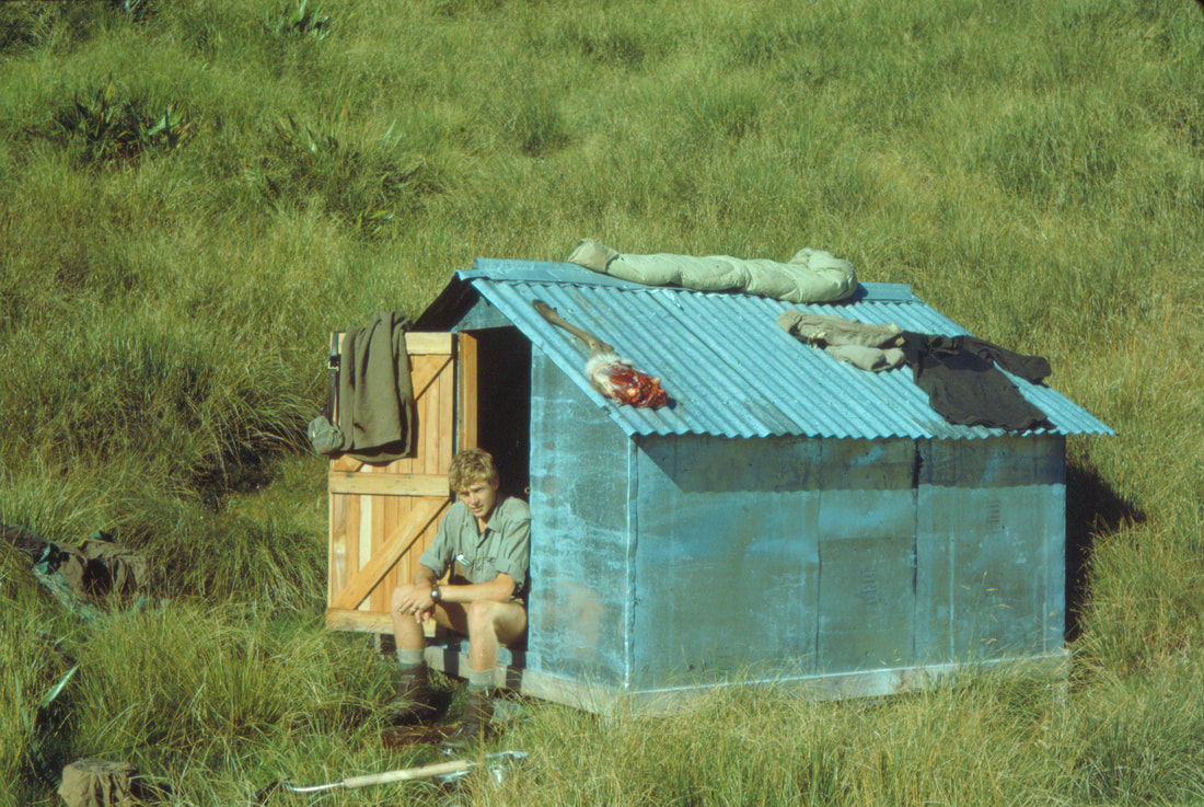 Newton Biv just after it was built - Photo Dave Richardson
Type
Newton Biv is a standard NZFS B55 two-person design built in 1962. It had a corrugated iron roof, a single louvre window at the back end, two narrow wooden sleeping benches, and a low cooking bench. Use the tarn closest to the Biv for water and the more distant ones for washing or swimming. There is no toilet so please don't crap around the Biv as the water table is high and waste could seep into the tarn used for drinking.
Condition
The Biv was re-piled and had its bearers, and some of the joists, framing, and floor replaced by DOC in 2004. It was re-roofed by Bruce and Chris in March 2016 with the addition an inner layer of chicken wire and roofing wrap to improve weatherproofing. In February 23 Bruce flew in with Dell Phillips (Ashburton), Graham Russell, a retired Ashburton builder, and Marty Bisdee, the BCT carpenter, to complete the upgrade. The louvre window was replaced with a single pane double glazed one provided by DOC Hokitika, the lead flashing on the ridging was replaced with a non-toxic one, and some rotten sections of the door frame were replaced. Tiedowns provided by DOC were installed, and the Biv's exterior walls and window frames were painted. Some of the snow stakes that were flown up in 2016 were used to make a doorstep. The Biv has one standard sized DOC mattress which is a bit too big for either of the sleeping platforms. The door has warped unfortunately and there's a 1-2-inch gap at the bottom of the non-hinging side of the door. It's still mostly weather tight, but the gap's big enough to let mice in and there's a lot of droppings inside. The bottom of the NW corner stud has rotted out along with a small section of floor plate.
Routes
The Newton Range is traversable along its length but dips into the alpine scrub zone at a couple of points both East and West of the Biv, and travel is rough in these places. East of point 1190m there are several ups and downs through the alpine scrub before the Range rises back above the tussock line. A rough trail leads through the scrubby parts. There is a small cirque with two tarns and some good campsites at Pt. 1264 and it is open and relatively easy travel along the remainder of the Range to Mt Newton.
Access down to Lower Arahura Hut is possible using an old NZFS track opened up by Permolat volunteers in 2013. The route was re-trimmed to 600m by Andre Winkelman in February 2020. Flax has started crowding the track in the alpine scrub zone. Nina Dickerhof and James Thornton gave this section a light trim in 2022. There is a stake with permolat on the crest of the Range just above the big tarns and below this on the Arahura side is a cairn at E1461437/ N5251992 (BV19 614 520). More stakes lead down a steep face with patchy scrub to the top entrance of the track, which drops down a scrub face onto a narrow rib, then across and down some bluffy bush faces in the montane zone and onto a more defined ridge. The track follows this down to the Arahura valley intersecting the main valley track 200m downriver from Lower Arahura Hut. This route is very steep in places and the top section of track is incorrectly marked on the topo map. The actual trackline veers SW at the 720m contour instead of continuing straight up as marked and connects with the crest of the Range midway between Pts. 1264 and 1392m. Allow four hours from Newton Biv to Lower Arahura Hut, or 5-6 if coming from the opposite direction.
It is possible to access Mudflats Hut from Newton Biv over the top of Mt Newton and down Visitors Creek. There are some nice tarns and camping spots in the top basin of Visitors Creek, but below this the Creek drops over a waterfall and down through a slotted gorge. The fall can be skirted on the TL lip of the basin down the TL of a steep gut with a small waterfall near its top. The gut enters the main Creek at the bottom of the gorge. Below this the going is steep, rough and slippery, the middle of the Creek needs wading in places. There may be easier routes off Mt Newton using one of the side creeks upstream from Mudflats, but these still need checking out. Allow 6-8 hours for the journey from Newton Biv to Mudflats Hut.
There is also access off the SW ridge of Mt Newton onto Styx Saddle. The route down is via some well-used deer trails through a narrow band of scrub onto an open slip that takes you down onto the Browning Pass track.
 Newton Range heading East to Pt. 1336m: Photo Jo Stilwell 2018
The Newton Range is West of the Biv has been traversed more regularly since Mt Brown Hut was built. There is a rough unmarked trail through alpine scrub sections of the route which has numerous ups and downs but is well worth it in terms of the views it provides. From the Biv along to point 1240m is relatively easy. After this the Range dips steeply down through a band of scrub, then climbs up onto point 1330m, passing some interesting ultramafic rock outcrops on the way. There are some nice tarns just West of point 1330m. After 1240m the Range drops steeply into the alpine scrub zone, and even with the trail, the going is rough. The open tussock is not reached again until the 1140m mark on Mt Brown's eastern ridge. People are taking on average 7-10 hours to do this traverse according to the Biv's hutbook. Michal Klajban and Jan Kupka gave the scrub sections a reasonably good trim in July '24.
Repairs Needed.
Some door repairs to address the warping issue. The corner stud and rotten section of floor plate need replacing. Some more poles to mark the route from the scrubline to the crest of the Range on both access tracks would be useful. Both tracks are due for a recut if anyone's interested.
Provisions on site
The ubiquitous DOC hand shovel and brush, one small frypan, a shovel, and a small saw. There is some leftover flashing, screws, and framing material under the hut.
