Lower Olderog Biv
Maintenance Status
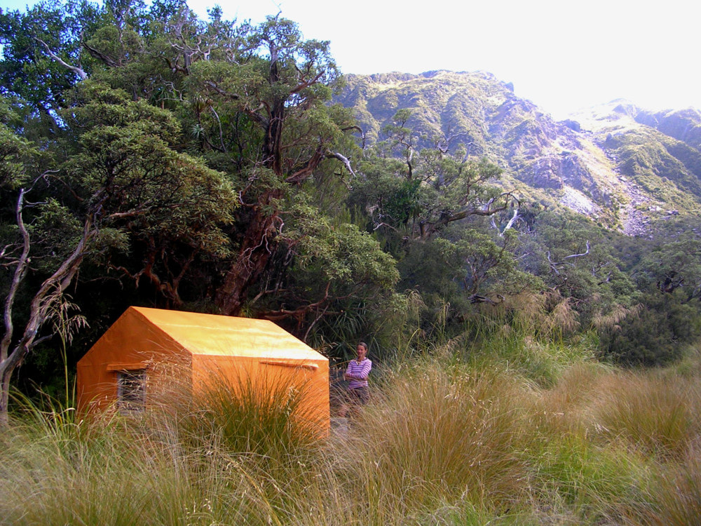
Lower Olderog Biv was designated for removal in DOC's 2004 High-Country Review, despite being in surprisingly good condition after 30 years of zero maintenance. It was being visited once every 3-5 years at the time, hardly surprising given the overgrown state of the access track and lack of publicly available route information. The Biv is located in the Waitaiki Historical Reserve which is overseen by Mawhera Corporation. In March 2014 Joke De Rijke, Geoff Spearpoint and I went in and painted and sealed the Biv and did some floor repairs. DOC provided the paint and a helicopter backload of materials. I continue to keep an eye on the route up from Lower Arahura which is in reasonably good shape. The Biv is getting 10-12 visits a year currently.
Location
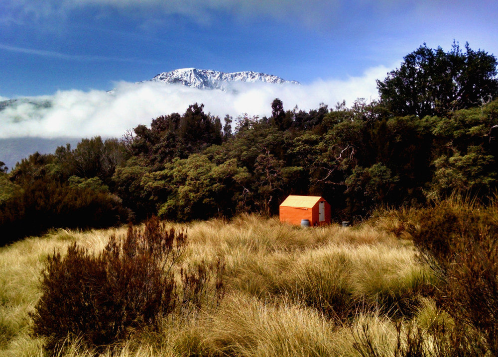
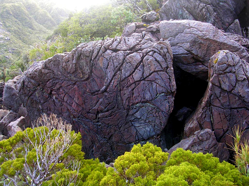
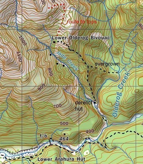
Arahura catchment. Grid Ref: E1461562/ N5255773 (BV19 616 558). Map BV19. Altitude 865m. Lower Olderog Biv is located at the edge of a tussock clearing in the sub-alpine zone above the TL of Jade Creek which was a key pounamu extraction area in the 1960's and 70's. There are two derelict private huts from that era way down in the Creek below the Biv. Above the Biv is an extensive open ultramafic rock band, and this provides relatively easy access onto the McArthur Crags. There is a good-sized rock biv in the alpine scrub 100m from the Biv that would sleep four quite comfortably. It was used by deer cullers before the Biv was built. Lower Olderog Biv can be accessed in 6-7 hours from the Arahura roadend by a reasonably fit party, or by way of a longer and more demanding traverse of Mt Kerr, and the McArthur Crags from the Big Wainihinihi valley.
Access
Access to Lower Olderog from the Arahura valley starts at the swingbridge 15 minutes upriver from Lower Arahura Hut. Cross the bridge and continue up the TR of the Arahura for around an hour to Olderog Creek. This section is mostly boulder travel with several short bush detours around the bluffier bits. Being the shady side of the valley, the rocks are wet and slippery for most of the colder months. The section up the TR of Olderog Creek to the Jade Creek confluence is a mix of track and rough boulder travel. There is a slip on this section that needs a bit of care to traverse, and a couple of large slippery logs that must be straddled where the creek cuts into a bluff. Head up Jade Creek for 100m past the confluence, exiting on its TL at the site of the derelict Jade Creek Hut.
The track to the Biv starts at the door of the Hut and goes up the ridge separating the Olderog and Jade catchments. It gets quite steep near the top and emerges in an open rocky ultramafic area at around 860m. There is a short climb through the rubble to around the 900m contour where cairns lead off the ridge in a NW direction and sidle across to an open scree. A short section of tracks takes you down through a band of stunted pink pine, and manuka to the tussock bench where the Biv is located. It is tucked in against the scrub edge and isn't visible until you are about 100m from it. The track up to the Biv is in good condition and was last trimmed and marked in November 2023.
Type
Lower Olderog is one of three remaining first batch, B49 bivs built by the NZFS in 1957. That it remained in good condition for over 30 years with no maintenance is a tribute to the simple wrap-around iron cladding design. It has a perspex window at the far end and two sleeping benches that were probably retrofitted in the early 1970's. There are no mattresses. Water is from a small creek about 5 minutes away and is accessed down a track at the top end of the clearing. A small roof-fed water barrel was placed next to the Biv in 2014. There is no toilet.
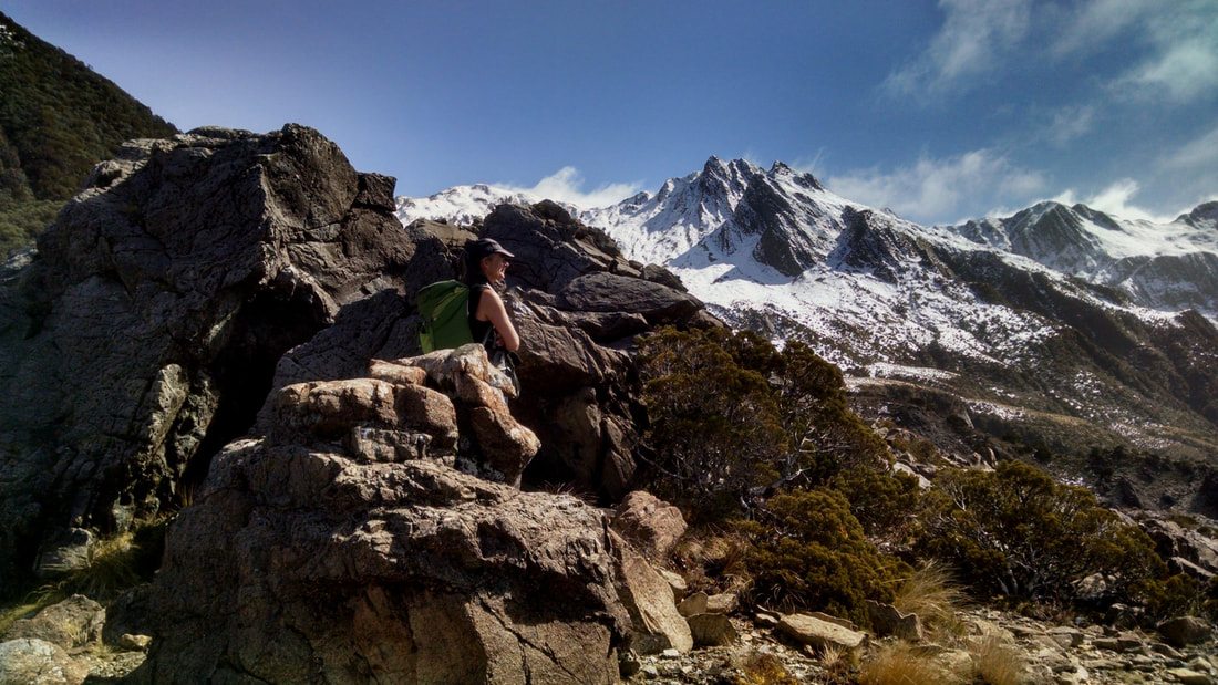 The Olderog Range from the ultramafic band above the Biv - Photo Andrew Buglass
Condition
Lower Olderog is currently weatherproof and in generally good shape. The 2104 working bee saw it painted rescue orange. A hole in the floor next to the door was repaired, the bottom plate replaced, and the door stud re-secured. A partially rotting bearer under the door was braced along its length with a 4x2. A purlin in the roof was replaced and two of the rafters braced for extra support. A flashing was constructed for the window, and a new latch put on. Any nails in the roof cladding that were lifting were replaced with tech screws. The door hinges have been replaced. A couple of the piles are on a bit of a lean, and the SE corner has dropped a bit. The floor remains sound, however. The bottom section of the middle pile is eaten out; however, it still feels pretty solid. The SE corner stud is dozy from dry rot and a damp patch has appeared on the floor in the SW corner, probably water seeping from snow build-up in winter.
Routes
The tops traverse to Lower Olderog over Mt Kerr and the McArthur Crags starts from the Hydro Road in the Big Wainihinihi River which is accessed via the Milltown Road in the Arahura Valley. There are two locked gates starting at about 2km along the road. To cycle the locked portions (7.5km) takes around 35 minutes. Another option for those coming from Christchurch is to turn off before Kumara onto the old West Coast Road and drive to Dillmanstown. From here it 9.5km (around 45 minutes) cycling along the new West Coast Cycleway to the start of the track.
The track up onto Mt Kerr starts at the unnamed creek on the big bend on the Hydro Road (E1461160/ N5260130 (BV19 612 601)). There is a routered sigh at its entrance is on the TL of the creek. The track climbs steeply up onto the ridge on the TL of the creek and follows it all the way to the tussock. It veers SW here and continues up through a band of alpine scrub to the top entrance at around 1150m. It is a mix of open tops and patchy scrub to the old trig site at point 1278m. There is a short dip then a steep section of ridge up onto Mt Kerr. The track was trimmed and marked in 2018 and checked in 2023.
Follow the crest of the Range from Mt Kerr to the McArthur Crags and drop down the SE spur from here towards the Olderog catchment. The spur has several sharp points which can be skirted on their southern sides. Climb up onto the last point and drop from it onto a flat area with three tarns. A stake with permolat at the northern edge of the bench (E1461531/ N5256404 (BV19 615 564)) indicates the drop-off point down a scrubby face to a second bench with cairns. Drop from the eastern end of this and follow a cut and marked trail across a scrubby gully to a saddle (E1461720/ N5256230 (BV19 617 562)) between a prominent ultramafic rock outcrop and the main hillside. Follow the cairns in a SW direction down a jumbled rocky gut towards the Biv clearing. The Biv itself is visible in fine conditions from the top of the ultramafic band. A fit party should be able to reach Lower Olderog Biv in 6-8 hours from the start of the Mt. Kerr track in good conditions. Add an extra hour if the gates are locked and you are walking the Hydro Road.
The McArthur Range has numerous good campsites and is relatively easy travel all the way around to Top Olderog Biv. There are numerous ups and downs and some steepish scrambles around small rock outcrops with plenty of vegetation to hold onto. Most of the traverse is reasonably easy going. The Biv is sited around 100 vertical metres down the Olderog side and is visible from the top in clear conditions. The drop off is from a dip in the Range at a small tarn at E1464406/ N5257814 and is marked with a waratah. Two more stakes lead down towards the Biv. Allow 4-6 hours from Biv to Biv.
Top Olderog Biv has been accessed from Lower Olderog via Olderog Creek, but would probably takes longer than the tops route. It is a steep drop from the ultramafic bench into the Creek, then are a couple of small gorges to negotiate followed by the climb from the creekbed up to Top Olderog. I attempted this route in 2006 but couldn't find a good route down from the bench into the Creek. It may be more doable coming the other way.
In the NZFS days there were tracks up both sides of the Arahura. The one on the TR followed a side-creek of the Olderog called The Trench, which runs above, and parallel to, the main valley. At around 675m an old NZFS track branches off the Lower Olderog Biv track and drops down into the mid-section of Olderog Creek. This was part of an old NZFZ trackline that went along The Trench to Newton Creek but hasn't been maintained for 50 years. The Trench itself is relatively easy creek travel, but the tracked sections down into Olderog Creek and from the head of The Trench to Newton Creek have vanished, and it's a real grovel. Interest expressed way back by a few Permolatters about reopening The Trench route to Newton Creek Hut. have long since dissipated.
Repairs needed.
The Biv needs repainting again. Some of the remaining flathead nails holding the iron roof and wall cladding may lift over time and can be replaced with the small tech screws on site. There is an 8mm ring spanner for screwing them in. That corner stud needs replacing, and a couple of piles could do with replacing at some point.
Provisions on site
Two plastic buckets, an aluminum bucket, an aluminum wash basin, a camp oven, three billies, a pot, a small frypan, a small sledgehammer, a shovel, a hammer, a tenon saw, a small phillips screwdriver, a small hacksaw, a hand broom, two paint brushes, 3 litres of grey enamel metal primer, 2 litres of white interior acrylic, assorted nails and screws, and a sealant gun. Underneath the Biv are some old lengths of tongue and groove, an old perspex window and frame, a few 6x1's, a 4x2, some black polythene, and a small sheet of iron cladding.
