Kakapo Hut

Maintenance Status
In 2004 DOC announced that they would no longer be maintaining Kakapo Hut. After a local protest they backtracked however by 2012 when they still hadn't done anything, Jason Campbell of Permolat who worked for DOC lobbied his employer to support a volunteer project. This maintenance took place in 2013. with DOC supplying materials and Jason and friends working for free. 2022 was another good year for Kakapo. The Back Country Trust used some of its Kaimahi for Nature funds to fly in an Ultimate Descents team to re-roof and seal the Hut.
Hut access had also suffered with zero official maintenance over the preceding decades. and by the early 2000's the routes into the Kakapo valley had overgrown, been buried in cyclone damage, or simply vanished. Visits to the Hut were mostly fly ins, with foot visits few and far between. In 2020 Louisa Hines and Hayden Miller did some work on the section from the Little Wanganui valley to Lawrence Saddle. Andrew Barker of Permolat followed up and between 2021 and September 2023 made three trips in to finish things off. The first on his own, the second with a CTC group, and the last with a little bit of input from me. The route crosses some challenging terrain and will be reliant on volunteer labour for to stay open.
Location
Karamea Catchment. Grid Ref: E1541722/ N5424106 (BQ23 417 241). Topo Map BQ23. Altitude 360m. Kakapo Hut is located midway up the TL of the Kakapo River, a major tributary of the Karamea River. The Hut was averaging around one visit per year during the 1990's and early 2000's due its remoteness and lack of extant tracks. There was brief surge in 2009 when six parties visited. From 2013 to 2022 visits were limited to DOC predator control, and the odd tramping group. Another surge of interest has followed Andrew's work which was profiled on this site and on Facebook. 2022 saw 15 non-DOC visits. By June 23 there had been 10 non-DOC and five DOC visits. DOC seems to have unlimited funds to fly in their biodiversity workers every few weeks but very little to spend on track and hut maintenance. It's ironic that Permolat and BCT are being thanked by these people for the good condition of the Hut and access routes. I'd recommend they carry some loppers and pruning saws when they check their tracking tunnels and do their bit to keep things the way we all like it. The plus side of this funding imbalance is that there is variety of birdlife reported around the hut, including robin, weka, kaka, whio, and kiwi.
Access
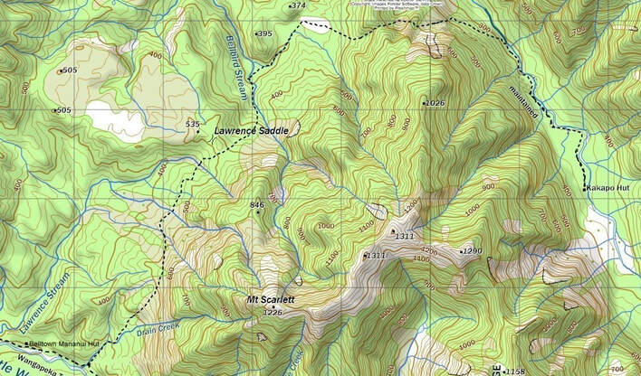
The route to the Kakapo valley from the Little Wanganui is not yet marked on NZ topo maps. The section that is marked as starting halfway up the valley side to the Hut is not an accurate line. The route starts at the old Belltown-Manunui hut site and heads up the TL of Drain Creek for a bit, then veers up a small, unmarked side-branch. The track climbs to around the 550m contour, sidles, and then drops 100 vertical metres into the upper branches of Lawrence Stream. From here there is an undulating sidle around to a bush saddle 100m SE of Lawrence Saddle. The track drops from here into the TL branch of Bellbird Stream entering the creekbed just above its confluence with the TR branch. It crosses the TL branch and cuts through a marshy area into the TR branch which is followed for a half kilometre to where the track exits at a prominent bend. A section of forest is traversed to the western end of an open swampy area which is crossed to the track start at its eastern end. A steep climb follows up to the unnamed saddle overlooking the Kakapo River from where track drops diagonally across some regenerating screes. There is a short steep climb onto an adjacent ridge from where a series of descents and sidles down through rough and rubbly terrain lead to a combined DOC trapline/ track at E1540779/ N5425767. This is marked with pink triangles and permolat and can be followed the remaining 2kms to Kakapo Hut. Parties seem to be averaging 6½ -8 hours to get from Belltown-Mananui Hut to Kakapo Hut. The track is good to go in most places but could do with a bit more tidying and marking on some of the sections from the unnamed saddle down to the trapline.
The route to the Kakapo valley from the Little Wanganui is not yet marked on NZ topo maps. The section that is marked as starting halfway up the valley side to the Hut is not an accurate line. The route starts at the old Belltown-Manunui hut site and heads up the TL of Drain Creek for a bit, then veers up a small, unmarked side-branch. The track climbs to around the 550m contour, sidles, and then drops 100 vertical metres into the upper branches of Lawrence Stream. From here there is an undulating sidle around to a bush saddle 100m SE of Lawrence Saddle. The track drops from here into the TL branch of Bellbird Stream entering the creekbed just above its confluence with the TR branch. It crosses the TL branch and cuts through a marshy area into the TR branch which is followed for a half kilometre to where the track exits at a prominent bend. A section of forest is traversed to the western end of an open swampy area which is crossed to the track start at its eastern end. A steep climb follows up to the unnamed saddle overlooking the Kakapo River from where track drops diagonally across some regenerating screes. There is a short steep climb onto an adjacent ridge from where a series of descents and sidles down through rough and rubbly terrain lead to a combined DOC trapline/ track at E1540779/ N5425767. This is marked with pink triangles and permolat and can be followed the remaining 2kms to Kakapo Hut. Parties seem to be averaging 6½ -8 hours to get from Belltown-Mananui Hut to Kakapo Hut. The track is good to go in most places but could do with a bit more tidying and marking on some of the sections from the unnamed saddle down to the trapline.
 Kakapo Saddle tracks. Note the red dotted line overlays the incorrect NZ Topomap line.
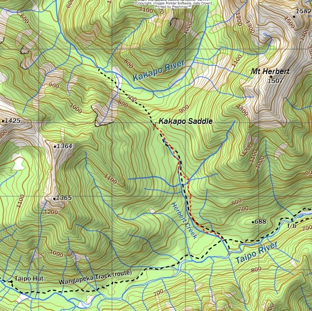
The other route to Kakapo Hut is from the Taipo valley via Kakapo Saddle. An old track up to the Saddle starts behind the Herbert Creek sign and was recut and marked in November 2022 by Andrew Barker. From the Saddle Andrew cut and marked a route in a NW direction along a bench above some bluffs. This then descends diagonally towards the valley floor crossing the bottom end of the big earthquake slip marked on the map and intersecting the Kakapo riverbed.
Travel down the valley on the TL is rough and bouldery initially with thick patches of regenerating beech until you get to the side-creek draining the Black Lakes. After this the river flattens and travel becomes a lot easier. The bush on the TL is mostly quite open with a discernible trail beginning to form in places. A DOC trapline can be picked up around E1543067/ N5421940 and followed for around an hour to the Hut. Allow 7+ hours to Kakapo from either Taipo Hut, Helicopter Flat, or the mid-Karamea huts.
When travelling upriver allow around three hours from Kakapo Hut to the start of the track over the Saddle. There is no marked route from the end of the DOC trapline to the track start at E1543860/ N5419710 and the section upriver of the creek draining Black Lake is fairly rough bush and boulder travel. Allow two hours from the start of the climb over to where the Herbert Creek track meets the Wangapeka track.
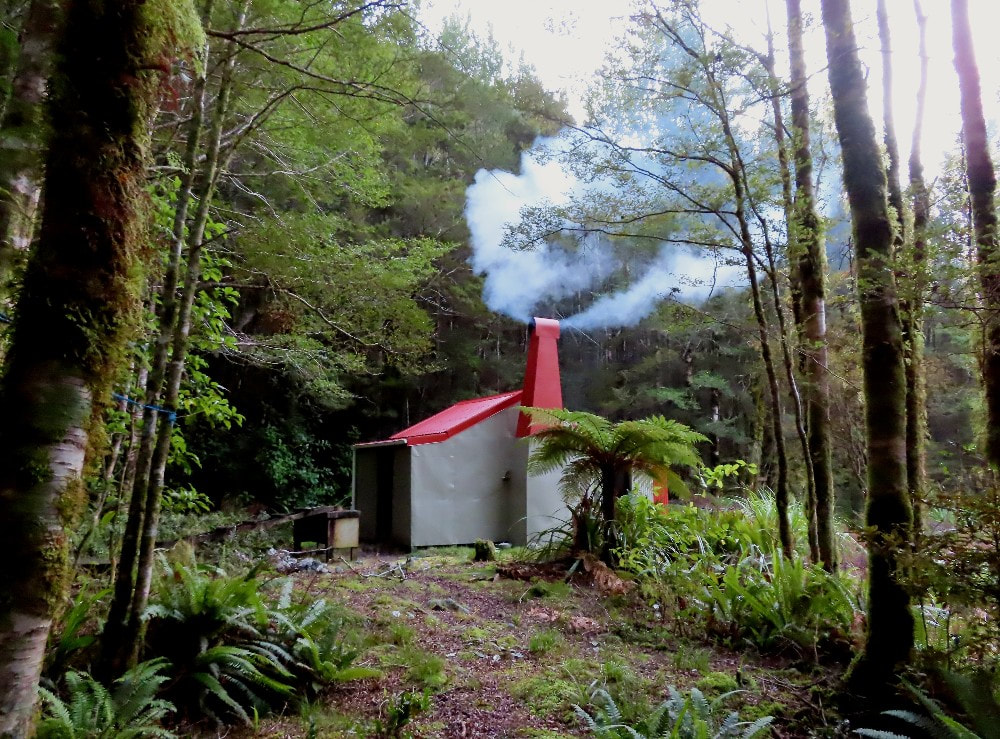
There is a helipad in front of the Hut.
Travel down the valley on the TL is rough and bouldery initially with thick patches of regenerating beech until you get to the side-creek draining the Black Lakes. After this the river flattens and travel becomes a lot easier. The bush on the TL is mostly quite open with a discernible trail beginning to form in places. A DOC trapline can be picked up around E1543067/ N5421940 and followed for around an hour to the Hut. Allow 7+ hours to Kakapo from either Taipo Hut, Helicopter Flat, or the mid-Karamea huts.
When travelling upriver allow around three hours from Kakapo Hut to the start of the track over the Saddle. There is no marked route from the end of the DOC trapline to the track start at E1543860/ N5419710 and the section upriver of the creek draining Black Lake is fairly rough bush and boulder travel. Allow two hours from the start of the climb over to where the Herbert Creek track meets the Wangapeka track.
There is a helipad in front of the Hut.
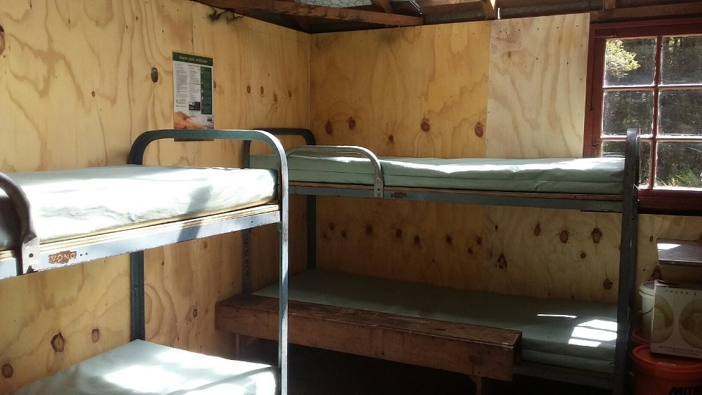 Refurbished Hut interior 2022
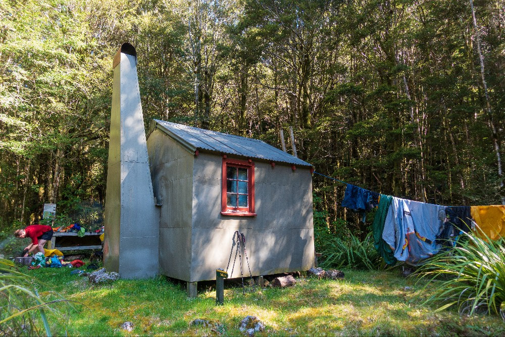
Type: Kakapo Hut is an unlined four-bunker with an open fire and two, four-paned windows. It was built in 1958 by the Nelson NZFS, a design characteristic of the era and predating the NZFS S81 four-bunk design that later became the high-country standard. Only a small number of this type were built, the only remaining one being Johnson Hut in the Mokihinui catchment. Building materials were flown in one of the earliest uses of helicopters by the NZFS (the first was Luna Hut). The Hut's door has the names of some of the early cullers and trampers inscribed on it. DOC wasn't able to fork out for hut repairs but did install a new long drop toilet at the site. The chimney smokes quite badly unless the main window is wide open possibly due to the chimney cap which was a later addition to stop rain entering.
Condition
Kakapo Hut is in very good condition now. In 2013 Jason's crew repainted the exterior, replaced the rusted chimney guttering, patched the chimney's rust holes, and replaced and painted the rotten window framing. A new hearth surround was constructed and wall studs, rotting floorboard sections, a pile and a bearer were replaced. The historic features such as names and old carved graffiti were left untouched. In March 2022 Pete Sinclair, Pete Braggins, and Marc Lesaicherre re-roofed the Hut, tidied up and lined some of the inside, and built a woodshed. In January 2023 a DOC team cut back some of the smaller regrowth around the front of the Hut. There is now a heap of firewood which should be seasoned by the summer of 23-24. There is one very small damp patch on the hut floor in the SE corner and a fair amount of mouse shit. There are a few poison blocks on site still.
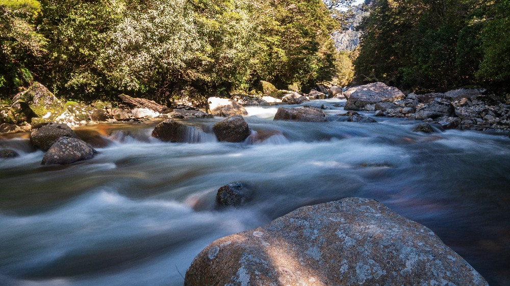 The Kakapo River: Photo Nina Dickerhof
Routes
The DOC predator line on the TL can be followed some distance downriver from Hut. A couple of parties have mentioned a route out from the lower valley over Mt Stormy. The track down from the summit to Karamea has been abandoned by DOC but is still followable.
There is mention in the hutbook at Greys Hut of an old track up the TL of the Karamea from the Kakapo confluence to opposite Greys (the book goes back to 1987). This would not have been maintained since the 1970's and there is no recent information on hand concerning this.
The Kakapo hutbook mentions a route up to Twenty Four Tarn Basin which sounds like a bit of a mission if you get it wrong. A party descending from the basin took 12 hours to get down after getting into trouble in a ravine or two. Other parties have described routes up to the Black Lakes from where it looks to be easy travel around to Little Wanganui Saddle.
Repairs needed.
No major ones currently. Might be worth checking what is causing that damp patch if someone is there during a wet spell.
Provisions on site
A broom, a dustpan and brush, three shovels, a crowbar, a bow saw, some plastic pails, an aluminium bucket, a camp oven, a small pot, a plastic basin, and an axe.
