Campbell Biv

Maintenance Status
Campbell Biv was designated for removal in DOC's 2003/ 4 High-Country Review. It was in remarkably good condition after 30 years of zero maintenance, but almost never visited. Few people would have known of its existence at the time, or how to get there. Shortly after making the remove decision DOC flew some volunteers in to repaint Campbell and wire down its piles, the first maintenance since 1974. The job was pretty much cosmetic however and it wasn't until 2017 that Paul Reid of Permolat with the help of Back Country Trust funding, did some serious work on the Biv. A more or less complete overhaul was completed in March 2019. Campbell is located in the Waitaiki Historical Reserve which is overseen by the Mawhera Corporation.
Location
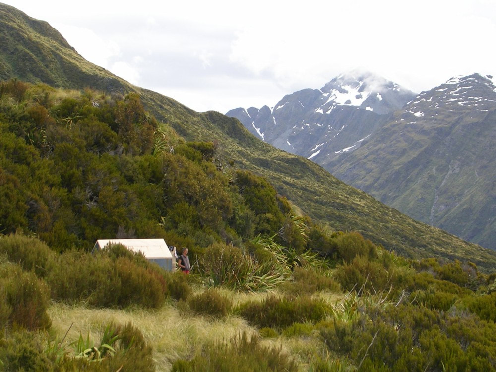
Arahura catchment. Map BV19. Grid Ref: E1465770/ N5249140 (BV19 658 491). Altitude 1105m. Campbell Biv is located at the scrubline on the Campbell Range on the TR of the Arahura valley. It is tucked in under a knoll on a spur that divides two large unnamed side-creeks and has a panoramic view out over Styx Saddle, and of the Newton and Browning Ranges. It is one of the least-visited huts on this site. A DOC fly-in hut check in 1994 found a roll of toilet paper that served as a hutbook with six visits recorded between 1974 and then. There was no sign of any further visits when I made my first trip there in 2001. An unopened NZFS food-drop under the bunk had its decaying contents wrapped in 1974 editions of the Hokitika Guardian. There was one tin of sardines still salvable. On my next visit in 2004 I found my route notes from 2001 lying undisturbed on the cooking bench. Apart from a gap in 2010, visits to Campbell Biv have averaged around two per year since it was profiled on this website. 2017 was a cracker year with seven visits recorded, then back to an average 1-2 stays. In February 2021 someone (?) started a fire during a very dry patch that burned through an extensive area of tussock and scrub around and above the Biv that needed to be put out by helicopters. Some well targeted monsoon drops saved the Biv from certain incineration. It now sits on a tiny island of green surrounded by hectares of charred vegetation.
Access
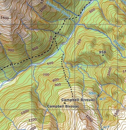
Campbell Biv can be accessed from the Styx or Arahura roadends. Up until 2017 there wasn't an official track up to it, and access was either via the tops, or by bush bashing up from the side-creeks on either side of the Biv site. In 2008 I marked a route up a dry gut from the northern creek catchment with a short connecting track from the gut to the tussock. In 2017 Eigill Wahlberg got consent from DOC to put a proper track that goes from the valley floor and connects with the top portion of gut. Currently the trackline is incorrectly marked on NZ Topomaps and a track they have marked down into the creek catchment upriver from the Biv doesn't actually exist.
The Campbell route starts from the Arahura valley track roughly halfway between Styx Saddle and Mudflats Hut. There is wooden sign with Campbell Biv at E1465512/ N5250689, indicating the start of the track down to the river. Note: This sign is on the left hand side of the track and can be missed if coming from Mudflats Hut. There is a good ford 100m downstream from where the track hits the Arahura riverbed opposite where the un-named access creek enters on the TR. Cross and boulderhop up this side creek for 2-300m to a large orange marker on the TL at E1465750/ N5250285. Don't be confused by the DOC stoat line lower down the creek that is marked with pink markers. The track leads up a broad spur, sidling into a dry gut at around 870m. The gut is followed up over an open slip back into the gut to a turnoff and short section of track that sidles East through the alpine scrub onto a narrow spur. Cairns lead up the ridge through patchy scrub to the base of a sloping rock face around 1080m. Waratahs lead West off the ridge and sidle across to the bench where the Biv is located. Allow 2-3 hours from Mudflats Hut or 9-10 hours from the Arahura roadend. Note: Fording the Arahura should only be attempted at normal or low flows. There is a cut, marked stoat line up the TR of the Arahura from Mudflats Hut that can used if the river is high, but this takes longer due to it climbing up and over a terrace.
The Styx valley route has suffered greatly from a series of extreme weather events in recent times and the old Browning Pass bench track on the TR has been taken out in a number of places. DOC is advising trampers to go via the Mid Styx Hut route on the TL, adding a good hour to the trip. It is still possible to go all the way up the TL using the old, benched track where possible or boulderhopping where it has been washed away. A fairly gnarly bush bash over some bluffs is necessary just above Tyndall Creek where the river has cut right in. Above this the track remnants or riverbed are pretty good travel, with more of the old bench intact as you get further up the valley.
When coming up the TL the Mid Styx detour can be avoided at low river levels by crossing back to the TR above Tyndall Creek and continuing up the original trackline where it isn't washed out. The best ford currently is around 200m upstream from Tyndall Creek (E1455138/ N5249878). This ford should definitely not be attempted if the river is running above normal levels. If this one isn't any good you may have to boulderhop upriver and find a place where it flattens and widens. For those using the Mid Styx route, the ford back to the TR is also prone to change. It is currently OK just below where the track drops back to the river. If not, you'll need to boulderhop upriver to find a better crossing. Don't attempt any of the crossings if the river is up. Allow 9-10 hours travel currently to Campbell Biv from the Styx road end.
There is an open patch next to the tarn by the Campbell Biv for helicopter access.
Type
Campbell Biv is a standard NZFS B49 design with flat iron roof and walls, and a single perspex window at the end. It was built by R.J. Courtney of Te Puke and K.W. Fisher of Nelson Creek on June the 5th and 6th 1958. Campbell was retrofitted with two raised wooden sleeping benches in November 1974 by Tony Newton, G. Stuart, and L. Bennett of the NZFS in Hokitika. A single mattress was dropped in during a DOC hut inspection. Water is from a small tarn 50m away and a bucket has been left next to the Biv to supplement this. There is no toilet.
Condition
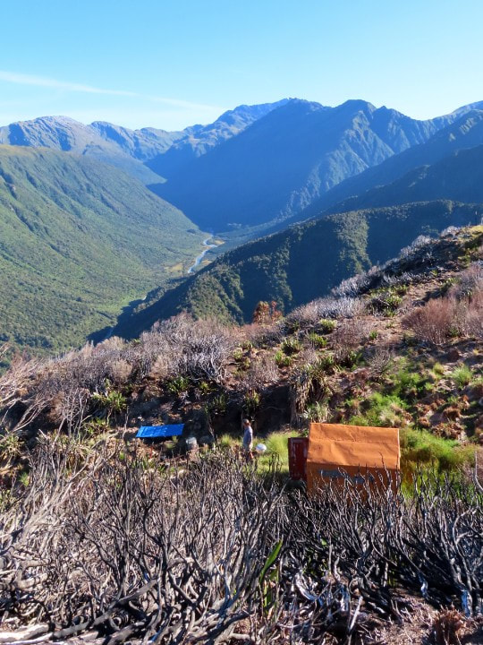
Campbell Biv was still reasonably intact when I visited in 2001 despite having received no maintenance between 1974 and 2004. This is a tribute to the simple, effective B49 bivouac design. There were the ubiquitous leaking issues however and semi-permanent dampness by 2017 had created significant areas of rot in the frame, floor and sub-floor which is all untreated rimu. Paul Reid and Alan Jemison did some work on it in April 2017, replacing as much of the rotten bits as they could, but ran short of timber to do all that was required. In March 2019 Paul, Alan, Wade Phelps and Andre Winkelman returned and did a virtual rebuild. The iron cladding was removed at the entire frame lifted off. New piles were put in and new joists, bearers, installed atop them. The original tongue and groove floor had its rotten bits replaced and reinstalled. New wall framing was constructed, and the old roof frame set atop using as many of the original bits as possible. The frame was enclosed in building wrap and iron cladding reattached. Silicone was applied to the laps, which were secured with hex-head screws. Flashings were made for the door and window and the door was strengthened. A frame was made for the window sash with its perspex glazing and fitted into the Biv. The iron cladding was rust-proofed, primed and painted. The cooking bench and bunks were reinstalled, and a concrete step was poured. Some waratahs were placed on the sidle across the tussock faces from the top end of the track. The Biv is in great condition currently. There was a little bit of water staining on the timber on the back wall in which may be internal condensation or winter snow seeping in. The paint on the door is flaking quite badly. The fire has caused a fair bit of the paint on the SW wall to blister and flake and melted some of the building paper on the inside. It is possible that the underlying iron cladding has suffered some kind of damage as well.
Campbell Biv was designated for removal in DOC's 2003/ 4 High-Country Review. It was in remarkably good condition after 30 years of zero maintenance, but almost never visited. Few people would have known of its existence at the time, or how to get there. Shortly after making the remove decision DOC flew some volunteers in to repaint Campbell and wire down its piles, the first maintenance since 1974. The job was pretty much cosmetic however and it wasn't until 2017 that Paul Reid of Permolat with the help of Back Country Trust funding, did some serious work on the Biv. A more or less complete overhaul was completed in March 2019. Campbell is located in the Waitaiki Historical Reserve which is overseen by the Mawhera Corporation.
Location
Arahura catchment. Map BV19. Grid Ref: E1465770/ N5249140 (BV19 658 491). Altitude 1105m. Campbell Biv is located at the scrubline on the Campbell Range on the TR of the Arahura valley. It is tucked in under a knoll on a spur that divides two large unnamed side-creeks and has a panoramic view out over Styx Saddle, and of the Newton and Browning Ranges. It is one of the least-visited huts on this site. A DOC fly-in hut check in 1994 found a roll of toilet paper that served as a hutbook with six visits recorded between 1974 and then. There was no sign of any further visits when I made my first trip there in 2001. An unopened NZFS food-drop under the bunk had its decaying contents wrapped in 1974 editions of the Hokitika Guardian. There was one tin of sardines still salvable. On my next visit in 2004 I found my route notes from 2001 lying undisturbed on the cooking bench. Apart from a gap in 2010, visits to Campbell Biv have averaged around two per year since it was profiled on this website. 2017 was a cracker year with seven visits recorded, then back to an average 1-2 stays. In February 2021 someone (?) started a fire during a very dry patch that burned through an extensive area of tussock and scrub around and above the Biv that needed to be put out by helicopters. Some well targeted monsoon drops saved the Biv from certain incineration. It now sits on a tiny island of green surrounded by hectares of charred vegetation.
Access
Campbell Biv can be accessed from the Styx or Arahura roadends. Up until 2017 there wasn't an official track up to it, and access was either via the tops, or by bush bashing up from the side-creeks on either side of the Biv site. In 2008 I marked a route up a dry gut from the northern creek catchment with a short connecting track from the gut to the tussock. In 2017 Eigill Wahlberg got consent from DOC to put a proper track that goes from the valley floor and connects with the top portion of gut. Currently the trackline is incorrectly marked on NZ Topomaps and a track they have marked down into the creek catchment upriver from the Biv doesn't actually exist.
The Campbell route starts from the Arahura valley track roughly halfway between Styx Saddle and Mudflats Hut. There is wooden sign with Campbell Biv at E1465512/ N5250689, indicating the start of the track down to the river. Note: This sign is on the left hand side of the track and can be missed if coming from Mudflats Hut. There is a good ford 100m downstream from where the track hits the Arahura riverbed opposite where the un-named access creek enters on the TR. Cross and boulderhop up this side creek for 2-300m to a large orange marker on the TL at E1465750/ N5250285. Don't be confused by the DOC stoat line lower down the creek that is marked with pink markers. The track leads up a broad spur, sidling into a dry gut at around 870m. The gut is followed up over an open slip back into the gut to a turnoff and short section of track that sidles East through the alpine scrub onto a narrow spur. Cairns lead up the ridge through patchy scrub to the base of a sloping rock face around 1080m. Waratahs lead West off the ridge and sidle across to the bench where the Biv is located. Allow 2-3 hours from Mudflats Hut or 9-10 hours from the Arahura roadend. Note: Fording the Arahura should only be attempted at normal or low flows. There is a cut, marked stoat line up the TR of the Arahura from Mudflats Hut that can used if the river is high, but this takes longer due to it climbing up and over a terrace.
The Styx valley route has suffered greatly from a series of extreme weather events in recent times and the old Browning Pass bench track on the TR has been taken out in a number of places. DOC is advising trampers to go via the Mid Styx Hut route on the TL, adding a good hour to the trip. It is still possible to go all the way up the TL using the old, benched track where possible or boulderhopping where it has been washed away. A fairly gnarly bush bash over some bluffs is necessary just above Tyndall Creek where the river has cut right in. Above this the track remnants or riverbed are pretty good travel, with more of the old bench intact as you get further up the valley.
When coming up the TL the Mid Styx detour can be avoided at low river levels by crossing back to the TR above Tyndall Creek and continuing up the original trackline where it isn't washed out. The best ford currently is around 200m upstream from Tyndall Creek (E1455138/ N5249878). This ford should definitely not be attempted if the river is running above normal levels. If this one isn't any good you may have to boulderhop upriver and find a place where it flattens and widens. For those using the Mid Styx route, the ford back to the TR is also prone to change. It is currently OK just below where the track drops back to the river. If not, you'll need to boulderhop upriver to find a better crossing. Don't attempt any of the crossings if the river is up. Allow 9-10 hours travel currently to Campbell Biv from the Styx road end.
There is an open patch next to the tarn by the Campbell Biv for helicopter access.
Type
Campbell Biv is a standard NZFS B49 design with flat iron roof and walls, and a single perspex window at the end. It was built by R.J. Courtney of Te Puke and K.W. Fisher of Nelson Creek on June the 5th and 6th 1958. Campbell was retrofitted with two raised wooden sleeping benches in November 1974 by Tony Newton, G. Stuart, and L. Bennett of the NZFS in Hokitika. A single mattress was dropped in during a DOC hut inspection. Water is from a small tarn 50m away and a bucket has been left next to the Biv to supplement this. There is no toilet.
Condition
Campbell Biv was still reasonably intact when I visited in 2001 despite having received no maintenance between 1974 and 2004. This is a tribute to the simple, effective B49 bivouac design. There were the ubiquitous leaking issues however and semi-permanent dampness by 2017 had created significant areas of rot in the frame, floor and sub-floor which is all untreated rimu. Paul Reid and Alan Jemison did some work on it in April 2017, replacing as much of the rotten bits as they could, but ran short of timber to do all that was required. In March 2019 Paul, Alan, Wade Phelps and Andre Winkelman returned and did a virtual rebuild. The iron cladding was removed at the entire frame lifted off. New piles were put in and new joists, bearers, installed atop them. The original tongue and groove floor had its rotten bits replaced and reinstalled. New wall framing was constructed, and the old roof frame set atop using as many of the original bits as possible. The frame was enclosed in building wrap and iron cladding reattached. Silicone was applied to the laps, which were secured with hex-head screws. Flashings were made for the door and window and the door was strengthened. A frame was made for the window sash with its perspex glazing and fitted into the Biv. The iron cladding was rust-proofed, primed and painted. The cooking bench and bunks were reinstalled, and a concrete step was poured. Some waratahs were placed on the sidle across the tussock faces from the top end of the track. The Biv is in great condition currently. There was a little bit of water staining on the timber on the back wall in which may be internal condensation or winter snow seeping in. The paint on the door is flaking quite badly. The fire has caused a fair bit of the paint on the SW wall to blister and flake and melted some of the building paper on the inside. It is possible that the underlying iron cladding has suffered some kind of damage as well.
 Looking North along the Campbell Range from the ridge above the Biv.
Routes
There is a reasonably good high-level route to Campbell Biv from Harman Hut in the head of the Arahura. Head up the Browning Pass track from Harman Hut and drop into the Arahura at the first open side-creek. Cross the River and climb up a small side-creek that comes in on the TL at E1463625/ N5246428 (BV19 636 464). The creek is a natural staircase, a series of small cataracts. Exit the creek up a gut on its TR about 2/3 of the way up and climb onto the tussock bench above. Sidle from here up and around to the upper basin of Sphinx Creek taking care to stay above the large waterfall at its lip. Exit the basin up a small side-creek that enters on the TR just below where the main creek forks. Climb out of the side-creek and up a dry gut on the TR near its top. This provides access onto a side-spur that leads to the main spur dividing Sphinx Creek and the unnamed creek catchment South of the Biv. Drop into the the upper basin of this creek and sidle across some scree slopes onto the Biv ridge. The Biv doesn't come into view until you are about 100m above it. Allow 4-5 hours from Harman Hut to Campbell Biv in good conditions.
The Campbell Range NE of the Biv can be accessed directly up the spur behind the Biv to where an obvious tussock gully leads down into the creek below. Sidle up the sloping tussock benches above the stream to around the 1250m mark where it is possible to drop into the creek bed. Climb up the slopes on the other side onto a bench at 1420m with shallow tarns, sheltering rocks, and good camp sites. From here an easy slope leads up onto the crest of the Range and a bench system on the Julia side offers fast travel North to point 1673m. The benches also run south towards Mt Axis and the views from this side are very worthwhile. From point 1673m there is an easy descent to the tarn marked on the map and there are good campsites by some unmarked tarns just below this. The top end of an old NZFS track down to Mudflats Hut can be located further down at the bush-edge (around E1477643/ N5250946 (BV19 676 509)). This was recut and marked by Bruce McClelland et al in 2017.
Old Julia Hut in the Taipo valley can be accessed from the low point between points 1673m and 1682m on the Campbell Range. Drop from here onto the flat area at 1450m on the TL of the TL fork of Dexter Creek. Drop SE from here down a steep shingle scree between some bluffs into the unnamed side-creek below and follow this down to Julia Creek. Ford to the TR and continue down the track for 15 minutes to the huts. Julia Creek can be tricky to ford after rain, so this is a fine-weather-only route. The Julia Creek track was given a trim by Eigill Wahlberg in 2022.
Repairs needed.
DOC apparently have a hygiene thing with the traditional galvanised iron top on the cooking bench and would love us to replace it with a PC stainless steel one, but hey!! A water barrel with a roof collection gutter would be an improvement as the tarn is staring to moss over and gets a bit tepid during drier periods (the tadpoles are a good source of protein). The door, window frame, and the SW wall need repainting. An inside latch on the door would be a help. Tom Hanchett has left a pot of paint on the track, 20m below the junction of the Campbell biv route on the Mudflats - Styx Saddle track. It's in a thick blue plastic bag. Anyone heading up that way is welcome to carry it up and do the work. A scraper, some sandpaper, and a small quantity of metal primer needs to go up as well.
Provisions on Site
Two billies (the big one has a lid), a frypan, a 5-litre plastic paint bucket, an antique first aid kit, an aluminium wash basin, scissors, a small quantity of permolat, a flax knife, a broom, a spade, and a hand brush and shovel. There is a still useable camp stretcher under the bunk and a sleeping mat. There is a heap of timber off-cuts and odds and sods, and old piles under the Biv.
