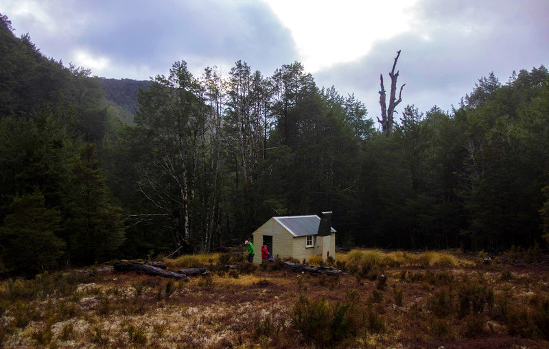
Wheel Creek Hut


Maintenance Status
Wheel Creek Hut is designated as minimal maintenance. The route up to it is not officially maintained but volunteers are hopefully keeping an eye on it.
Location
Maruia River catchment. Map BS22. Grid Ref: NZTM E1528176/ N5342003 (BS22 282 420). Elevation 810m. Wheel Creek Hut is located in a large clearing on the TR of Wheel Creek. It has received few visitors in recent years due to the lack of a suitable marked route, and good access information. An uncut marked route was established in 2010.
Access
Access to Wheel Creek is gained from Boundary Road, which turns off SH65 at Warwick Junction, North of Maruia. Cross the Maruia River and turn right at the Ringmer farm turnoff, just after the bridge. Permission to travel up the farm road is required from the owner, Peter Brooker (03 523 8884). 2WD vehicles can be driven well past Mitchell Creek and a 4WD will get you to the end of the farmland just before Jones Creek (E1533647/ N5339453 (BS22 336 395)). It gets too boggy after this and there is nowhere to turn. Wheel Creek is around 30 minutes walk from here.
The Wheel Creek route as marked on the old topo maps is no longer accurate. A more recent route marked with orange triangles starts from the large orange triangle at Wheel Creek and goes up onto the terrace on the Creek's TL. Head along this for a bit, then sidle through a steep gully onto a prominent spur. The route goes up this a short distance, sidles to an adjacent spur, and drops down it. A long, high and rough sidle ensues across a steep section of the valley, with bush lawyer and beech spars hampering progress. The markers are not always visible on this section, at the end of which is a steep drop down to a side-creek. From here it is reasonably straightforward river travel over flats and terraces, on the TL initially, then the TR for the last bit of the journey. The markers cross and re-cross the Creek regularly, but some of these are not absolutely necessary.
For the more sure-footed and bush savvy, it is possible to ignore the route and follow Wheel Creek all the way to the Hut. A couple of small sidles of 50 metres or so are necessary where the river gradient steepens. Allow 4-5 hours from the bottom of Wheel Creek to the Hut. Triangles that are not orange are for goat survey blocks, and should be ignored. A vegetation trim along the steep section of the route would make travel much easier. Any updates on route conditions can be given to Sam Symonds at [email protected].
Type
Wheel Creek is a standard six-bunk NZFS S70 design with open fire, probably built in the 1960's. It has only four mattresses. In 2004 it was repainted and some trees were felled around the site to allow more light in. The open fire is somewhat smoky with the window closed. There is no toilet.
Condition
Wheel Creek Hut is in excellent condition currently, although it is susceptible to mouse infestation.
Routes
A tops traverse along to Kirwan’s Hut is possible from Wheel Creek along the range that divides the Awarua and Montgomerie catchments. Climb the steep gully up to Waitahu Saddle, a scramble towards the top, then follow the crest from here. Some patches are a bit scrubby, or require a small traverse, but most are in mixed beech forest and make for a nice crossing. The only water sources en route are a couple of small tarns at a picturesque campsite a few hundred meters SE of Point 1263m and a large tarn at the eastern end of the Kirwans Hill tops. The route is marked from south of point 1315m to Kirwans Hut. Allow 7-8 hours for the crossing.
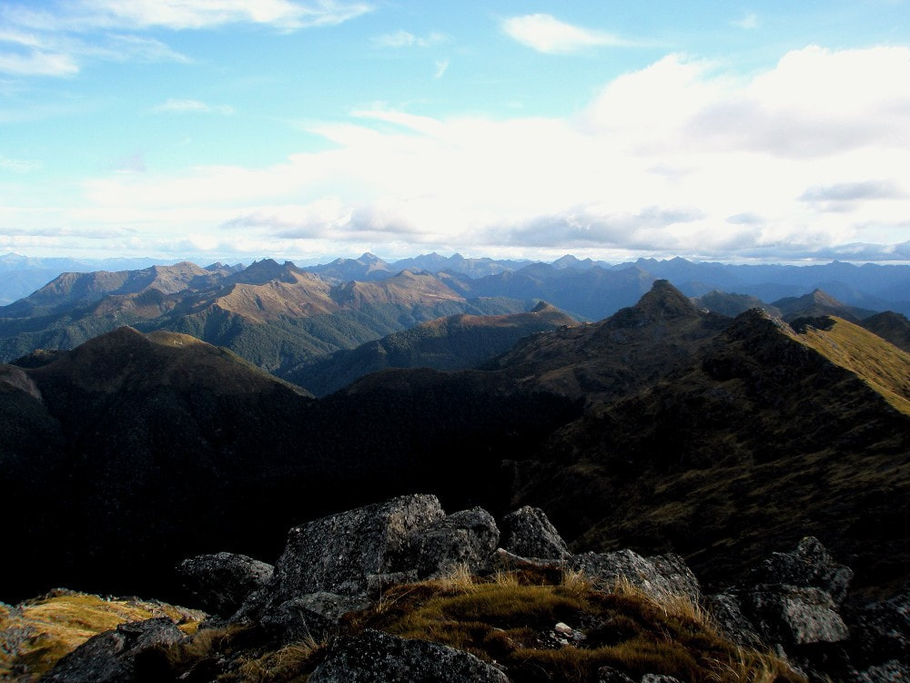 The Northern Victoria Range - Photo Tom Hanchett
The Victoria Range south of Larry Saddle is fairly easy travel initially but becomes increasingly demanding closer to Ivess Peak. There are no recordings of anyone making the full traverse from Larry Saddle to Lake Stream Hut in any of the current hut books.
From Peter Brooker’s Farm an overgrown stock track can be followed to the bush line below Creighton Peak. Peter is approachable and it is best to ask him where to find this route. The ridge can be followed over or around Mt. Crosscut and onto Waitahu Saddle. There are tarns with good campsites from Mt. Crosscut onward. It is better to drop directly off Waitahu Saddle than take a seemingly more direct line into Wheel Creek.
A route to the Awarua/ Larry River involves continuing up the TR of Wheel Creek to the first marked side-creek. A light track goes up the TL rib of the creek towards the Saddle from where there is a grand view down Silcock Creek and over to the surrounding peaks. It is straightforward travel down the top basin of Silcock Creek, with goats further down on the flats, and some great camping spots. Head up the broad spur at the bottom end of the basin, on the TR of the side-creek that drains the tarn and point 1302m. The tarn there is shallow and lacks a sheltered campsite. Continue along the long NW ridge from point 1302m. Navigation skills are required at the top, but the remainder down into the Larry River is straightforward. Getting off the toe of the ridge is not particularly easy, and the 400m of river travel from here down to the Larry River forks involves some pack-floats at normal flows. This section would become impassable with rain and sidling is not practical here. Further down the Larry a sidle on the TR above some gorgy sections is required, and not river travel as recommended in Sven Brabyn's guide. The first reasonable camping spot is the marked flat above the Bateman confluence. Rounded river rocks could make for difficult crossings in places at above-normal flows. A useful section of pack-track can be picked up on the TL below the 230m contour, and the river broadens eventually, and wading becomes more pleasant. Continue down to the Caledonian Mine and the marked track out to the road.
The Northern Victoria Range allows for fairly easy travel with small traverses, or a little scrambling required around some of the peaks. It is dotted with tarns all the way, so one wouldn’t need to carry water for more than half an hour. Mt Ralph with its sheer northern and western faces can be easily traversed on its eastern shoulder. Approaching from the south can be best done via the small catchment draining the southern side of the peak. One could allow 3-4 hours from Larry Saddle to Mt Victoria, 2-3 hours from there to Mt Pelion, and 4 hours from there to Mt Wynn. The Brunner Range from Mt Wynn to Mt Curtis Hut is easy travel with numerous small tarns.
Repairs
None currently. Rodent proofing would make the hut more comfortable in plague years. If hut usage increases to a significant level, a toilet would be required.
Provisions on Site
There is a range of pots and pans, a steel ash bucket, and a broom.
