MT CurTis Hut
Maintenance Status:
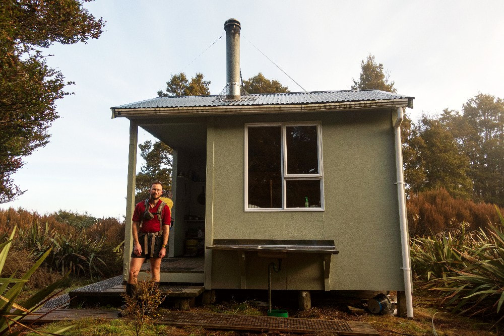
Mt Curtis Hut is a community built and maintained hut, open to the public on a donation for use basis. It was built with Department of Conservation permission in 2002 to replace a derelict, unconsented hunter’s hut built in the early 1970s out of beech poles and tin. The new hut's construction was initiated and mostly funded by locals Hamish and Warren. Additional donations and practical help were provided by the local community, although Warren did most of the building, which is to modern standards but with character and a personal touch. The usual access is via a community-maintained track from SH6 near Inangahua.
Location:
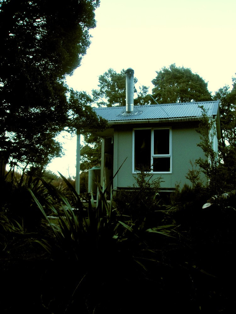
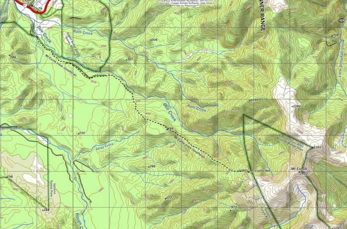
Northern Brunner Range, 1.4km west of Mt Curtis. NZ TopoMap: BS22, Shenandoah. Grid Ref: NZTM E1520858/ N5360985. Altitude 1185m. Mt Curtis Hut is located near the northern end of the Brunner Range, tucked away at the bushline, on the spur separating the Rough and Dee Creek catchments. The hut can be accessed in half a day from SH6 and provides easy access to the tops. It is readily visible from above and while you can't see the Inangahua valley from it there are good views back up towards the tops. The hut in a very sheltered spot with all day sun and gets around a dozen recorded parties each year, most of whom are chamois/ red deer/ pig hunters.
Access:
The community-maintained track from SH6 is not currently marked on NZ Topomaps and was recut when the hut was built. It is currently fairly well marked, mostly with pink flagging tape, and is in good condition. The route starts by following up Dee Creek which is initially bounded by private land on its TR and rough, bluffy DOC land on the TL. The creek bed is rocky, wide, and easy to walk up at low flows. The track proper starts at the first side-creek on the TL (E1514930/ N5364894) but the bank has slipped away and overgrown there and it’s easier to keep following Dee creek for a few hundred meters, then cut through the beech forest onto the terrace, and pick up the track which runs parallel to the creek. The track follows the most logical path from here to the hut, climbing slowly along old river terraces, then steeply once you reach the spur. At a good pace, allow for four hours up to the hut and three back down.
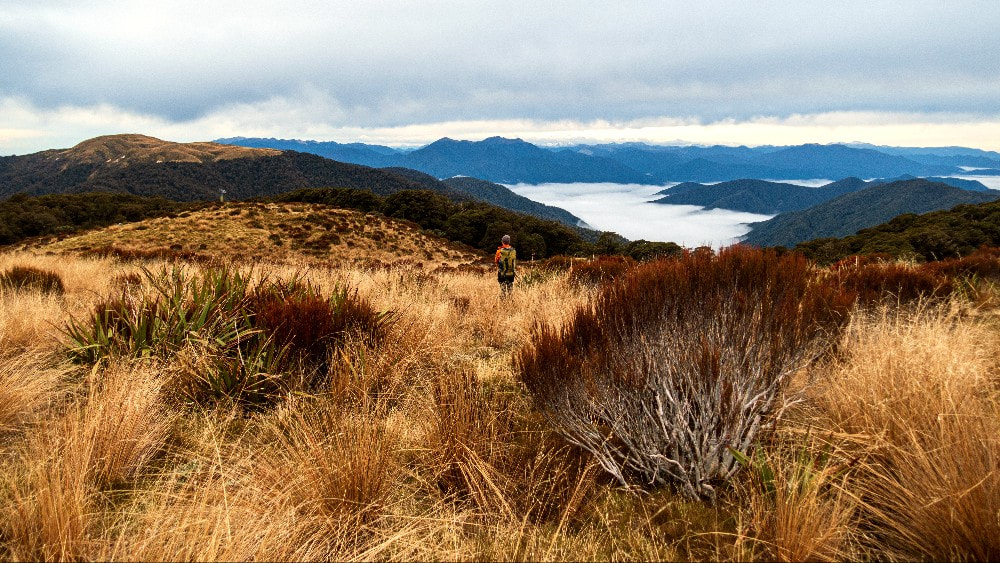
The Brunner Range provides easy, open travel from the hut in both directions and although there are no marked tracks along the tops, navigation is straightforward in good conditions. Mt Curtis Hut is sited at the bushline, with a band of scattered alpine scrub between it and the open tops. There is a roughly cut track up through the scrub with the odd bit of marking, but travel is easy enough anyway.
Type:
Mt Curtis Hut is not a standard DOC design and has been built with a friendly feel about it. It has four bunks, a woodburner, a table, and a covered entranceway. Outside there is a woodshed, an outdoor cooking area with a kitchen bench and sink and lots of hooks and washing lines. There is a roof-fed water tank and a toilet.
Condition:
The Hut is currently in excellent condition with all day sun keeping the interior nicely dry.
Routes:
The tops north of Mt Curtis are easily traversed including the section where the ridgeline dips into the bush. There is an old hut just NE of Boundary Peak which is reputedly damp, and mouse infested. An old mustering track cut in the 1960s that led from here down the NW spur over Points 770m and 704m to the Iron Bridge on the highway may have some flagging on it but is not actively maintained.
There is an untracked route down Boundary Peak's SW spur into Ram Creek through fairly open beech forest. Ram Creek itself is relatively easy travel.
The Brunner Range south of Mt Curtis is very easy travel all the way to Bourkes Rock with scattered tarns along the way providing lovely camp sites. There isn't any flagged or cut route from Bourkes Rock down to Larry River and while the bush is pretty open, the stream at the bottom is a bit rough. There was also an old mustering track down the spur between Landing and Dunphy Creek, that Hamish Roundhill (021 471 201) has done a bit of cutting on and loosely flagged. The top end of the route is hard to locate, and it ends up on Hamish's farm. He is happy to provide access and directions for trampers and hunters if they ring him in advance.
Larry Saddle and Wheel Creek Hut can be accessed via the northern Victoria Range. The ridgeline allows for fairly easy travel with small traverses, or a little scrambling required around some of the peaks. Like the Brunner Range, it is dotted with tarns all the way, so one wouldn’t need to carry water for more than half an hour. Mt Ralph with its sheer northern and western faces can be easily traversed on its eastern shoulder. Approaching from the south can be best done via the small catchment draining the southern side of the peak. One could allow 4 hours from Mt Wynn to Mt Pelion, 2-3 hours from Mt Pelion to Mt Victoria, and 3-4 hours from Mt Victoria to Larry Saddle. A light track goes down the TL rib of the side-creek that runs under the Saddle and from here it should be straightforward travel down Wheel Creek to the hut.
Mt Curtis Hut is a community built and maintained hut, open to the public on a donation for use basis. It was built with Department of Conservation permission in 2002 to replace a derelict, unconsented hunter’s hut built in the early 1970s out of beech poles and tin. The new hut's construction was initiated and mostly funded by locals Hamish and Warren. Additional donations and practical help were provided by the local community, although Warren did most of the building, which is to modern standards but with character and a personal touch. The usual access is via a community-maintained track from SH6 near Inangahua.
Location:
Northern Brunner Range, 1.4km west of Mt Curtis. NZ TopoMap: BS22, Shenandoah. Grid Ref: NZTM E1520858/ N5360985. Altitude 1185m. Mt Curtis Hut is located near the northern end of the Brunner Range, tucked away at the bushline, on the spur separating the Rough and Dee Creek catchments. The hut can be accessed in half a day from SH6 and provides easy access to the tops. It is readily visible from above and while you can't see the Inangahua valley from it there are good views back up towards the tops. The hut in a very sheltered spot with all day sun and gets around a dozen recorded parties each year, most of whom are chamois/ red deer/ pig hunters.
Access:
The community-maintained track from SH6 is not currently marked on NZ Topomaps and was recut when the hut was built. It is currently fairly well marked, mostly with pink flagging tape, and is in good condition. The route starts by following up Dee Creek which is initially bounded by private land on its TR and rough, bluffy DOC land on the TL. The creek bed is rocky, wide, and easy to walk up at low flows. The track proper starts at the first side-creek on the TL (E1514930/ N5364894) but the bank has slipped away and overgrown there and it’s easier to keep following Dee creek for a few hundred meters, then cut through the beech forest onto the terrace, and pick up the track which runs parallel to the creek. The track follows the most logical path from here to the hut, climbing slowly along old river terraces, then steeply once you reach the spur. At a good pace, allow for four hours up to the hut and three back down.
The Brunner Range provides easy, open travel from the hut in both directions and although there are no marked tracks along the tops, navigation is straightforward in good conditions. Mt Curtis Hut is sited at the bushline, with a band of scattered alpine scrub between it and the open tops. There is a roughly cut track up through the scrub with the odd bit of marking, but travel is easy enough anyway.
Type:
Mt Curtis Hut is not a standard DOC design and has been built with a friendly feel about it. It has four bunks, a woodburner, a table, and a covered entranceway. Outside there is a woodshed, an outdoor cooking area with a kitchen bench and sink and lots of hooks and washing lines. There is a roof-fed water tank and a toilet.
Condition:
The Hut is currently in excellent condition with all day sun keeping the interior nicely dry.
Routes:
The tops north of Mt Curtis are easily traversed including the section where the ridgeline dips into the bush. There is an old hut just NE of Boundary Peak which is reputedly damp, and mouse infested. An old mustering track cut in the 1960s that led from here down the NW spur over Points 770m and 704m to the Iron Bridge on the highway may have some flagging on it but is not actively maintained.
There is an untracked route down Boundary Peak's SW spur into Ram Creek through fairly open beech forest. Ram Creek itself is relatively easy travel.
The Brunner Range south of Mt Curtis is very easy travel all the way to Bourkes Rock with scattered tarns along the way providing lovely camp sites. There isn't any flagged or cut route from Bourkes Rock down to Larry River and while the bush is pretty open, the stream at the bottom is a bit rough. There was also an old mustering track down the spur between Landing and Dunphy Creek, that Hamish Roundhill (021 471 201) has done a bit of cutting on and loosely flagged. The top end of the route is hard to locate, and it ends up on Hamish's farm. He is happy to provide access and directions for trampers and hunters if they ring him in advance.
Larry Saddle and Wheel Creek Hut can be accessed via the northern Victoria Range. The ridgeline allows for fairly easy travel with small traverses, or a little scrambling required around some of the peaks. Like the Brunner Range, it is dotted with tarns all the way, so one wouldn’t need to carry water for more than half an hour. Mt Ralph with its sheer northern and western faces can be easily traversed on its eastern shoulder. Approaching from the south can be best done via the small catchment draining the southern side of the peak. One could allow 4 hours from Mt Wynn to Mt Pelion, 2-3 hours from Mt Pelion to Mt Victoria, and 3-4 hours from Mt Victoria to Larry Saddle. A light track goes down the TL rib of the side-creek that runs under the Saddle and from here it should be straightforward travel down Wheel Creek to the hut.
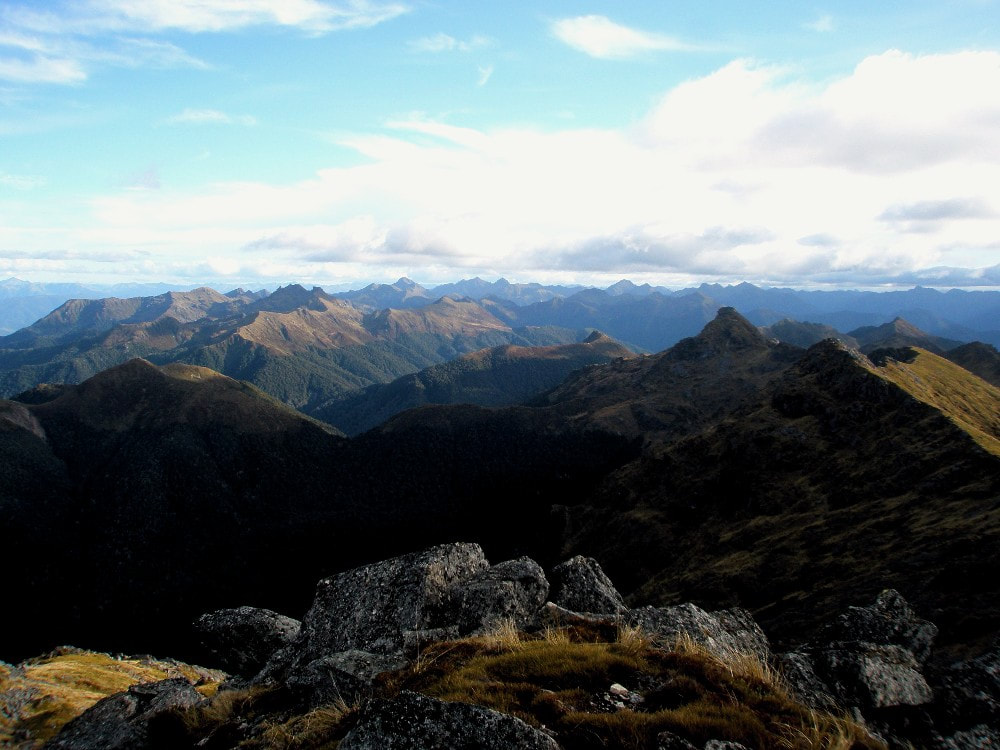 The Northern Victoria Range - Photo Tom Hanchett.
The prominent ridgeline starting south of Larry Saddle makes for good travel all the way to Kirwans Hill and seems to be walked once every couple of years. Some patches are a bit scrubby, or require a small traverse, but most are in mixed beech forest and make for a nice crossing. The only water sources en route are a couple of small tarns at a picturesque campsite a few hundred meters SE of Point 1263m and large tarn at the eastern end of the Kirwans Hill tops. The route is marked from south of Point 1315m to Kirwans Hut. One should allow 6-8 hours for the traverse from Larry Saddle to Kirwans Hill.
The Victoria Range south of Larry Saddle is fairly easy travel initially but becomes increasingly demanding closer to Ivess Peak. There are no recordings of anyone making the full traverse from Larry Saddle to Lake Stream Hut in any of the current hut books.
Repairs needed:
Nil currently. The track will need some maintenance work soon (mostly pruning) for anyone who may be interested. Marking the track with permolat would also be a great project for increasing its longevity into the future.
Provisions on site:
Four mattresses, a range of pots and pans, a broom, a dustpan and brush, pegs, an axe, a saw, and various building and painting tools.
