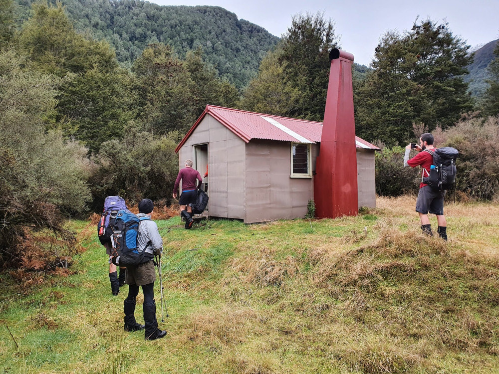
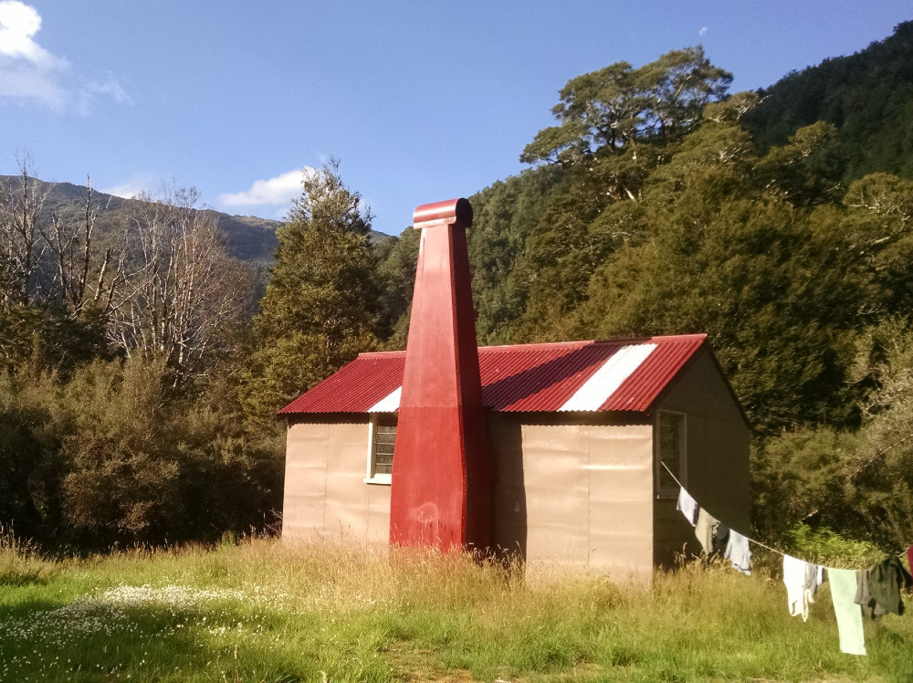
Waikiti Hut

Maintenance Status
Waikiti is a maintain-by-community Hut with Craig Benbow as signatory intending to do some maintenance at some point. DOC did some chainsaw and marking on the access track some time back and in 2019 Charlie Ledbrook led a group of Permolat and Over Forties Tramping Club members to do more work on it. Back Country Trust funded Charlie's project. Charlie and his team installed a ladder on an exposed rock in section in one of the side-creeks. DOC did some anchor replacements on the swingbridge in the mid-valley but reneged on a full safety upgrade. To avert the bridge being pulled out BCT offered to part-fund the additional work with Permolat Trust contributing $5K to fund the shortfall. The work was carried out in 2021 by an Abseil Access team.
Early 2021 saw trackwork carried out on the Crane Creek/ Rochfort Basin route into the Waikiti by Mauricio Lloreda and friends. This was funded with some leftover Outdoor Recreation Consortium (BCT's precursor). In September of that year, I added some finishing touches to the Logjam creek section of the route, and I gave the main valley track a rough trim on my way out.
Location
Ahaura catchment. Ref: NZTM2000 E1506000/ N5281370 (BU21 060 814). Topo50 Map BU21. Altitude 445m. Waikiti Hut is located on a flat midway up the TR of the Waikiti River, which is a major tributary of the Ahaura River. Prior to the trackwork in 2009 the Hut was receiving extremely low numbers of walk-in visitors and was mostly the preserve of fly-in hunters. Recent parties have remarked on the abundance of kaka in the valley, and here is also a healthy robin population. Whio can also be encountered in various stretches of the river.
Access
Access up the Waikiti valley starts from the road bridge on the TR of the River. The DOC sign states seven hours, but it can be done in five a fast party using the river instead the last bit of track before the hut. The track starts on the TR at the bridge on the Haupiri-Amuri Road. It climbs up and around a gorge and does an undulating sidle for the first couple of hours before dropping down to the river and the bridge to the TL. There follows a short section of track, then a short section of river travel to a slip which provides access to a tracked section around a second gorge. This bit is rough and undulating with a couple of regenerating slips to cross. It then drops to an uncharacteristically flat section next to the river. The track can be followed from where it climbs again however it is easier and much quicker to follow the river if it's not up. Some wading and fording will be necessary, so it is a dry weather only option. The track is still reasonably good condition with the odd patch of fresh windthrow downstream from the bridge. It is also starting to overgrow a bit in several places where it could do with a trim. Allow around six hours currently from the roadend to the hut.
The regenerating flat downstream from the hut provides helicopter access (there was once an airstrip here).
Type
Waikiti Hut is an NZFS six-bunk S70 design with an open fireplace, built in the 1960’s. The toilet is 50m back downriver from the Hut. There is water in a small creek 100m west of the Hut.
Condition
DOC painted Waikiti Hut in 2005, reconditioned it in 2009, and recently came in again and repainted the chimney. The internal hearth surround is shot and needs replacing. The Hut is dry and sound except for one tiny damp patch on the floor at the end window. Three of the piles are rotting at their bases and the window frames need painting. The outer door bolt is pretty stuffed and needs replacing. The hut has been plagued with rats at times and they have been chewing into the mattresses but seemed OK in May '24. Please stand the mattresses on their sides when you leave. It stops them getting damp and the rats getting underneath and making nests. Use the poison blocks and bait stations left there (thanks to Indy Hawthorne for supplying them).
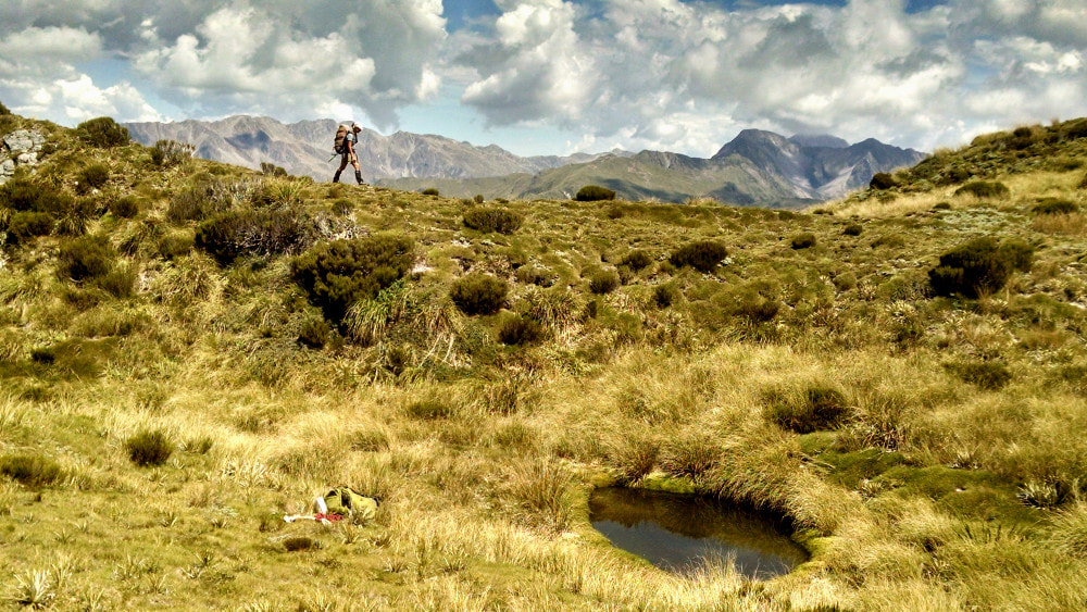
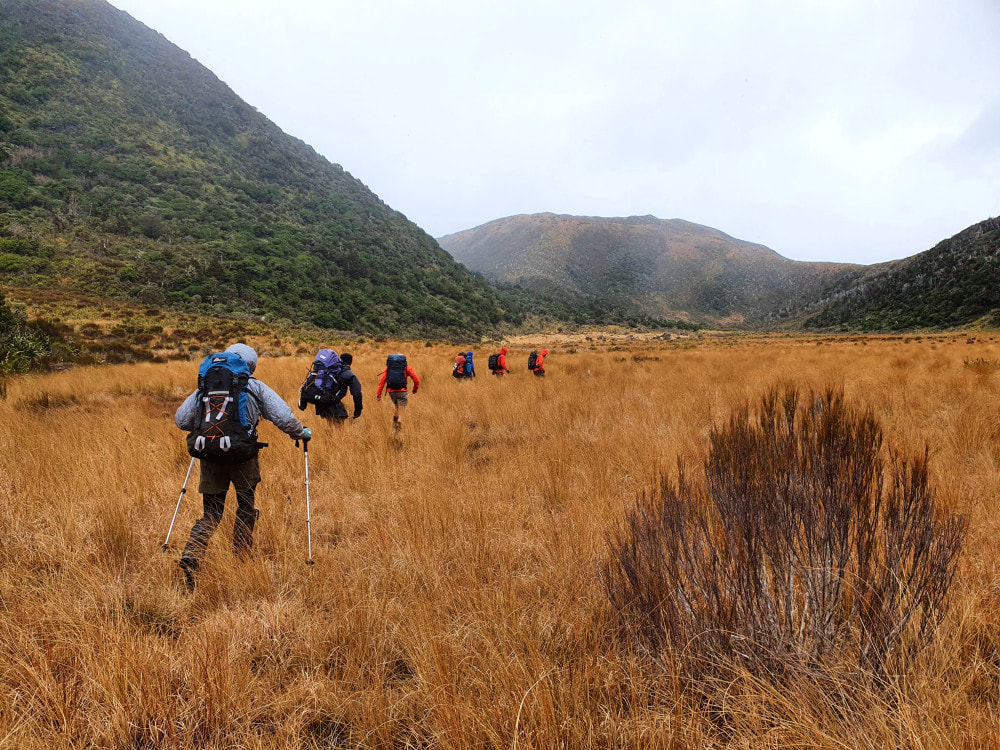 Heading up Rochfort Basin - Photo Liz Wightwick 2021
Routes
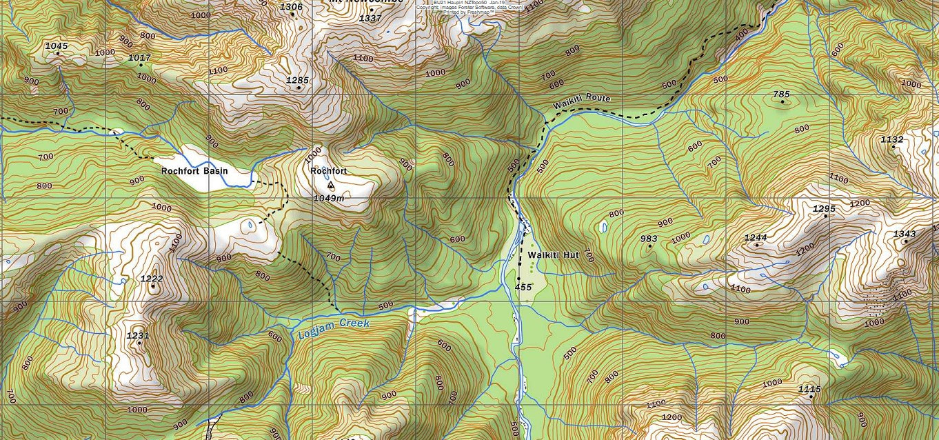
There is an alternative route into the Waikiti valley up Crane Creek to Rochfort Basin, then over a low saddle into Logjam Creek. The tracked bits on this route had deteriorated considerably from the early 2000's when Mauricio Lloreda of Permolat started taking an interest in it and trimmed and re-marked parts of it. In January 2021 Mauricio flew a crew into the basin to do some comprehensive work in the upper half of Crane Creek. The BCT provided funding for this. The lower valley section was finished off on foot from the Haupiri road end in February 21 and the last bits from the Rochfort tops down into the Waikiti in November 21 and this September.
The track starts in the shingle pit on the TR of Crane Creek 50m up from the bridge. It follows the Creek up initially crossing A number of times before swinging hard left and climbing steeply up onto sloping bush terrace on the TR. It climbs more gradually from here to around the 500m contour, then sidles through a series of gullies back into the creek. Then track climbs from the conspicuous ninety-degree corner and sidles high for a bit before dropping back into the riverbed. It continues upriver to an old fly camp site, then crosses to the TL and heads up through a trench to the South of the little hill at the edge the Rochfort Basin. The least swampy passage around the basin is on the North side past the old hut site. A trail with waratahs leads from the head of the basin to up the left of the saddle into Logjam Creek. Drop down to the Saddle and up onto the knoll with tarn to its SW. The Logjam track starts in patchy scrub 500m from the tarn in a SE direction at E1503582/ N5281463 (BU21 036 815). The track entrance in the Creek at the bottom end is at E1504233/ N5280892 (BU21 042 809). Mauricio also did some work along the bush fringes of the Creek, so you don't always have to wade up the middle.
The Waikiti River can usually be forded without problems near the confluence. Allow five hours from the roadend to Rochford and another three from there to Waikiti Hut using this route. Crane Creek Hut in Rochfort Basin, marked on the older topo maps, burned down some years back.
There are several possible crossings from the Waikiti over to the Trent valley. One is via an unnamed saddle ESE of Waikiti Hut. The creek that provides access from the Waikiti side is wrongly marked on the map. It actually turns North when it hits the valley floor and enters the river downstream from the Hut. The creek can be followed most of the way with the odd detour on the TL. Thick red beech logs, fern, and bush lawyer slow progress around the 700m contour, but further up some good deer trails 20 - 40m above the stream can be followed. Allow four hours from the Hut to the saddle. A suggested alternative involves heading upvalley one kilometre from the Hut, climbing through the bush to the 800m contour, and sidling at this height around to the saddle. The spur leading from the saddle down into the Trent is good open travel at the top and reportedly steep and horrible lower down. Once in the Trent it is easy river travel with judicious crossings down to the Tutaekuri River. Allow a full day to reach Tutaekuri Hut from Waikiti Hut.
For those heading to Mid Trent Hut another option is to head 3km upriver from Waikiti Hut towards an obvious steep scree coming off Pt 1390m. The creek draining the scree is incorrectly marked as feeding into the next side-creek downvalley. In reality it follows its own bed directly into the Waikiti, hitting the river at around 1505972E/ 5278283N. Head up the creek detouring into the adjoining bush where necessary until it transitions to scree. The scree is steep and active but provides good quick access to the tussock. Continue in an obvious line through a low saddle with a large tarn and along the ridge to Pt 1420m. Continue down the broad spur on the TL of Graf Creek. Travel is open and easy and lower down passes through a band of patchy scrub. From the 900m contour down to the river it is a bit of a grovel. The spur gets quite steep and rough underfoot, and it is necessary to zig-zag around bluffy patches. Once in the river it is easy travel to Mid Trent. Allow 6-8 hours for the crossing in summer conditions.
A saddle in the head of the Waikiti provides access over to Top Trent Hut. The upper Waikiti is negotiable but has numerous rough and bouldery bits. Some of the lower ones can be bypassed using deer trails however further up there is a fair amount of scrambling required. The descent on the Trent side is down the broad spur on the TL of the creek that drains the saddle. The creek itself has three waterfalls in it, and should be avoided. Fording the Trent River at the bottom of the descent is OK at normal flows, and it's about 15 minutes from here down the track on the TR to the Hut. A recent party took 10 hours to do the reverse trip from Top Trent to Waikiti Hut.
 Mt Newcombe tops
An alternative route out of the valley via the Mt Newcombe tops is doable, but a bit of a mixed bag. The tops are great, easy walking and can be accessed from the top of the Logjam Creek track in a couple of hours. They are adequately sprinkled with tarns and good campsites. The descent from the end of the range down to point 406m and the road isn't that flash. It is steep and rough underfoot, and there is an extended alpine scrub zone, (looks like it's been burnt off some time way back) followed by beech forest with a very thick understory. There is the very occasional open bit, then a nice band of supplejack just before you hit the valley floor. It would be a fairly big day in good conditions getting out this way from Waikiti Hut.
Another tops route worth considering is up Logjamb Creek and over Mt Mason to the Haupiri valley. A section of ridge 1.5km East of Mt Mason drops into the alpine scrub zone and is best sidled at the 980-metre contour on the South side. There is no easy way through around 120 lineal metres of some very dense stuff here. An old tops track which used to lead from Mt Mason down to the Haupiri River has seen better days. There is several hundred metres of quite tall dracopyllum to pass through in order to find the track's top entrance marked with a permolat "T." The spur is broad here and the start could be easily missed. Remain on the centre of the spur to the beginning of the taller scrub canopy at around 1000m. Simon, Mauricio and Peter Alspach did a bit of trimming and marking on this section in 2018 and the line is still quite easy to follow. From around 850m to 650m the route is obliterated by windfall and regrowth. Below 650m the ridge becomes better defined and the old trackline is followable, albeit steep and slippery, until about 500m. The 2018 team cruise-taped from 600m to the valley floor avoiding the old trackline at the bottom end due to windfall. Allow a full day for the traverse from the Waikiti and take a tent if you are coming up from the Haupiri side.
Repairs
Craig is planning to replace the hearth surround at some point. The roof needs to have the lead head nails and ridging replaced. The window frames need repainting and the three dozy piles replaced. The door needs fixing, and a new bolt attached.
Provisions on Site
There are two billies, two frypans, a pot, a 20-litre plastic bucket, two stainless steel buckets, an aluminium bucket, an aluminium wash basin, an axe, a shovel, a grubber, a mouse trap, two hearth brushes with dustpans, a big broom and an NZFS food drum (This is not a rubbish bin!).
