Burn Creek Hut
Maintenance Status
It is unlikely that Burn Creek Hut had much in the way of maintenance after it was built in 1958 however, the local high-country community thought it was worth fixing up. Graeme Coop of Nelson who has a longstanding connection with the place, obtained some Back Country Trust funding and did some scoping and organised a building team to do a major overhaul in February 2024. The route up the valley was first established by gold miners in the mid 1800s followed by the New Zealand Forest Service from the late 1950's onwards. At the bottom of the Creek a Department of Conservation sign states that the track has not been maintained since 1994. A note in the hut book from 1991 complains about the state of the track even then. The route from Jacobs ladder up is a mix of ancient white NZFS permolat, occasional blazes, and newer blue plastic markers. Restoration of the Hut which will most likely incorporate some trackwork. Graeme did some trimming on parts of the route in November 2023.
Location
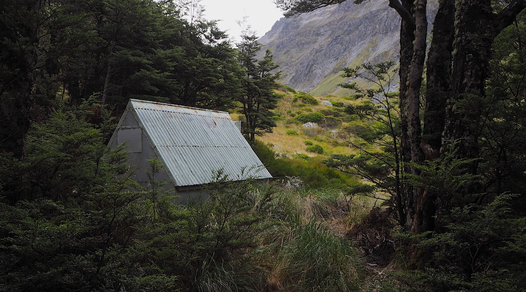
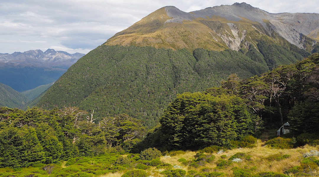
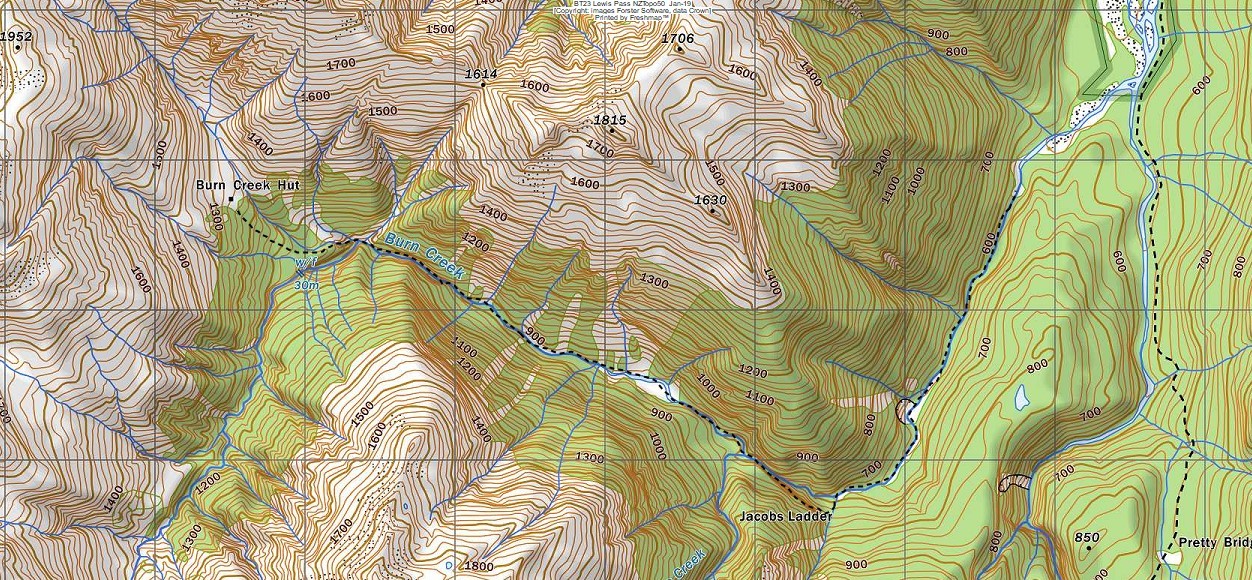
Matakitaki river catchment. NZTopo50 map sheet: BT23, Grid/NZTM2000 coordinates: E1554518, N5332738, altitude 1260m. Burn Creek Hut is in a beautiful spot nestled against the forest edge of a spectacular alpine basin on the Emily Peaks range in the SW corner of Nelson Lakes National Park. Visits have been few and far between over the decades and currently average 3-4 per year. There were no hut book entries in 2018 or during a four-year period from 2002 until 2006. There is a river flat upstream of Jacobs Ladder that was inhabited by gold miners in the 1870s, and again during the great depression. Some piles of stacked rocks are the only visible remnants.
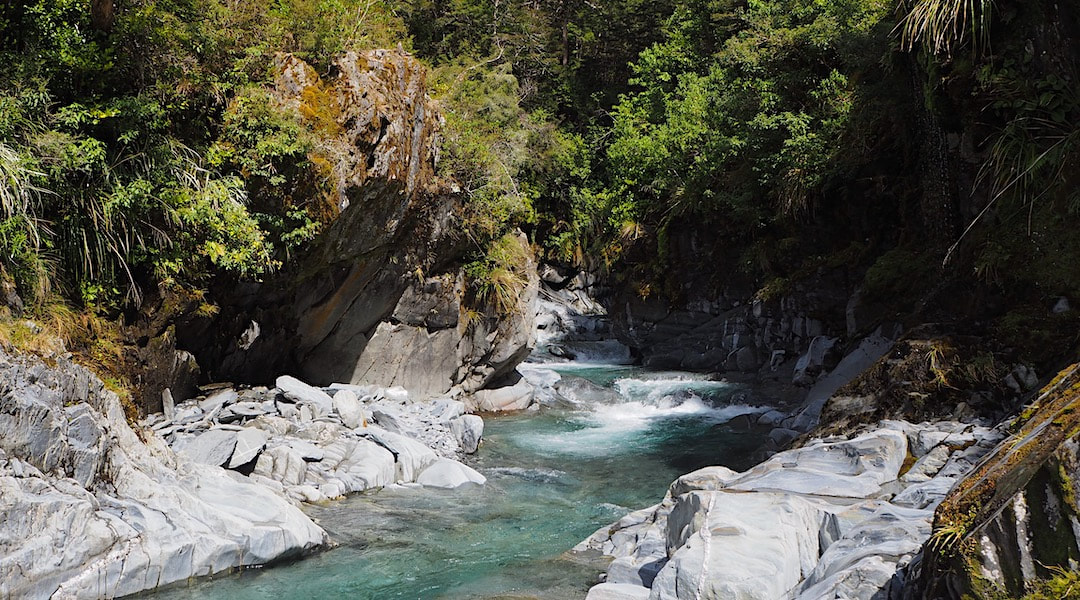 Burn Creek just before the waterfall: Photo Graeme Coop
Access
Many visitors to Burn Creek come from either Nardoo or Bobs Hut over the tops. This is only for the energetic and requires decent weather. Those wanting to come up Burn Creek will also need to be fit and experienced. From Downie Hut a crossing of the Matakitaki is required making it a fine weather route only. It is easier to cross the river close to the Hut than further up. The track up the lower portion of Burn Creek is pretty well washed out but it’s easy enough to follow the creek bed, crossing as required. The track around Jacobs Ladder starts at a steep blown out creek that enters the Burn on the TR at E1558539/ N5330759. A permolat cross and a cairn mark the exit point around 100m up the side-creek and a rough but well-marked route takes you up to a steep section with a length of Number 8 wire to assist the climb (probably not that trustworthy). The route from here is well-marked with blue plastic markers. It stays above the bluffs before dropping to the flat with the old gold workings. Continue up the creek bed from here. A small waterfall can be skirted on the TR to reach an open grassy area at the junction of some side-creeks. From here there is a climb adjacent to a waterfall to the top of a flat ridge, then a short bush-bash to get to the Hut. Graeme did some re-cutting work on bits of the tracked section in November 2023. Allow 7-10 hours from Downie Creek to Burn Creek Hut.
Helicopter access has historically been forbidden due to the Hut's location within the National Park. Lately however, high deer numbers on the tops have led to a temporary policy change and recreational hunters have been permitted to fly-in for control purposes.
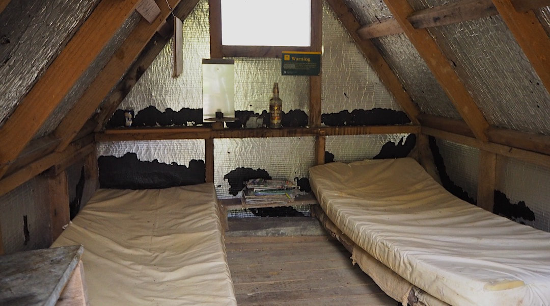 Burn Creek interior: Photo Graeme Coop
Type
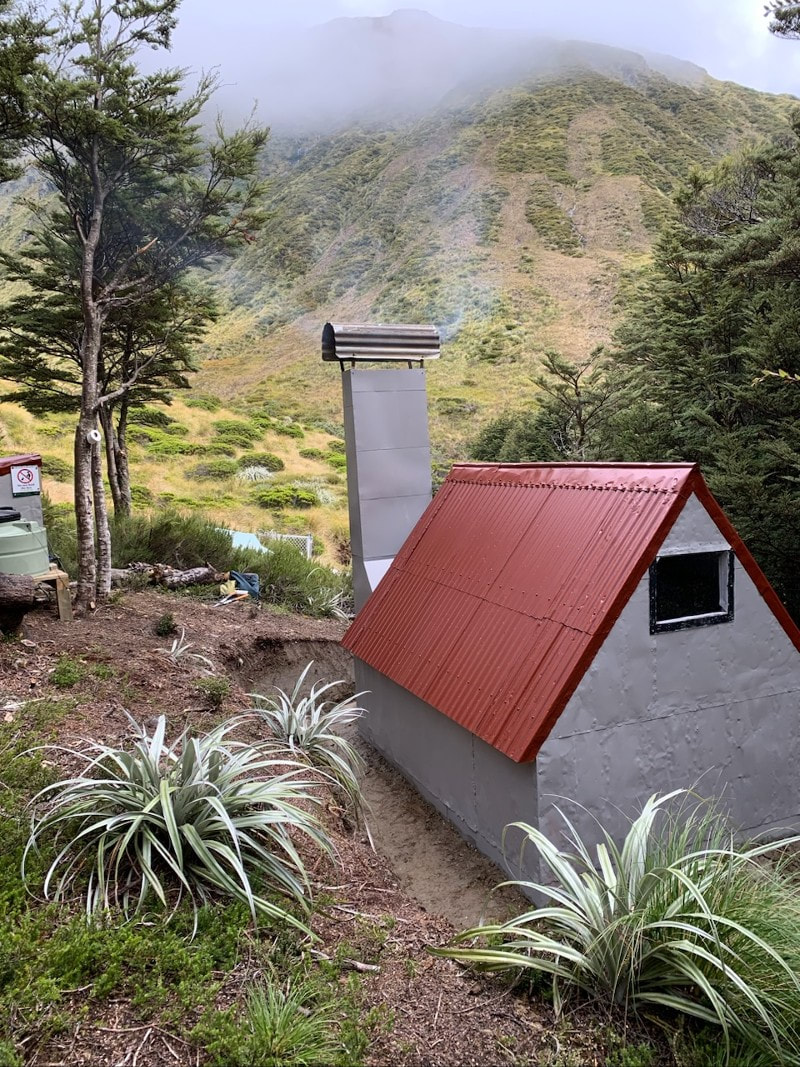
Burn Creek Hut could be more correctly classified as a bivouac. It is a one-off structure built in 1958 after Jock Fisher of the NZFS got Ray Osman to go in and erect "a bivi you could stand up in," Materials were leftovers from the construction of Bobs Hut further up the Matakitaki valley. The hut's frame sat on the ground (no piles), and it was lined with chicken wire and tar paper with rudimentary plastic windows at the end and in the door. It had a fireplace and chimney with an external wooden frame next to the door and two low-level platforms with mattresses resting on a planked section of floor extending to the end of the sleeping area. The remainder of the floor from here to the door was river rock. There was no toilet and poor water supply.
Graeme's 2024 team was led by Roger Gaskell, and included Martin Douglass, Mike Graham and Simon Field. They stripped the hut back to the frame which was shifted aside while a new, sturdier floor plate was constructed. The tar paper was replaced with building paper, the cladding rust treated, patched, and refastened with tech screws on the roof and galvanised flatheads on the sides. The sleeping platform was rebuilt, raised, and had a damp-proof membrane underlaid. The frame was braced, and piles placed under the floor plate on the east wall to counteract slumping. A concrete hearth was laid, and the chimney replaced with a strengthened, elongated version. A woodshed, toilet and water tank fed from the woodshed roof constructed.
Condition
Burn Creek has been assessed as being on the brink, but retrievable. Graeme Coop says it needs some love and attention but is, still comfortable and watertight. The timber framing is not drawing up too much moisture despite resting on the ground although the wooden bottom plates upon which everything rests are rotting. The door/ chimney end of the hut has no timber bracing, and the wall is spreading, and the door gap opening up. The hut was cut into the hillside and the east wall which was built on compacted earth is slumping. The chimney has no base and is in bad shape and rusting away at the top.
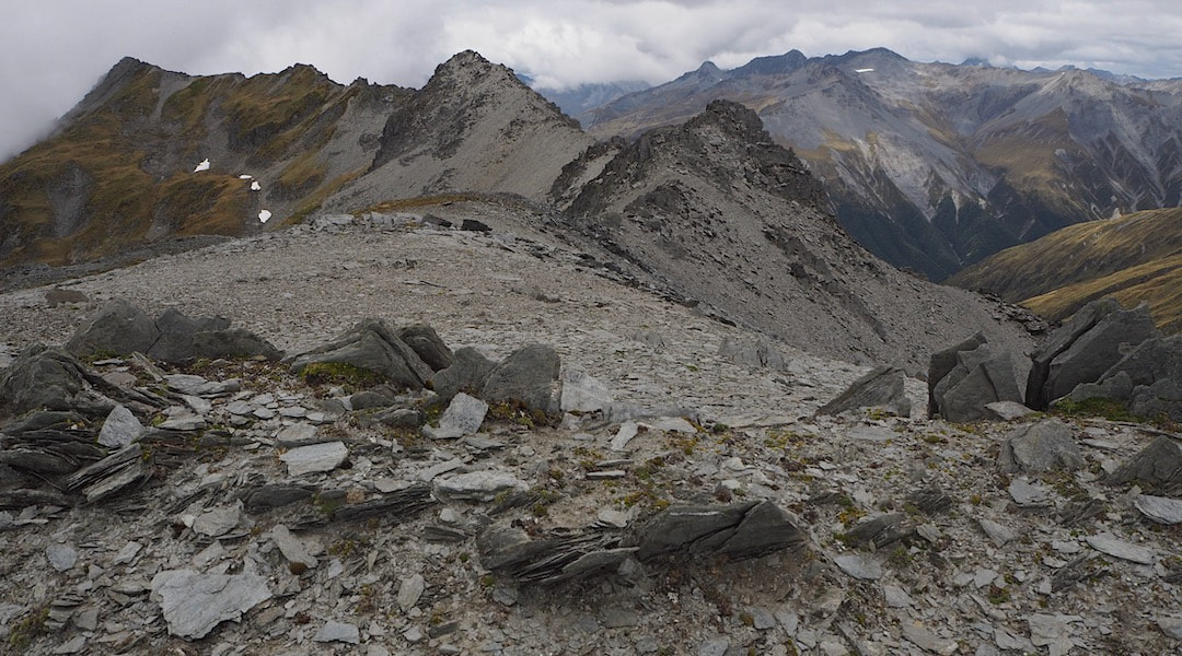 Emily Peaks from Point 2024m: Photo Graeme Coop
Routes
There is a high-level route linking Burn Creek with Nardoo Hut that can be undertaken by hardier types. The most direct line is straight up Burn Creek basin. There is a 15m waterfall that needs to be skirted if you do this. The alternative is to go up the ridge behind the Hut. From here the crest of the range is followed past Emily Peak, points 1916m, 1786m to the low point between an unnamed bump and point 1840m. Care needs to be taken on the descent as there are bluffs that can't be seen from above. Drop down the slope here towards a gut, hanging close to the right as you get towards the cliffs. There is a short section immediately above a decent bluff that needs to be traversed. There is flax growing here to hang onto and once over this pitch it is a straightforward amble down to Nardoo Hut which is visible as you descend. The head of Burn Creek is avalanche prone in the colder months. The rest of the traverse is an alpine crossing and necessitates the carrying of appropriate snow gear depending on the season and conditions. In late summer and autumn when snow-free it is a more straightforward affair, although still prone to the usual alpine weather extremes. Allow 6-10 hours for the crossing.
Access is also possible from the Southern end of the range and Bobs Hut. There is an old unmaintained track up the TR of the big creek that feeds into Mt Maling Creek. The creek is named as Sunshine Valley on all the old topographic maps, just not the current one for some strange reason. The track is no longer marked either. It was getting a bit vague by 2003, so it's likely to be vaguer now. The crossing from the head of the creek is an alpine one that requires the requisite skill levels.
Repairs needed.
None on the hut currently. It's likely that more trackwork will need to be done in conjunction with the hut repairs.
Provisions on site
There’s a shovel without a handle, a bow saw, an axe, two billies and an aluminium basin.
